Brackenridge, Pennsylvania
| Brackenridge | |
| Borough | |
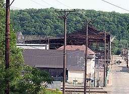 The Allegheny Ludlum Brackenridge Works along Mile Lock Lane at Vermont Avenue | |
| Official name: Borough of Brackenridge | |
| Named for: Henry Marie Brackenridge | |
| Country | United States |
|---|---|
| State | Pennsylvania |
| County | Allegheny |
| River | Allegheny River |
| Elevation | 827 ft (252 m) |
| Coordinates | 40°36′30″N 79°44′32″W / 40.60833°N 79.74222°WCoordinates: 40°36′30″N 79°44′32″W / 40.60833°N 79.74222°W |
| Area | 0.6 sq mi (1.6 km2) |
| - land | 0.5 sq mi (1.3 km2) |
| - water | 0.04 sq mi (0.1 km2) |
| Population | 3,260 (2010) |
| Density | 5,433.3/sq mi (2,097.8/km2) |
| Incorporated | September 21, 1901 [1] |
| Timezone | EST (UTC-5) |
| - summer (DST) | EDT (UTC-4) |
| ZIP code | 15014 |
| Area code | 724 |
| School district | Highlands |
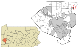 Location in Allegheny County and the state of Pennsylvania
| |
 Location of Pennsylvania in the United States
| |
| Website: http://brackenridgeborough.com/index.html | |
Brackenridge is a borough in Allegheny County in the U.S. state of Pennsylvania, along the Allegheny River. It is part of the Pittsburgh Metro Area.
The town is named for Henry Marie Brackenridge. The borough once had glass factories. An Allegheny Technologies steel mill, Allegheny Ludlum Brackenridge Works,[2] plays a prominent role in the community, although most of the facility is located in Harrison Township. The population stood at 3,421 in 1910 and at 6,400 in 1940. The population was 3,260 at the 2010 census.[3]
Geography
Brackenridge is located at 40°36′30″N 79°44′32″W / 40.60833°N 79.74222°W.[4] The borough's average elevation is 827 feet (252 m) above sea level.[5]
According to the United States Census Bureau, the borough has a total area of 0.6 square miles (1.6 km2), of which 0.5 square miles (1.3 km2) is land and 0.04 square miles (0.10 km2), or 7.27%, is water.
Demographics
| Historical population | |||
|---|---|---|---|
| Census | Pop. | %± | |
| 1910 | 3,134 | — | |
| 1920 | 4,987 | 59.1% | |
| 1930 | 6,256 | 25.4% | |
| 1940 | 6,400 | 2.3% | |
| 1950 | 6,178 | −3.5% | |
| 1960 | 5,697 | −7.8% | |
| 1970 | 4,796 | −15.8% | |
| 1980 | 4,297 | −10.4% | |
| 1990 | 3,784 | −11.9% | |
| 2000 | 3,543 | −6.4% | |
| 2010 | 3,260 | −8.0% | |
| Est. 2015 | 3,211 | [6] | −1.5% |
| Sources:[7][8][9][10][11][12][13] | |||
As of the census[12] of 2000, there were 3,543 people, 1,507 households, and 931 families residing in the borough. The population density was 6,924.2 people per square mile (2,682.3/km²). There were 1,700 housing units at an average density of 3,322.4 per square mile (1,287.0/km²). The racial makeup of the borough was 95.03% White, 3.44% African American, 0.11% Native American, 0.23% Asian, 0.03% Pacific Islander, 0.37% from other races, and 0.79% from two or more races. Hispanic or Latino of any race were 0.54% of the population.
There were 1,507 households, out of which 24.6% had children under the age of 18 living with them, 43.9% were married couples living together, 13.6% had a female householder with no husband present, and 38.2% were non-families. 34.2% of all households were made up of individuals, and 17.3% had someone living alone who was 65 years of age or older. The average household size was 2.28 and the average family size was 2.91.
In the borough the population was spread out, with 20.5% under the age of 18, 7.2% from 18 to 24, 28.1% from 25 to 44, 22.0% from 45 to 64, and 22.3% who were 65 years of age or older. The median age was 41 years. For every 100 females there were 80.7 males. For every 100 females age 18 and over, there were 78.3 males.
The median income for a household in the borough was $30,050, and the median income for a family was $41,803. Males had a median income of $30,661 versus $21,821 for females. The per capita income for the borough was $19,040. About 6.8% of families and 9.4% of the population were below the poverty line, including 15.9% of those under age 18 and 9.9% of those age 65 or over.
Education
Brackenridge is within the Highlands School District, which operates Fairmount Primary Center (grades K–2), formerly Fairmount Elementary School (grades K–5), on the hill section in the borough.[14]
Notable people
- Bud Carson – Defensive coordinator for the Pittsburgh Steelers and former head coach of the Cleveland Browns, born in Brackenridge.
- Cookie Gilchrist – African-American civil rights activist and former American Football League and Canadian Football League superstar, born in Brackenridge.
- Ronald Robertson – Figure skater and Olympic silver medalist.[15]
References
- ↑ "Allegheny County – 2nd Class" (PDF). Retrieved 2007-08-25.
- ↑ "Process and Plant Capabilities—Brackenridge, PA". Retrieved 2009-03-29.
- ↑ "Race, Hispanic or Latino, Age, and Housing Occupancy: 2010 Census Redistricting Data (Public Law 94-171) Summary File (QT-PL), Brackenridge borough, Pennsylvania". U.S. Census Bureau, American FactFinder 2. Archived from the original on September 11, 2013. Retrieved September 9, 2011.
- ↑ "US Gazetteer files: 2010, 2000, and 1990". United States Census Bureau. 2011-02-12. Retrieved 2011-04-23.
- ↑ "Borough of Brackenridge". Geographic Names Information System. United States Geological Survey. Retrieved 2009-12-02.
- ↑ "Annual Estimates of the Resident Population for Incorporated Places: April 1, 2010 to July 1, 2015". Retrieved July 2, 2016.
- ↑ "Population of Civil Divisions Less than Counties" (PDF). 1880 United States Census. U.S. Census Bureau. Retrieved 24 November 2013.
- ↑ "Population-Pennsylvania" (PDF). U.S. Census 1910. U.S. Census Bureau. Retrieved 22 November 2013.
- ↑ "Number and Distribution of Inhabitants:Pennsylvania-Tennessee" (PDF). Fifteenth Census. U.S. Census Bureau.
- ↑ "Number of Inhabitants: Pennsylvania" (PDF). 18th Census of the United States. U.S. Census Bureau. Retrieved 22 November 2013.
- ↑ "Pennsylvania: Population and Housing Unit Counts" (PDF). U.S. Census Bureau. Retrieved 22 November 2013.
- 1 2 "American FactFinder". United States Census Bureau. Archived from the original on 2013-09-11. Retrieved 2008-01-31.
- ↑ "Annual Estimates of the Resident Population". U.S. Census Bureau. Retrieved 22 November 2013.
- ↑ "Fairmount Elementary School". Geographic Names Information System. United States Geological Survey. Retrieved 2010-10-16.
- ↑ Goldstein, Richard (February 17, 2000). "Ronnie Robertson, 62, a Skater Who Entertained With His Spins". New York Times.
External links
| Counties |  Map of the Pittsburgh Tri-State with green counties in the metropolitan area and yellow counties in the combined area. | |
|---|---|---|
| Major cities | ||
| Cities and towns 15k-50k (in 2010) | ||
| Airports | ||
| Topics | ||
| ||