Millvale, Pennsylvania
| Millvale, Pennsylvania | |
| Borough | |
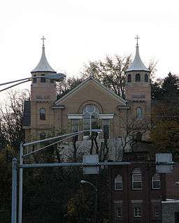 St. Nicholas Croatian Church in Millvale | |
| Country | United States |
|---|---|
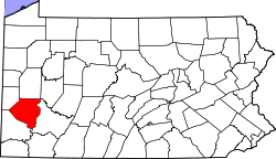
| State | Pennsylvania |
| County | Allegheny |
| Coordinates | 40°28′58.69″N 79°58′25.41″W / 40.4829694°N 79.9737250°WCoordinates: 40°28′58.69″N 79°58′25.41″W / 40.4829694°N 79.9737250°W |
| Population | 3,744 (2010) |
| Timezone | EST (UTC-5) |
| - summer (DST) | EDT (UTC-4) |
| ZIP code | 15209 |
| Area code | 412 |
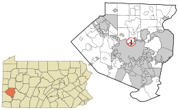 Location in Allegheny County and the state of Pennsylvania | |
| Website: www.millvalepa.com | |
Millvale is a borough in Allegheny County, Pennsylvania, along the Allegheny River, opposite Pittsburgh. In the past, it had iron manufactures, saw works, stone works, lumber mills, breweries, etc. The population was 3,744 at the 2010 census.[1]

History
The southern Half of Millvale was formerly part of Allegheny city limits Prior to its annexation by Pittsburgh in 1907. Until 1952 the borough was served by the "3 Millvale" trolley operated by Pittsburgh Railways.[2]
Geography
Millvale is located at 40°28′59″N 79°58′25″W / 40.48306°N 79.97361°W (40.482968, -79.973725).[3]
According to the United States Census Bureau, the borough has a total area of 0.7 square miles (1.8 km2), of which 0.6 square miles (1.6 km2) is land and 0.1 square miles (0.26 km2), or 9.72%, is water.
Millvale is located at the confluence of Girtys Run and the Allegheny River. Much of the borough is on a floodplain and has been subjected to extensive flooding at many times during its history.
Surrounding communities
Millvale is bordered by Pittsburgh to the southeast (across the Allegheny River), Reserve Township to the west and north, and Shaler Township to the northeast.
Demographics
| Historical population | |||
|---|---|---|---|
| Census | Pop. | %± | |
| 1870 | 668 | — | |
| 1880 | 1,824 | 173.1% | |
| 1890 | 3,809 | 108.8% | |
| 1900 | 6,736 | 76.8% | |
| 1910 | 7,861 | 16.7% | |
| 1920 | 8,031 | 2.2% | |
| 1930 | 8,166 | 1.7% | |
| 1940 | 7,811 | −4.3% | |
| 1950 | 7,287 | −6.7% | |
| 1960 | 6,624 | −9.1% | |
| 1970 | 5,815 | −12.2% | |
| 1980 | 4,772 | −17.9% | |
| 1990 | 4,341 | −9.0% | |
| 2000 | 4,028 | −7.2% | |
| 2010 | 3,744 | −7.1% | |
| Est. 2015 | 3,689 | [4] | −1.5% |
| Sources:[5][6][7][8][9][10][11] | |||
As of the census[10] of 2000, there were 4,028 people, 1,839 households, and 959 families residing in the borough. The population density was 6,187.1 people per square mile (2,392.6/km²). There were 2,085 housing units at an average density of 3,202.6 per square mile (1,238.5/km²). The racial makeup of the borough was 97.00% White, 0.97% African American, 0.20% Native American, 0.17% Asian, 0.67% from other races, and 0.99% from two or more races. Hispanic or Latino of any race were 0.89% of the population.
There were 1,839 households, out of which 26.8% had children under the age of 18 living with them, 32.6% were married couples living together, 14.4% had a female householder with no husband present, and 47.8% were non-families. 41.6% of all households were made up of individuals, and 14.4% had someone living alone who was 65 years of age or older. The average household size was 2.16 and the average family size was 2.96.
In the borough the population was spread out, with 23.5% under the age of 18, 9.9% from 18 to 24, 32.4% from 25 to 44, 19.7% from 45 to 64, and 14.5% who were 65 years of age or older. The median age was 36 years. For every 100 females there were 95.6 males. For every 100 females age 18 and over, there were 93.6 males.
The median income for a household in the borough was $26,509, and the median income for a family was $30,478. Males had a median income of $27,624 versus $22,278 for females. The per capita income for the borough was $14,526. About 11.2% of families and 13.2% of the population were below the poverty line, including 15.3% of those under age 18 and 5.7% of those age 65 or over.
Culture
St. Nicholas Roman Catholic Church, on Maryland Avenue in Millvale, was the first Croatian parish in America.[12] Painted on the walls of the church are the world-renowned murals of Croatian artist Maksimilijan Vanka. These murals, painted in the 1930s and 1940s, were Vanka's gift to the United States.
Recreation
Millvale Riverfront Park provides a 1.7 mile bike and walking trail that provides access from Millvale to Pittsburgh's North Shore, PNC Park, and Heinz Stadium along the Three Rivers Heritage Trail. The trail meanders along the Allegheny River, past Herr's Island, the TRRA Millvale Boathouse and into the Millvale Riverfront park. Plans for a bike/pedestrian bridge from the Millvale riverfront to Herr's island has received partial funding from DCNR and plans to connect the Millvale Trail to points north are being discussed. Access to the Millvale business district is less than half a mile away and restrooms are available. Other park amenities include a beautiful pavilion with riverfront access and a full kitchen, Mr.Smalls Skate Park, bike and boat rental, Millvale Marina, kayak and rowing boat launch access, fishing, tackle and bait shop, and more. The Riverfront Park is also home to the wildly popular annual BrewFest in August and the newly launched, well-crafted Harvest Moon Wine Festival in the Fall.
Most recently, the Millvale Community Library has been launched as an all-volunteer effort of community members to take several vacant buildings and lots and turn them into a multi-use space centered on creating Millvale's first public library and associated garden space. This project was launched by community volunteers and Pittsburgh-based non-profit organization, New Sun Rising, in 2007 and has enlisted hundreds of volunteers to help turn this community dream into a reality.
References
- ↑ "Race, Hispanic or Latino, Age, and Housing Occupancy: 2010 Census Redistricting Data (Public Law 94-171) Summary File (QT-PL), Millvale borough, Pennsylvania". U.S. Census Bureau, American FactFinder 2. Retrieved September 21, 2011.
- ↑ "Pittsburghtransit.com - The Routes - PCC Operation". August 28, 2005. Archived from the original on August 28, 2005. Retrieved August 9, 2009.
- ↑ "US Gazetteer files: 2010, 2000, and 1990". United States Census Bureau. 2011-02-12. Retrieved 2011-04-23.
- ↑ "Annual Estimates of the Resident Population for Incorporated Places: April 1, 2010 to July 1, 2015". Retrieved July 2, 2016.
- ↑ "Population of Civil Divisions Less than Counties" (PDF). 1880 United States Census. U.S. Census Bureau. Retrieved 24 November 2013.
- ↑ "Population-Pennsylvania" (PDF). U.S. Census 1910. U.S. Census Bureau. Retrieved 22 November 2013.
- ↑ "Number and Distribution of Inhabitants:Pennsylvania-Tennessee" (PDF). Fifteenth Census. U.S. Census Bureau.
- ↑ "Number of Inhabitants: Pennsylvania" (PDF). 18th Census of the United States. U.S. Census Bureau. Retrieved 22 November 2013.
- ↑ "Pennsylvania: Population and Housing Unit Counts" (PDF). U.S. Census Bureau. Retrieved 22 November 2013.
- 1 2 "American FactFinder". United States Census Bureau. Retrieved 2008-01-31.
- ↑ "Annual Estimates of the Resident Population". U.S. Census Bureau. Retrieved 22 November 2013.
- ↑ "US Board on Geographic Names". United States Geological Survey. 2007-10-25. Retrieved 2008-01-31.
External links
| Counties |  Map of the Pittsburgh Tri-State with green counties in the metropolitan area and yellow counties in the combined area. | |
|---|---|---|
| Major cities | ||
| Cities and towns 15k-50k (in 2010) | ||
| Airports | ||
| Topics | ||
| ||