Rosslyn Farms, Pennsylvania
| Rosslyn Farms | |
|---|---|
| Borough | |
|
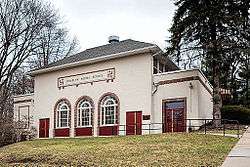
The former Rosslyn Farms School, now the Rosslyn Farms Community Center, located in the borough at the intersection of Kings Hwy and Priscilla Ln | |
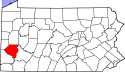
 Location in Allegheny County and the state of Pennsylvania | |
| Coordinates: 40°25′15″N 80°5′20″W / 40.42083°N 80.08889°WCoordinates: 40°25′15″N 80°5′20″W / 40.42083°N 80.08889°W | |
| Country | United States |
| State | Pennsylvania |
| County | Allegheny |
| Area | |
| • Total | 0.6 sq mi (2 km2) |
| • Land | 0.6 sq mi (2 km2) |
| Population (2010) | |
| • Total | 427 |
| • Density | 710/sq mi (270/km2) |
| Time zone | Eastern (EST) (UTC-5) |
| • Summer (DST) | EDT (UTC-4) |
| Website | Rosslyn Farms Borough |
Rosslyn Farms is a suburban borough located 5 miles (8 km) west of Pittsburgh in Allegheny County, Pennsylvania in the United States. It is a small community, with an area of only 0.6 square miles (1.6 km2). The population was 427 at the 2010 census.[1]
Surrounding communities
Rosslyn Farms is bordered by Carnegie to the south, Robinson Township to the west, Thornburg to the north, and Crafton and Pittsburgh to the east.
Geography
Rosslyn Farms is located at 40°25'15" North, 80°5'20" West (40.420969, -80.088768).[2]
According to the United States Census Bureau, the borough has a total area of 0.6 square miles (1.6 km2), all of it land.
Demographics
| Historical population | |||
|---|---|---|---|
| Census | Pop. | %± | |
| 1920 | 315 | — | |
| 1930 | 334 | 6.0% | |
| 1940 | 432 | 29.3% | |
| 1950 | 448 | 3.7% | |
| 1960 | 555 | 23.9% | |
| 1970 | 608 | 9.5% | |
| 1980 | 521 | −14.3% | |
| 1990 | 483 | −7.3% | |
| 2000 | 464 | −3.9% | |
| 2010 | 427 | −8.0% | |
| Est. 2015 | 427 | [3] | 0.0% |
| Sources:[4][5][6][7][8] | |||
As of the census[7] of 2000, there are 464 people, 185 households, and 145 families residing in the borough. The population density is 767.6 people per square mile (298.6/km²). There are 193 housing units at an average density of 319.3 per square mile (124.2/km²). The racial makeup of the borough is 99.14% White, 0.65% African American, 0.00% Native American, 0.00% Asian, 0.00% Pacific Islander, 0.00% from other races, and 0.22% from two or more races. 0.43% of the population are Hispanic or Latino of any race.
There are 185 households, out of which 30.3% have children under the age of 18 living with them, 71.4% are married couples living together, 3.8% have a female householder with no husband present, and 21.6% are non-families. 16.8% of all households are made up of individuals, and 5.9% have someone living alone who is 65 years of age or older. The average household size is 2.51 and the average family size is 2.84.
In the borough the population is spread out, with 23.9% under the age of 18, 3.0% from 18 to 24, 26.9% from 25 to 44, 31.9% from 45 to 64, and 14.2% who are 65 years of age or older. The median age is 44 years. For every 100 females there are 99.1 males. For every 100 females age 18 and over, there are 91.8 males.
The median income for a household in the borough is $100,125, and the median income for a family is $145,799. Males have a median income of $105,327 versus $73,083 for females. The per capita income for the borough is $71,612. 5.8% of the population and 2.6% of families are below the poverty line. Out of the total population, 16.3% of those under the age of 18 and 0.0% of those 65 and older are living below the poverty line.
History
Founded in 1902 by the Chartiers Land Company, Rosslyn Farms was developed by William Parrish.
The borough derives its name from Roslin, Scotland.[9]
References
- ↑ "Race, Hispanic or Latino, Age, and Housing Occupancy: 2010 Census Redistricting Data (Public Law 94-171) Summary File (QT-PL), Rosslyn Farms borough, Pennsylvania". U.S. Census Bureau, American FactFinder 2. Retrieved September 23, 2011.
- ↑ "US Gazetteer files: 2010, 2000, and 1990". United States Census Bureau. 2011-02-12. Retrieved 2011-04-23.
- ↑ "Annual Estimates of the Resident Population for Incorporated Places: April 1, 2010 to July 1, 2015". Retrieved July 2, 2016.
- ↑ "Number and Distribution of Inhabitants:Pennsylvania-Tennessee" (PDF). Fifteenth Census. U.S. Census Bureau.
- ↑ "Number of Inhabitants: Pennsylvania" (PDF). 18th Census of the United States. U.S. Census Bureau. Retrieved 22 November 2013.
- ↑ "Pennsylvania: Population and Housing Unit Counts" (PDF). U.S. Census Bureau. Retrieved 22 November 2013.
- 1 2 "American FactFinder". United States Census Bureau. Retrieved 2008-01-31.
- ↑ "Annual Estimates of the Resident Population". U.S. Census Bureau. Retrieved 22 November 2013.
- ↑ Ackerman, Jan (May 10, 1984). "Town names carry bit of history". Pittsburgh Post-Gazette. p. 6. Retrieved 31 October 2015.

