Twin Lakes, California
| Twin Lakes | |
|---|---|
| census-designated place | |
 Location in Santa Cruz County and the state of California | |
 Twin Lakes Location in the United States | |
| Coordinates: 36°57′48″N 121°59′37″W / 36.96333°N 121.99361°WCoordinates: 36°57′48″N 121°59′37″W / 36.96333°N 121.99361°W | |
| Country |
|
| State |
|
| County | Santa Cruz |
| Area[1] | |
| • Total | 1.210 sq mi (3.136 km2) |
| • Land | 0.690 sq mi (1.788 km2) |
| • Water | 0.520 sq mi (1.348 km2) 42.98% |
| Elevation | 52 ft (16 m) |
| Population (2010) | |
| • Total | 4,917 |
| • Density | 4,100/sq mi (1,600/km2) |
| Time zone | PST (UTC-8) |
| • Summer (DST) | PDT (UTC-7) |
| ZIP code | 95066/95067 |
| Area code(s) | 831 |
| FIPS code | 06-81050 |
| GNIS feature ID | 1660053 |
Twin Lakes is a census-designated place (CDP) in Santa Cruz County, California, United States. The population was 4,917 at the 2010 census.
Geography
Twin Lakes is located at 36°57′48″N 121°59′37″W / 36.96333°N 121.99361°W (36.963450, -121.993498).[2]
According to the United States Census Bureau, the CDP has a total area of 1.2 square miles (3.1 km2), of which, 0.7 square miles (1.8 km2) of it is land and 0.5 square miles (1.3 km2) of it (42.98%) is water.
Demographics
2010
The 2010 United States Census[3] reported that Twin Lakes had a population of 4,917. The population density was 4,060.7 people per square mile (1,567.8/km²). The racial makeup of Twin Lakes was 3,900 (79.3%) White, 70 (1.4%) African American, 61 (1.2%) Native American, 126 (2.6%) Asian, 8 (0.2%) Pacific Islander, 534 (10.9%) from other races, and 218 (4.4%) from two or more races. Hispanic or Latino of any race were 1,109 persons (22.6%).
The Census reported that 4,782 people (97.3% of the population) lived in households, 35 (0.7%) lived in non-institutionalized group quarters, and 100 (2.0%) were institutionalized.
There were 2,223 households, out of which 463 (20.8%) had children under the age of 18 living in them, 669 (30.1%) were opposite-sex married couples living together, 232 (10.4%) had a female householder with no husband present, 102 (4.6%) had a male householder with no wife present. There were 227 (10.2%) unmarried opposite-sex partnerships, and 21 (0.9%) same-sex married couples or partnerships. 813 households (36.6%) were made up of individuals and 274 (12.3%) had someone living alone who was 65 years of age or older. The average household size was 2.15. There were 1,003 families (45.1% of all households); the average family size was 2.84.
The population was spread out with 770 people (15.7%) under the age of 18, 651 people (13.2%) aged 18 to 24, 1,572 people (32.0%) aged 25 to 44, 1,220 people (24.8%) aged 45 to 64, and 704 people (14.3%) who were 65 years of age or older. The median age was 36.8 years. For every 100 females there were 94.8 males. For every 100 females age 18 and over, there were 91.4 males.
There were 2,741 housing units at an average density of 2,263.7 per square mile (874.0/km²), of which 820 (36.9%) were owner-occupied, and 1,403 (63.1%) were occupied by renters. The homeowner vacancy rate was 3.5%; the rental vacancy rate was 3.9%. 1,673 people (34.0% of the population) lived in owner-occupied housing units and 3,109 people (63.2%) lived in rental housing units.
2000
As of the census[4] of 2000, there were 5,533 people, 2,409 households, and 1,038 families residing in the CDP. The population density was 7,928.9 people per square mile (3,051.9/km²). There were 2,745 housing units at an average density of 3,933.6 per square mile (1,514.1/km²). The racial makeup of the CDP was 78.84% White, 0.90% African American, 0.63% Native American, 2.30% Asian, 0.18% Pacific Islander, 12.43% from other races, and 4.72% from two or more races. Hispanic or Latino of any race were 22.54% of the population.
There were 2,409 households out of which 21.3% had children under the age of 18 living with them, 30.1% were married couples living together, 8.4% had a female householder with no husband present, and 56.9% were non-families. 37.2% of all households were made up of individuals and 12.7% had someone living alone who was 65 years of age or older. The average household size was 2.24 and the average family size was 2.99.
In the CDP the population was spread out with 17.0% under the age of 18, 15.5% from 18 to 24, 35.7% from 25 to 44, 17.9% from 45 to 64, and 13.8% who were 65 years of age or older. The median age was 33 years. For every 100 females there were 99.0 males. For every 100 females age 18 and over, there were 96.9 males.
The median income for a household in the CDP was $39,057, and the median income for a family was $47,198. Males had a median income of $35,417 versus $31,538 for females. The per capita income for the CDP was $25,342. About 7.5% of families and 14.9% of the population were below the poverty line, including 16.0% of those under age 18 and 3.5% of those age 65 or over.
Government
In the California State Legislature, Twin Lakes is in the 17th Senate District, represented by Democrat Bill Monning, and in the 29th Assembly District, represented by Democrat Mark Stone.[5]
In the United States House of Representatives, Twin Lakes is in California's 20th congressional district, represented by Democrat Sam Farr.[6]
References
- ↑ "2010 Census U.S. Gazetteer Files – Places – California". United States Census Bureau.
- ↑ "US Gazetteer files: 2010, 2000, and 1990". United States Census Bureau. 2011-02-12. Retrieved 2011-04-23.
- ↑ "2010 Census Interactive Population Search: CA - Twin Lakes CDP". U.S. Census Bureau. Retrieved July 12, 2014.
- ↑ "American FactFinder". United States Census Bureau. Retrieved 2008-01-31.
- ↑ "Statewide Database". UC Regents. Retrieved January 7, 2015.
- ↑ "California's 20th Congressional District - Representatives & District Map". Civic Impulse, LLC.
Municipalities and communities of Santa Cruz County, California, United States | ||
|---|---|---|
| Cities | 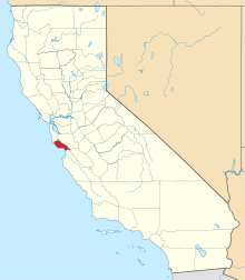 | |
| CDPs | ||
| Unincorporated communities | ||
| Ghost town | ||
| Counties |  | |
|---|---|---|
| Cities and towns 100k-250k | ||
| Cities and towns 25k-100k | ||
| Cities and towns 10k-25k | ||
| Sub-regions | ||
Counties in italics sometimes included in the definition of the Central Coast | ||
| Bodies of water |
|  |
|---|---|---|
| Counties | ||
| Major cities | ||
| Cities and towns 100k–250k | ||
| Cities and towns 50k–99k | ||
| Cities and towns 25k-50k | ||
| Cities and towns 10k–25k |
| |
| Sub-regions | ||