Interlaken, California
| Interlaken | |
|---|---|
| Census-designated place | |
 Location in Santa Cruz County and the state of California | |
 Interlaken Location in the United States | |
| Coordinates: 36°57′23″N 121°44′44″W / 36.95639°N 121.74556°WCoordinates: 36°57′23″N 121°44′44″W / 36.95639°N 121.74556°W | |
| Country |
|
| State |
|
| County | Santa Cruz |
| Named for | Interlaken |
| Area[1] | |
| • Total | 10.202 sq mi (26.423 km2) |
| • Land | 9.805 sq mi (25.396 km2) |
| • Water | 0.397 sq mi (1.027 km2) 3.89% |
| Elevation[2] | 128 ft (39 m) |
| Population (April 1, 2010) | |
| • Total | 7,321 |
| • Density | 720/sq mi (280/km2) |
| Time zone | Pacific Time Zone (UTC-8) |
| • Summer (DST) | PDT (UTC-7) |
| ZIP code | 95076 |
| Area code | 831 |
| FIPS code | 06-36613 |
| GNIS feature ID | 1867031 |
Interlaken is a census-designated place (CDP) in Santa Cruz County, California, United States. The population was 7,321 at the 2010 census.
Name
Named for the town of Interlaken in Switzerland meaning 'among the lakes'[3]
Geography
Interlaken is located at 36°57′23″N 121°44′44″W / 36.95639°N 121.74556°W (36.956293, -121.745433).[4]
According to the United States Census Bureau, the CDP has a total area of 10.2 square miles (26 km2), of which, 9.8 square miles (25 km2) of it is land and 0.4 square miles (1.0 km2) of it (3.89%) is water.
Demographics
2010
The 2010 United States Census[5] reported that Interlaken had a population of 7,321. The population density was 717.6 people per square mile (277.1/km²). The racial makeup of Interlaken was 3,856 (52.7%) White, 58 (0.8%) African American, 128 (1.7%) Native American, 302 (4.1%) Asian, 2 (0.0%) Pacific Islander, 2,573 (35.1%) from other races, and 402 (5.5%) from two or more races. Hispanic or Latino of any race were 5,261 persons (71.9%).
The Census reported that 98.5% of the population lived in households and 1.5% lived in non-institutionalized group quarters.
There were 1,690 households, out of which 885 (52.4%) had children under the age of 18 living in them, 1,075 (63.6%) were opposite-sex married couples living together, 227 (13.4%) had a female householder with no husband present, 123 (7.3%) had a male householder with no wife present. There were 92 (5.4%) unmarried opposite-sex partnerships, and 11 (0.7%) same-sex married couples or partnerships. 179 households (10.6%) were made up of individuals and 88 (5.2%) had someone living alone who was 65 years of age or older. The average household size was 4.27. There were 1,425 families (84.3% of all households); the average family size was 4.43.
The population was spread out with 2,138 people (29.2%) under the age of 18, 853 people (11.7%) aged 18 to 24, 2,039 people (27.9%) aged 25 to 44, 1,658 people (22.6%) aged 45 to 64, and 633 people (8.6%) who were 65 years of age or older. The median age was 30.5 years. For every 100 females there were 109.6 males. For every 100 females age 18 and over, there were 106.7 males.
There were 1,759 housing units at an average density of 172.4 per square mile (66.6/km²), of which 71.4% were owner-occupied and 28.6% were occupied by renters. The homeowner vacancy rate was 0.7%; the rental vacancy rate was 1.8%. 68.6% of the population lived in owner-occupied housing units and 29.8% lived in rental housing units.
2000
As of the census[6] of 2000, there were 7,328 people, 1,684 households, and 1,433 families residing in the CDP. The population density was 758.0 people per square mile (292.6/km²). There were 1,736 housing units at an average density of 179.6 per square mile (69.3/km²). The racial makeup of the CDP was 51.88% White, 1.01% African American, 1.28% Native American, 5.59% Asian, 0.07% Pacific Islander, 34.98% from other races, and 5.19% from two or more races. Hispanic or Latino of any race were 62.10% of the population.
There were 1,684 households out of which 48.9% had children under the age of 18 living with them, 67.8% were married couples living together, 12.1% had a female householder with no husband present, and 14.9% were non-families. 10.3% of all households were made up of individuals and 4.9% had someone living alone who was 65 years of age or older. The average household size was 4.30 and the average family size was 4.44.
In the CDP the population was spread out with 32.3% under the age of 18, 11.7% from 18 to 24, 30.3% from 25 to 44, 18.0% from 45 to 64, and 7.6% who were 65 years of age or older. The median age was 29 years. For every 100 females there were 107.0 males. For every 100 females age 18 and over, there were 106.6 males.
The median income for a household in the CDP was $53,875, and the median income for a family was $50,756. Males had a median income of $25,644 versus $26,750 for females. The per capita income for the CDP was $13,791. About 6.6% of families and 8.0% of the population were below the poverty line, including 5.6% of those under age 18 and 5.8% of those age 65 or over.
Government
In the California State Legislature, Interlaken is in the 17th Senate District, represented by Democrat Bill Monning, and in the 30th Assembly District, represented by Democrat Anna Caballero.[7]
In the United States House of Representatives, Interlaken is in California's 20th congressional district, represented by Democrat Sam Farr.[8]
References
- ↑ "2010 Census U.S. Gazetteer Files – Places – California". United States Census Bureau.
- ↑ "Interlaken". Geographic Names Information System. United States Geological Survey. Retrieved February 9, 2015.
- ↑ Gudde, Erwin G. (1998). California place names : the origin and etymology of current geographical names (4th ed., rev. and enl. ed.). Berkeley: University of California Press. p. 178. ISBN 0-520-21316-5.
- ↑ "US Gazetteer files: 2010, 2000, and 1990". United States Census Bureau. 2011-02-12. Retrieved 2011-04-23.
- ↑ "2010 Census Interactive Population Search: CA - Interlaken CDP". U.S. Census Bureau. Retrieved July 12, 2014.
- ↑ "American FactFinder". United States Census Bureau. Retrieved 2008-01-31.
- ↑ "Statewide Database". UC Regents. Retrieved December 30, 2014.
- ↑ "California's 20th Congressional District - Representatives & District Map". Civic Impulse, LLC.
External links
Municipalities and communities of Santa Cruz County, California, United States | ||
|---|---|---|
| Cities | 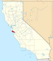 | |
| CDPs | ||
| Unincorporated communities | ||
| Ghost town | ||
| Counties |  | |
|---|---|---|
| Cities and towns 100k-250k | ||
| Cities and towns 25k-100k | ||
| Cities and towns 10k-25k | ||
| Sub-regions | ||
Counties in italics sometimes included in the definition of the Central Coast | ||