Opal Cliffs, California
| Opal Cliffs | |
|---|---|
|
unincorporated community (former census-designated place) | |
 Location in Santa Cruz County and the state of California | |
| Coordinates: 36°57′41″N 121°58′15″W / 36.96139°N 121.97083°WCoordinates: 36°57′41″N 121°58′15″W / 36.96139°N 121.97083°W | |
| Country |
|
| State |
|
| County | Santa Cruz |
| Area | |
| • Total | 5.2 km2 (2 sq mi) |
| • Land | 2 km2 (0.8 sq mi) |
| • Water | 3.2 km2 (1.2 sq mi) |
| Elevation | 14 m (46 ft) |
| Population (2000) | |
| • Total | 6,458 |
| • Density | 1,241.9/km2 (3,229/sq mi) |
| Time zone | PST (UTC-8) |
| • Summer (DST) | PDT (UTC-7) |
| ZIP code | 95062 |
| Area code(s) | 831 |
| FIPS code | 06-53924 |
| GNIS feature ID | 1659307 |
Opal Cliffs is an unincorporated community in Santa Cruz County, California, United States.
For statistical purposes, the United States Census Bureau defined Opal Cliffs as a census-designated place (CDP). The population was 6,458 at the 2000 census. The Opal Cliffs CDP was abolished prior to the 2010 census. The census definition of the area may not precisely correspond to local understanding of the area with the same name.
Geography
Opal Cliffs is located at 36°57′41″N 121°58′15″W / 36.96139°N 121.97083°W (36.961500, -121.970920).[1]
According to the United States Census Bureau, the CDP had a total area of 2.0 square miles (5.2 km2), of which, 0.8 square miles (2.1 km2) of it was land and 1.2 square miles (3.1 km2) of it (61.50%) was water.
Demographics
As of the census[2] of 2000, there were 6,458 people, 2,843 households, and 1,410 families residing in the CDP. The population density was 8,353.9 people per square mile (3,238.2/km²). There were 3,169 housing units at an average density of 4,099.3 per square mile (1,589.0/km²). The racial makeup of the CDP was 84.87% White, 0.98% African American, 0.77% Native American, 2.20% Asian, 0.14% Pacific Islander, 6.41% from other races, and 4.63% from two or more races. Hispanic or Latino of any race were 12.51% of the population.
There were 2,843 households out of which 24.6% had children under the age of 18 living with them, 33.5% were married couples living together, 10.7% had a female householder with no husband present, and 50.4% were non-families. 33.6% of all households were made up of individuals and 9.4% had someone living alone who was 65 years of age or older. The average household size was 2.24 and the average family size was 2.84.
In the CDP the population was spread out with 18.5% under the age of 18, 9.8% from 18 to 24, 36.7% from 25 to 44, 24.9% from 45 to 64, and 10.1% who were 65 years of age or older. The median age was 37 years. For every 100 females there were 104.8 males. For every 100 females age 18 and over, there were 102.6 males.
The median income for a household in the CDP was $42,673, and the median income for a family was $48,258. Males had a median income of $43,705 versus $31,729 for females. The per capita income for the CDP was $29,617. About 8.9% of families and 14.2% of the population were below the poverty line, including 13.6% of those under age 18 and 11.9% of those age 65 or over.
Government
In the California State Legislature, Opal Cliffs is in the 17th Senate District, represented by Democrat Bill Monning, and in the 29th Assembly District, represented by Democrat Mark Stone.[3]
In the United States House of Representatives, Opal Cliffs is in California's 20th congressional district, represented by Democrat Sam Farr.[4]
References
- ↑ "US Gazetteer files: 2010, 2000, and 1990". United States Census Bureau. 2011-02-12. Retrieved 2011-04-23.
- ↑ "American FactFinder". United States Census Bureau. Retrieved 2008-01-31.
- ↑ "Statewide Database". UC Regents. Retrieved January 7, 2015.
- ↑ "California's 20th Congressional District - Representatives & District Map". Civic Impulse, LLC.
External links
Municipalities and communities of Santa Cruz County, California, United States | ||
|---|---|---|
| Cities | 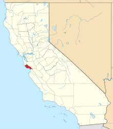 | |
| CDPs | ||
| Unincorporated communities | ||
| Ghost town | ||
| Counties |  | |
|---|---|---|
| Cities and towns 100k-250k | ||
| Cities and towns 25k-100k | ||
| Cities and towns 10k-25k | ||
| Sub-regions | ||
Counties in italics sometimes included in the definition of the Central Coast | ||