Port Hueneme, California
| City of Port Hueneme Hueneme (original settlement) | |
|---|---|
| Charter city | |
|
| |
 Location in Ventura county | |
 City of Port Hueneme Location in the United States | |
| Coordinates: 34°9′37″N 119°11′40″W / 34.16028°N 119.19444°WCoordinates: 34°9′37″N 119°11′40″W / 34.16028°N 119.19444°W | |
| Country |
|
| State |
|
| County | Ventura |
| Wharf constructed | 1871[1] |
| Street grid established | October 1, 1888[2] |
| Incorporated | March 24, 1948[3] |
| Government | |
| • Type | Council-mayor |
| • Mayor | Sylvia Muñoz Schnopp[4] |
| • State senator | Hannah-Beth Jackson (D)[5] |
| • Assemblymember | Jacqui Irwin (D)[5] |
| • U. S. rep. | Julia Brownley (D)[6] |
| Area[7] | |
| • Total | 4.671 sq mi (12.096 km2) |
| • Land | 4.451 sq mi (11.528 km2) |
| • Water | 0.220 sq mi (0.569 km2) 4.70% |
| Elevation[8] | 13 ft (4 m) |
| Population (April 1, 2010) | |
| • Total | 21,723 |
| • Density | 4,700/sq mi (1,800/km2) |
| Time zone | Pacific (UTC-8) |
| • Summer (DST) | PDT (UTC-7) |
| ZIP codes | 93041–93044 |
| Area code | 805 |
| FIPS code | 06-58296 |
| GNIS feature ID | 1652778 |
| Website |
www |

Port Hueneme (/ˌpɔːrt waɪˈniːmiː/ wy-NEE-mee) is a small beach city in Ventura County, California surrounded by the city of Oxnard and the Santa Barbara Channel.[9] The name derives from the Spanish spelling of the Chumash wene me, meaning "Resting Place". Juan Rodríguez Cabrillo explored this area and the adjacent Channel Islands in October 1542. The town's name was officially changed to Port Hueneme in 1939 and was incorporated March 24, 1948.
Thomas Bard learned of the submarine canyon at Point Hueneme[10] and took advantage of the canyon depth to construct the Hueneme Wharf in 1871 here.[1] The existing street grid of the town was formally laid out in 1888.[2] Until the construction of the Montalvo Cutoff that brought the railroad to nearby Oxnard, the wharf was the principal means of transportation for that portion of Ventura County lying south of the Santa Clara River. Hueneme was the second largest grain shipping port on the Pacific coast between 1871 and 1895.[1] Both the Port of Hueneme and Naval Base Ventura County lie within city limits.
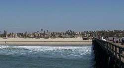
Port Hueneme has a south-facing sand beach, known for its surfing. The beach has a wooden fishing pier and is about a mile long between Ormond Beach[11] downcoast and Point Hueneme Light at the harbor entrance shared by the naval base and the port. The Waterfront Promenade, also known as the Lighthouse Promenade, provides a paved public access along the shoreline with two historic sites at view points: the 1872 Wharf and the Oxnard Packing House.[12][13] There are also picnic tables and barbecue grills.
Demographics
| Historical population | |||
|---|---|---|---|
| Census | Pop. | %± | |
| 1880 | 166 | — | |
| 1950 | 3,024 | — | |
| 1960 | 11,067 | 266.0% | |
| 1970 | 14,295 | 29.2% | |
| 1980 | 17,803 | 24.5% | |
| 1990 | 20,319 | 14.1% | |
| 2000 | 21,845 | 7.5% | |
| 2010 | 21,723 | −0.6% | |
| Est. 2015 | 22,423 | [14] | 3.2% |
2010
The 2010 United States Census[16] reported that Port Hueneme had a population of 21,723. The population density was 4,651.2 people per square mile (1,795.8/km²). The racial makeup of Port Hueneme was 12,357 (56.9%) White, 1,111 (5.1%) African American, 295 (1.4%) Native American, 1,299 (6.0%) Asian, 119 (0.5%) Pacific Islander, 5,224 (24.0%) from other races, and 1,318 (6.1%) from two or more races. Hispanic or Latino of any race were 11,360 persons (52.3%).
The Census reported that 20,854 people (96.0% of the population) lived in households, 869 (4.0%) lived in non-institutionalized group quarters, and 0 (0%) were institutionalized.
There were 7,080 households, out of which 2,832 (40.0%) had children under the age of 18 living in them, 3,267 (46.1%) were opposite-sex married couples living together, 1,121 (15.8%) had a female householder with no husband present, 440 (6.2%) had a male householder with no wife present. There were 458 (6.5%) unmarried opposite-sex partnerships, and 53 (0.7%) same-sex married couples or partnerships. 1,760 households (24.9%) were made up of individuals and 775 (10.9%) had someone living alone who was 65 years of age or older. The average household size was 2.95. There were 4,828 families (68.2% of all households); the average family size was 3.52.
The population was spread out with 5,781 people (26.6%) under the age of 18, 2,705 people (12.5%) aged 18 to 24, 6,258 people (28.8%) aged 25 to 44, 4,593 people (21.1%) aged 45 to 64, and 2,386 people (11.0%) who were 65 years of age or older. The median age was 31.3 years. For every 100 females there were 103.2 males. For every 100 females age 18 and over, there were 101.1 males.
There were 8,131 housing units at an average density of 1,741.0 per square mile (672.2/km²), of which 3,422 (48.3%) were owner-occupied, and 3,658 (51.7%) were occupied by renters. The homeowner vacancy rate was 2.7%; the rental vacancy rate was 6.0%. 9,747 people (44.9% of the population) lived in owner-occupied housing units and 11,107 people (51.1%) lived in rental housing units.
2000
As of the census[17] of 2000, there were 21,845 people, 7,268 households, and 5,000 families residing in the city. The population density was 4,912.9 inhabitants per square mile (1,895.4/km²). There were 7,908 housing units at an average density of 1,778.5 per square mile (686.1/km²). The racial makeup of the city was 57.27% White, 6.06% African American, 1.69% Native American, 6.33% Asian, 0.50% Pacific Islander, 21.84% from other races, and 6.30% from two or more races. Hispanic or Latino of any race were 41.02% of the population.
There were 7,268 households out of which 37.4% had children under the age of 18 living with them, 49.9% were married couples living together, 13.5% had a female householder with no husband present, and 31.2% were non-families. Twenty-four point one percent of all households were made up of individuals and 10.3% had someone living alone who was 65 years of age or older. The average household size was 2.86 and the average family size was 3.42.
In the city the population was spread out with 27.6% under the age of 18, 13.2% from 18 to 24, 32.0% from 25 to 44, 16.5% from 45 to 64, and 10.7% who were 65 years of age or older. The median age was 30 years. For every 100 females there were 101.2 males. For every 100 females age 18 and over, there were 100.7 males.
The median income for a household in the city was $42,246, and the median income for a family was $46,056. Males had a median income of $30,314 versus $25,703 for females. The per capita income for the city was $17,311. About 9.8% of families and 12.2% of the population were below the poverty line, including 16.7% of those under age 18 and 8.9% of those age 65 or over.
The Port
The Port of Hueneme, shared with Oxnard Harbor District and Naval Base Ventura County, is the only deep water port between the Port of Los Angeles and the Port of San Francisco, and the only Navy controlled harbor between San Diego Bay and Puget Sound in Washington state.[18]
The harbor is a shipping and receiving point for a wide variety of goods destined for the Los Angeles Basin and beyond, including automobiles, pineapples, and bananas. Agricultural products such as onions, strawberries, and flowers are shipped.
According to abc 7 news, the Port in Port Hueneme beach has been eroding for 60 years since it was built as a commercial port with jetties that block the natural flow of sand. After the navy confiscated the port during WW II, the government has the responsibility to put back the sand that has disappeared.[19] They have been lacking in their funds until 2013 when announced that nearly $12 million in funding will be available to replenish the sand at the beach, money coming from branches of the government. Furthermore, it’s an everlasting expensive routine in stopping that ocean water from sitting on the streets.[20]
Hueneme Beach Festival
.jpg)
Since 1998, every year the city of Port Hueneme holds a theme-based beach festival at 550 E. Surfside Dr., Port Hueneme, Ca 93041. This 2-day event is held in mid/late August. Entertainment includes live music, rides, games, attractions, food/ vendor booths and exhibits.
Hueneme Harbor Days (Historic)
Prior to the "Hueneme Beach Festival", the HHD Board of Directors ran the 'Port Hueneme Harbor Days Festival & Parade' with food, bands, entertainment, kids attractions, vendor booths, and activities, such as kite-flying contests, sand sculpture contests, metal detection contests, and a long time ago, bathing suit contests. HHB was started in 1950 and ended in 2001, after 51 years of successful operations. The demise came from a lack of city support, and financial troubles such as an increases in fees for insurance, and food handling regulations. There are pictures of the early Hueneme Harbor Days Festival at the local history museum.
Geography
Port Hueneme is located on the southwest portion of the Oxnard Plain at 34°9′37″N 119°11′40″W / 34.16028°N 119.19444°W (34.160250, -119.194509),[21] on the Pacific Ocean.
According to the United States Census Bureau, the city has a total area of 4.7 square miles (12.1 km²). 4.5 square miles (11.5 km²) of it is land and 0.2 square miles (0.6 km²) of it (4.70%) is water.
The business district is on Channel Islands Boulevard on the north side of the city separated from the original downtown by the Naval base.[22]
Climate
This region experiences warm (but not hot) and dry summers, with no average monthly temperatures above 71.6 °F. According to the Köppen Climate Classification system, Port Hueneme has a warm-summer Mediterranean climate, abbreviated "Csb" on climate maps.[23]
Education
Primary and secondary schools
Public schools
Most of the city of Port Hueneme lies within the boundaries of the Hueneme School District. Portions of the city north of Channel Islands are served by Oxnard Elementary School District.
- Hueneme School District
- [24]
- Oxnard Elementary School District
Hueneme High School of the Oxnard Union High School District serves most of the city. Portions of the city north of Channel Islands are served by Oxnard High School.[36]
Libraries
Public Libraries: Ventura County Library: 14 locations; Port Hueneme branch is the Ray D. Prueter Library.[37] Also nearby is Oxnard Public Library.
Academic Libraries: Oxnard College
References
- 1 2 3 Streets, Julie F. (1975(?)). "National Register of Historic Places Inventory/Nomination: Bard, Thomas R., Estate / Berylwood" (PDF). National Park Service. Check date values in:
|date=(help) - 1 2 "Plat of Lots in Town of Hueneme" 3 MR 13. Ventura County Recorder Retrieved September 8, 2014 from CountyView GIS.
- ↑ "California Cities by Incorporation Date" (Word). California Association of Local Agency Formation Commissions. Retrieved August 25, 2014.
- ↑ "City Council". Port Hueneme, CA. Retrieved 16 September 2015.
- 1 2 "Statewide Database". Regents of the University of California. Retrieved April 17, 2015.
- ↑ "California's 26th Congressional District - Representatives & District Map". Civic Impulse, LLC. Retrieved October 5, 2014.
- ↑ "2010 Census U.S. Gazetteer Files – Places – California". United States Census Bureau.
- ↑ "Port Hueneme". Geographic Names Information System. United States Geological Survey. Retrieved April 17, 2015.
- ↑ Greenland, Powell. "Port Hueneme." (1994, Ventura County Maritime Museum). ISBN 0870951114.
- ↑ U.S. Geological Survey Geographic Names Information System: Point Hueneme
- ↑ U.S. Geological Survey Geographic Names Information System: Ormond Beach
- ↑ Klampe, Michelle L. (March 21, 2008) "Waterfront Promenade officially opens today" Ventura County Star
- ↑ Cultural Heritage Board. "Ventura County Landmark Map" County of Ventura Planning Division Accessed 5 April 2014
- ↑ "Annual Estimates of the Resident Population for Incorporated Places: April 1, 2010 to July 1, 2015". Retrieved July 2, 2016.
- ↑ "Census of Population and Housing". Census.gov. Retrieved June 4, 2015.
- ↑ "2010 Census Interactive Population Search: CA - Port Hueneme city". U.S. Census Bureau. Retrieved July 12, 2014.
- ↑ "American FactFinder". United States Census Bureau. Retrieved 2008-01-31.
- ↑ "Naval Base Ventura County: About" U.S. Navy
- ↑ "Port Hueneme Beach erosion: Federal gov't stepping in to help". abc7. Retrieved 14 June 2016.
- ↑ "Hueneme Beach erosion has residents concerned". KABC-TV/DT. 6 March 2014. Retrieved 14 June 2016.
- ↑ "US Gazetteer files: 2010, 2000, and 1990". United States Census Bureau. 2011-02-12. Retrieved 2011-04-23.
- ↑ Kallas, Anne (August 1, 2016). "Port Hueneme Chamber of Commerce is moving". Ventura County Star. Retrieved 19 September 2016.
- ↑ Climate Summary for Port Hueneme, California
- ↑ "Boundaries". Hueneme School District
- ↑ Richard Bard Elementary School
- ↑ Hueneme Elementary School
- ↑ Parkview Elementary School
- ↑ Sunkist Elementary School
- ↑ E.O. Green Junior High School
- ↑ "Elementary (K-6) Attendance Boundaries". Oxnard Elementary School District
- ↑ Marina West Elementary School
- ↑ McAuliffe Elementary School
- ↑ "Intermediate (7-8) Attendance Boundaries". Oxnard Elementary School District
- ↑ Fremont Intermediate High School
- ↑ Haydock Junior High School
- ↑ "Boundaries & Map". Oxnard Union High School District
- ↑ Ray D. Prueter Library
External links
| Wikimedia Commons has media related to Port Hueneme, California. |
| Wikivoyage has a travel guide for Port_hueneme. |
- Port Hueneme @ The Official Conejo Valley Website, a Web site with local history, events, and community information.
- Naval Base Ventura County: History
- NRC Port Hueneme History
- Port of Hueneme official homepage
- Port Hueneme, California Chamber of Commerce
- Hueneme Beach Festival
 |
Ventura Santa Barbara U.S. 101 |
Oxnard | Camarillo | |
| Pacific Ocean | |
Los Angeles U.S. 101 | ||
| ||||
| | ||||
| Pacific Ocean | Point Mugu Malibu SR 1 |
Municipalities and communities of Ventura County, California, United States | ||
|---|---|---|
| Cities | 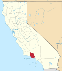 | |
| CDPs | ||
| Unincorporated communities | ||
| Footnotes | ‡This populated place also has portions in an adjacent county or counties | |
| Counties |  | |
|---|---|---|
| Cities and towns 100k-250k | ||
| Cities and towns 25k-100k | ||
| Cities and towns 10k-25k | ||
| Sub-regions | ||
Counties in italics sometimes included in the definition of the Central Coast | ||