Morgan County, Indiana
| Morgan County, Indiana | |
|---|---|
 Morgan County courthouse in Martinsville, Indiana | |
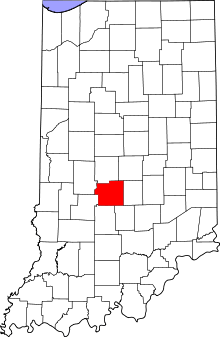 Location in the U.S. state of Indiana | |
 Indiana's location in the U.S. | |
| Founded | 1822 |
| Named for | Gen. Daniel Morgan |
| Seat | Martinsville |
| Largest city | Martinsville |
| Area | |
| • Total | 409.43 sq mi (1,060 km2) |
| • Land | 403.97 sq mi (1,046 km2) |
| • Water | 5.46 sq mi (14 km2), 1.33% |
| Population | |
| • (2010) | 68,894 |
| • Density | 169/sq mi (65.44/km²) |
| Congressional districts | 4th, 9th |
| Time zone | Eastern: UTC-5/-4 |
| Website | http://www.morgancounty.in.gov/ |
| Footnotes: Indiana county number 55 | |
Morgan County is a county located in the U.S. state of Indiana. As of 2010, the population was 68,894.[1] The county seat is Martinsville.[2]
Morgan County is located between Indianapolis, in Marion County, and Bloomington, located in Monroe County. It is included in the Indianapolis-Carmel-Anderson, IN Metropolitan Statistical Area. Two state highways, State Roads 37 and 67, carry large numbers of daily commuters between the two larger communities. The county is divided into 14 townships which provide local services.[3][4]
History
Morgan County was formed in 1822. It was named for Gen. Daniel Morgan, who defeated the British at the Battle of Cowpens in the Revolutionary War. In the late nineteenth and early twentieth centuries, mineral springs in Martinsville gave rise to several spas, and the nickname of the Martinsville High School athletic teams has subsequently been the Artesians. Settlers in Morgan County in the early nineteenth century came predominantly from southern states. The Mooresville area and surrounding communities received large numbers of southern Quakers, driven to migrate because of their opposition to slavery. Paul Hadley, a Mooresville resident, was the designer of the current Indiana flag, as well as a locally prominent water color artist in the early twentieth century.
County government took several steps forward in the 2000s, creating a new Plan Commission, re-instituting a county economic development organization, and establishing the county's first Park and Recreation Board between 2000 and 2004. Morgan County also was the first county in the metropolitan Indianapolis region to establish a smoking ban ordinance for restaurants, taking that step in 2004. Other communities in the region soon followed Morgan County's lead.
A County Achievement Award from the Association of Indiana Counties in 2006 was the third award from the group given to Morgan County in a ten-year span, adding to 1997 and 2003 awards.
In 2006 Morgan County was the first in the central Indiana region to offer a prescription drug discount program to its residents at no charge to individuals, helping residents save an average of 20% on prescriptions. Also during 2006, Morgan and Hendricks Counties became the first in Indiana to develop neighboring and co-related TIF (Tax Increment Financing) districts for economic development activity.
Morgan County has developed a new thoroughfare plan that is integrated with the Mooresville thoroughfare plan, and also recently completed a new capital improvement plan. Both activities are preludes to a new comprehensive plan being developed for the county.
Courthouse
The first building used for Morgan County courts was the log house of a pioneer. Work began in 1823 to build the first courthouse, a two story log house. A brick courthouse replaced it in 1833.[5]
The Morgan County courthouse was designed by Isaac Hodgson in the Italianate style. It was built from 1857 to 1859 by Perry M. Blankenship of Martinsville at a cost of $32,000. Originally it was almost identical to Hodgson's Jennings County courthouse in Vernon, which was also begun in 1857, but the Martinsville building received an addition in the 1970s; the original section was also remodeled and renovated at that time. The building is of red brick with white stone quoins and has tall windows with round arches, arranged in pairs. It is one of the few remaining pre-Civil War courthouses.[6]
Geography
According to the 2010 census, the county has a total area of 409.43 square miles (1,060.4 km2), of which 403.97 square miles (1,046.3 km2) (or 98.67%) is land and 5.46 square miles (14.1 km2) (or 1.33%) is water.[7] Morgan County is bisected by the White River Valley; the community has taken an interest in recent years in protecting the river as an asset, seeking to develop parks and greenways along the White River and initiating an annual river cleanup day in the spring.
The county also is home to large areas of land that were not glaciated during the last ice age. The river valley and contributing watersheds, along with the non-glaciated hills, results in a topography unlike the rest of the metropolitan Indianapolis area. County residents are proud of the scenic terrain, and in recent years have established a county park system and a bike/pedestrian trail system plan to provide protection and access to the amenities. An annual five mile (8 km) run ("Run to the Future", June 10, 2006) is held as a fundraiser for the path system endowment.
Incorporated Cities and towns
Unincorporated towns
- Centerton
- Cope
- Eminence
- Hall
- Waverly
- Wilbur
Townships
Major highways
- Expected around 2016.
Climate and weather
| Martinsville, Indiana | ||||||||||||||||||||||||||||||||||||||||||||||||||||||||||||
|---|---|---|---|---|---|---|---|---|---|---|---|---|---|---|---|---|---|---|---|---|---|---|---|---|---|---|---|---|---|---|---|---|---|---|---|---|---|---|---|---|---|---|---|---|---|---|---|---|---|---|---|---|---|---|---|---|---|---|---|---|
| Climate chart (explanation) | ||||||||||||||||||||||||||||||||||||||||||||||||||||||||||||
| ||||||||||||||||||||||||||||||||||||||||||||||||||||||||||||
| ||||||||||||||||||||||||||||||||||||||||||||||||||||||||||||
In recent years, average temperatures in Martinsville have ranged from a low of 18 °F (−8 °C) in January to a high of 85 °F (29 °C) in July, although a record low of −35 °F (−37 °C) was recorded in January 1994 and a record high of 105 °F (41 °C) was recorded in July 1954. Average monthly precipitation ranged from 2.44 inches (62 mm) in February to 4.73 inches (120 mm) in May.[8]
Government
The county government is a constitutional body granted specific powers by the Constitution of Indiana and the Indiana Code. The county council is the fiscal branch of the county government and controls all spending and revenue collection. Four Council members are elected from county districts, and three are elected at-large by the entire county electorate. The council members serve four-year terms and are responsible for setting salaries, the annual budget and special spending. The council also has limited authority to impose local taxes, in the form of optional income taxes and the property tax levy that is subject to state level approval, excise taxes and service taxes.[9][10]
The executive body of the county is made of a board of commissioners. The commissioners are elected county-wide, in staggered terms, and each serves a four-year term. One of the commissioners, typically the most senior, serves as president. The commissioners are charged with executing the acts legislated by the council, collecting revenue and managing day-to-day functions of the county government.[9][10]
The county maintains a small claims court that can handle some civil cases. The judge on the court is elected to a term of four years and must be a member of the Indiana Bar Association. The judge is assisted by a constable who is elected to a four-year term. In some cases, court decisions can be appealed to the state level circuit court.[10]
The county has several other elected offices, including sheriff, coroner, auditor, treasurer, recorder, surveyor and circuit court clerk. Each of these elected officers serves a term of four years and oversees a different part of county government. Members elected to county government positions are required to declare party affiliations and be residents of the county.[10]
Each of the townships has a trustee who administers rural fire protection and ambulance service, provides poor relief and manages cemetery care, among other duties.[4] The trustee is assisted in these duties by a three-member township board. The trustees and board members are elected to four-year terms.[11]
Morgan County is split between Indiana's 4th Congressional district and the 9th Congressional district; Indiana Senate districts 35 and 37;[12] and Indiana House of Representatives districts 47 and 91.[13]
Demographics
| Historical population | |||
|---|---|---|---|
| Census | Pop. | %± | |
| 1830 | 5,593 | — | |
| 1840 | 10,741 | 92.0% | |
| 1850 | 14,576 | 35.7% | |
| 1860 | 16,110 | 10.5% | |
| 1870 | 17,528 | 8.8% | |
| 1880 | 18,900 | 7.8% | |
| 1890 | 18,643 | −1.4% | |
| 1900 | 20,457 | 9.7% | |
| 1910 | 21,182 | 3.5% | |
| 1920 | 20,010 | −5.5% | |
| 1930 | 19,424 | −2.9% | |
| 1940 | 19,801 | 1.9% | |
| 1950 | 23,726 | 19.8% | |
| 1960 | 33,875 | 42.8% | |
| 1970 | 44,176 | 30.4% | |
| 1980 | 51,999 | 17.7% | |
| 1990 | 55,920 | 7.5% | |
| 2000 | 66,689 | 19.3% | |
| 2010 | 68,894 | 3.3% | |
| Est. 2015 | 69,648 | [14] | 1.1% |
| U.S. Decennial Census[15] 1790-1960[16] 1900-1990[17] 1990-2000[18] 2010-2013[1] | |||
As of the 2010 United States Census, there were 68,894 people, 25,765 households, and 19,355 families residing in the county.[19] The population density was 170.5 inhabitants per square mile (65.8/km2). There were 27,754 housing units at an average density of 68.7 per square mile (26.5/km2).[7] The racial makeup of the county was 97.7% white, 0.4% Asian, 0.3% American Indian, 0.3% black or African American, 0.3% from other races, and 1.0% from two or more races. Those of Hispanic or Latino origin made up 1.2% of the population.[19] In terms of ancestry, 46% of people in Morgan County were of English ancestry, 22.1% were of German ancestry, and 10.3% were of Irish ancestry. Of the 25,765 households, 35.8% had children under the age of 18 living with them, 59.8% were married couples living together, 10.1% had a female householder with no husband present, 24.9% were non-families, and 20.3% of all households were made up of individuals. The average household size was 2.65 and the average family size was 3.04. The median age was 39.9 years.[19]
The median income for a household in the county was $47,697 and the median income for a family was $62,507. Males had a median income of $48,457 versus $34,831 for females. The per capita income for the county was $23,972. About 7.2% of families and 10.1% of the population were below the poverty line, including 14.9% of those under age 18 and 6.8% of those age 65 or over.[20]
See also
References
- 1 2 "Morgan County QuickFacts". United States Census Bureau. Retrieved 2011-09-25.
- ↑ "Find a County – Morgan County, IN". National Association of Counties. Retrieved 2011-11-15.
- ↑ "Morgan". Indiana Township Association. Retrieved 2011-11-15.
- 1 2 "Duties". United Township Association of Indiana. Retrieved 2011-01-06.
- ↑ Blanchard, Charles (1884). Counties of Morgan, Monroe and Brown, Indiana: Historical and Biographical. F.A. Battey & Company. p. 19.
- ↑ Counts, Will; Jon Dilts (1991). The 92 Magnificent Indiana Courthouses. Bloomington, Indiana: Indiana University Press. pp. 116–7. ISBN 978-0-253-33638-5.
- 1 2 "Population, Housing Units, Area, and Density: 2010 - County". United States Census Bureau. Retrieved 2015-07-10.
- 1 2 "Monthly Averages for Martinsville, Indiana". The Weather Channel. Retrieved 2011-01-27.
- 1 2 Indiana Code. "Title 36, Article 2, Section 3". Government of Indiana. Retrieved 2008-09-16.
- 1 2 3 4 Indiana Code. "Title 2, Article 10, Section 2" (PDF). Government of Indiana. Retrieved 2008-09-16.
- ↑ "Government". United Township Association of Indiana. Retrieved 2011-01-06.
- ↑ "Indiana Senate Districts". State of Indiana. Retrieved 2011-07-14.
- ↑ "Indiana House Districts". State of Indiana. Retrieved 2011-07-14.
- ↑ "County Totals Dataset: Population, Population Change and Estimated Components of Population Change: April 1, 2010 to July 1, 2015". Retrieved July 2, 2016.
- ↑ "U.S. Decennial Census". United States Census Bureau. Retrieved July 10, 2014.
- ↑ "Historical Census Browser". University of Virginia Library. Retrieved July 10, 2014.
- ↑ "Population of Counties by Decennial Census: 1900 to 1990". United States Census Bureau. Retrieved July 10, 2014.
- ↑ "Census 2000 PHC-T-4. Ranking Tables for Counties: 1990 and 2000" (PDF). United States Census Bureau. Retrieved July 10, 2014.
- 1 2 3 "DP-1 Profile of General Population and Housing Characteristics: 2010 Demographic Profile Data". United States Census Bureau. Retrieved 2015-07-10.
- ↑ "DP03 SELECTED ECONOMIC CHARACTERISTICS – 2006-2010 American Community Survey 5-Year Estimates". United States Census Bureau. Retrieved 2015-07-10.
External links
 |
Putnam County | Hendricks County | Marion County | |
| |
Johnson County | |||
| ||||
| | ||||
| Owen County | Monroe County | Brown County |
Municipalities and communities of Morgan County, Indiana, United States | ||
|---|---|---|
| City | ||
| Towns | ||
| Townships | ||
| CDP | ||
| Other unincorporated communities |
| |
| Footnotes | ‡This populated place also has portions in an adjacent county or counties | |

Coordinates: 39°29′N 86°27′W / 39.48°N 86.45°W