Wynnedale, Indiana
| Wynnedale, Indiana | |
|---|---|
| Town | |
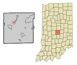 Location of Wynnedale in the state of Indiana | |
| Coordinates: 39°49′51″N 86°11′57″W / 39.83083°N 86.19917°WCoordinates: 39°49′51″N 86°11′57″W / 39.83083°N 86.19917°W | |
| Country | United States |
| State | Indiana |
| County | Marion |
| Township | Washington |
| Area[1] | |
| • Total | 0.16 sq mi (0.41 km2) |
| • Land | 0.16 sq mi (0.41 km2) |
| • Water | 0 sq mi (0 km2) |
| Elevation | 758 ft (231 m) |
| Population (2010)[2] | |
| • Total | 231 |
| • Estimate (2012[3]) | 234 |
| • Density | 1,443.8/sq mi (557.5/km2) |
| Time zone | Eastern (EST) (UTC-5) |
| • Summer (DST) | EDT (UTC-4) |
| ZIP code | 46228 |
| Area code(s) | 317 |
| FIPS code | 18-85742[4] |
| GNIS feature ID | 0446358[5] |
| Website |
www |
Wynnedale is a town in Washington Township, Marion County, Indiana. The population was 231 at the 2010 census.[6] It has existed as an "included town" since 1970, when it was incorporated into Indianapolis as part of Unigov. It is part of Indianapolis, but retains a functioning town government under IC 36-3-1-11.[7]
Geography
Wynnedale is located at 39°49′51″N 86°11′57″W / 39.83083°N 86.19917°W (39.830742, -86.199268).[8]
According to the 2010 census, Wynnedale has a total area of 0.16 square miles (0.41 km2), all land.[1]
Demographics
| Historical population | |||
|---|---|---|---|
| Census | Pop. | %± | |
| 1940 | 60 | — | |
| 1950 | 75 | 25.0% | |
| 1960 | 174 | 132.0% | |
| 1970 | 124 | −28.7% | |
| 1980 | 289 | 133.1% | |
| 1990 | 269 | −6.9% | |
| 2000 | 275 | 2.2% | |
| 2010 | 231 | −16.0% | |
| Est. 2015 | 239 | [9] | 3.5% |
2010 census
As of the census[2] of 2010, there were 231 people, 96 households, and 71 families residing in the town. The population density was 1,443.8 inhabitants per square mile (557.5/km2). There were 99 housing units at an average density of 618.8 per square mile (238.9/km2). The racial makeup of the town was 61.0% White, 35.9% African American, 1.3% Asian, 0.4% from other races, and 1.3% from two or more races. Hispanic or Latino of any race were 0.9% of the population.
There were 96 households of which 26.0% had children under the age of 18 living with them, 67.7% were married couples living together, 6.3% had a female householder with no husband present, and 26.0% were non-families. 21.9% of all households were made up of individuals and 13.5% had someone living alone who was 65 years of age or older. The average household size was 2.41 and the average family size was 2.83.
The median age in the town was 52.4 years. 19.9% of residents were under the age of 18; 1.3% were between the ages of 18 and 24; 14.2% were from 25 to 44; 39% were from 45 to 64; and 25.5% were 65 years of age or older. The gender makeup of the town was 48.1% male and 51.9% female.
2000 census
As of the census[4] of 2000, there were 275 people, 108 households, and 84 families residing in the town. The population density was 1,643.6 people per square mile (624.6/km²). There were 112 housing units at an average density of 669.4 per square mile (254.4/km²). The racial makeup of the town was 64.73% White, 33.09% African American, 0.36% Native American, 0.36% Asian, 1.45% from other races. Hispanic or Latino of any race were 1.45% of the population.
There were 108 households out of which 31.5% had children under the age of 18 living with them, 67.6% were married couples living together, 7.4% had a female householder with no husband present, and 22.2% were non-families. 20.4% of all households were made up of individuals and 8.3% had someone living alone who was 65 years of age or older. The average household size was 2.55 and the average family size was 2.82.
In the town the population was spread out with 21.1% under the age of 18, 3.6% from 18 to 24, 22.2% from 25 to 44, 32.7% from 45 to 64, and 20.4% who were 65 years of age or older. The median age was 48 years. For every 100 females there were 111.5 males. For every 100 females age 18 and over, there were 104.7 males.
The median income for a household in the town was $93,778, and the median income for a family was $101,931. Males had a median income of $80,969 versus $32,344 for females. The per capita income for the town was $50,323. None of the families and 0.9% of the population were living below the poverty line, including no under eighteens and 4.5% of those over 64.
References
- 1 2 "G001 - Geographic Identifiers - 2010 Census Summary File 1". United States Census Bureau. Retrieved 2015-07-25.
- 1 2 "American FactFinder". United States Census Bureau. Retrieved 2012-12-11.
- ↑ "Population Estimates". United States Census Bureau. Archived from the original on June 17, 2013. Retrieved 2013-06-25.
- 1 2 "American FactFinder". United States Census Bureau. Archived from the original on September 11, 2013. Retrieved 2008-01-31.
- ↑ "US Board on Geographic Names". United States Geological Survey. 2007-10-25. Retrieved 2008-01-31.
- ↑ "Profile of General Population and Housing Characteristics: 2010 Demographic Profile Data (DP-1): Wynnedale town, Indiana". U.S. Census Bureau, American Factfinder. Archived from the original on September 11, 2013. Retrieved February 14, 2012.
- ↑ Indiana Code 36-3-1
- ↑ "US Gazetteer files: 2010, 2000, and 1990". United States Census Bureau. 2011-02-12. Retrieved 2011-04-23.
- ↑ "Annual Estimates of the Resident Population for Incorporated Places: April 1, 2010 to July 1, 2015". Retrieved July 2, 2016.
- ↑ "Census of Population and Housing". Census.gov. Archived from the original on May 11, 2015. Retrieved June 4, 2015.
External links
Municipalities and communities of Marion County, Indiana, United States | ||
|---|---|---|
| Cities | ||
| Town | ||
| Townships | ||
| Included towns (see Unigov) | ||
| Footnotes | ‡This populated place also has portions in an adjacent county or counties | |