Avon, Indiana
| Avon, Indiana | |
|---|---|
| Town | |
| Town of Avon | |
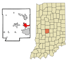 Location in the state of Indiana | |
| Coordinates: 39°45′47″N 86°23′16″W / 39.76306°N 86.38778°WCoordinates: 39°45′47″N 86°23′16″W / 39.76306°N 86.38778°W | |
| Country | United States |
| State | Indiana |
| County | Hendricks |
| Township | Washington |
| Area[1] | |
| • Total | 14.34 sq mi (37.14 km2) |
| • Land | 14.24 sq mi (36.88 km2) |
| • Water | 0.10 sq mi (0.26 km2) |
| Elevation[2] | 833 ft (254 m) |
| Population (2010)[3] | |
| • Total | 12,446 |
| • Estimate (2012)[4] | 13,306 |
| • Density | 874.0/sq mi (337.5/km2) |
| Time zone | EST (UTC-5) |
| • Summer (DST) | EDT (UTC-4) |
| ZIP code | 46123 |
| Area code | 317 |
| FIPS code[2][5] | 18-02908 |
| GNIS ID[2][5] | 430358 |
| Website |
www |
Avon is a town in Washington Township, Hendricks County, Indiana, United States. The population was 12,446 at the 2010 Census.
History
The first settlement at Avon was made around 1830.[6]
The first post office at Avon opened as Smootsdell, in 1868.[7] It was renamed Avon in 1870, and remained in operation until it was discontinued in 1902.[8]
Geography
Avon is located at 39°45′47″N 86°23′16″W / 39.76306°N 86.38778°W (39.763160, -86.387900).[9]
According to the 2010 census, Avon has a total area of 14.34 square miles (37.14 km2), of which 14.24 square miles (36.88 km2) (or 99.3%) is land and 0.1 square miles (0.26 km2) (or 0.7%) is water.[1] Avon is 4 miles (6.4 km) north to south.
Demographics
| Historical population | |||
|---|---|---|---|
| Census | Pop. | %± | |
| 2000 | 6,248 | — | |
| 2010 | 12,446 | 99.2% | |
| Est. 2015 | 16,451 | [10] | 32.2% |
2010 census
As of the 2010 census,[3] there were 12,446 people, 4,457 households, and 3,384 families residing in the town. The population density was 874.0 inhabitants per square mile (337.5/km2). There were 4,742 housing units at an average density of 333.0 per square mile (128.6/km2). The racial makeup of the town was 86.7% White, 5.9% Black, 0.3% Native American, 3.3% Asian, 0.1% Pacific Islander, 1.4% from other races, and 2.2% from two or more races. Hispanic or Latino of any race were 4.3% of the population.
There were 4,457 households of which 45.6% had children under the age of 18 living with them, 62.5% were married couples living together, 9.3% had a female householder with no husband present, 4.1% had a male householder with no wife present, and 24.1% were non-families. 19.4% of all households were made up of individuals and 5.8% had someone living alone who was 65 years of age or older. The average household size was 2.77 and the average family size was 3.20.
The median age in the town was 33.9 years. 30.2% of residents were under the age of 18; 6.6% were between the ages of 18 and 24; 31.7% were from 25 to 44; 23.6% were from 45 to 64; and 8% were 65 years of age or older. The gender makeup of the town was 48.3% male and 51.7% female.
2000 census
As of the 2000 census,[12] there were 6,248 people, 2,127 households, and 1,786 families residing in the town. The population density was 976.2 people per square mile (378.1/km²). There were 2,240 housing units at an average density of 351.1 per square mile (135.6/km²). The racial makeup of the town was 95.87% White, 0.58% Black, 0.26% Native American, 1.41% Asian, 0.06% Pacific Islander, 0.72% from other races, and 1.10% from two or more races. Hispanic or Latino of any race were 1.36% of the population.
There were 2,127 households out of which 51.4% had children under the age of 18 living with them, 75.4% were married couples living together, 5.6% had a female householder with no husband present, and 16.0% were non-families. 12.6% of all households were made up of individuals and 3.6% had someone living alone who was 65 years of age or older. The average household size was 2.94 and the average family size was 3.22.
In the town the population was spread out with 33.2% under the age of 18, 4.8% from 18 to 24, 39.3% from 25 to 44, 18.1% from 45 to 64, and 4.5% who were 65 years of age or older. The median age was 32 years. For every 100 females there were 101.7 males. For every 100 females age 18 and over, there were 99.0 males.
The median income for a household in the town was $66,782, and the median income for a family was $68,205. Males had a median income of $48,542 versus $31,010 for females. The per capita income for the town was $24,740. About 2.7% of families and 2.9% of the population were below the poverty line, including 2.9% of those under age 18 and 15.8% of those age 65 or over.
Education
Public schools
Avon's public school system is the Avon Community School Corporation. The mascot is the Avon Oriole.
Schools in the system include:
- High Schools (grades 9-12)
- Avon High School
- Harris Academy (shared with Brownsburg schools)
- Middle Schools (grades 7-8)
- Avon Middle School - North
- Avon Middle School - South
- Intermediate Schools (grades 5-6)
- Avon Intermediate School - East
- Avon Intermediate School - West
- Elementary Schools (grades K-4)
- Cedar Elementary School
- Hickory Elementary School
- Maple Elementary School
- Pine Tree Elementary School
- River Birch Elementary School
- Sycamore Elementary School
- White Oak Elementary School
Marching band
The Avon High School marching band is well known throughout the country. The Avon Marching Black and Gold, led by Jay Webb, Matt Harloff, and Robert Burns, was ranked number one in the state of Indiana by the Indiana State School Music Association (ISSMA) seven years in a row (two times in Class B, five times in Class A).[13] The winning streak ended during the ISSMA state championship on November 1, 2008 when they placed second.[13] They again placed first in Class A on October 31, 2009 and on October 30, 2010, marking their ninth state championship in only ten years.[13] On November 15, 2008, they were ranked as the best high school marching band in the country, placing first during Bands of America Grand Nationals for the first time in the school's history. They won again in 2009 and 2010, making them the first band to win three years in a row since Marian Catholic in 1989. In 2011, they placed 2nd.[14][15]
Private schools
Private schools:
- Kingsway Christian School (grades K-8)
- Our Shepherd Lutheran School (grades PK-8)
Notable people
- Larry Dixon - Drag racer
- Jay Drake - Former race car driver
- Chet Fillip - Race car driver
- Sergio Gomez - Singer
- Andrew Hines - Drag racer
- William T. Hornaday - Zoologist, savior of the Bison
- Jim Sorgi - Indianapolis Colts and New York Giants NFL quarterback
- Steve Talley - Actor
- Bill Vukovich, Jr. - Former race car driver
- Patrick Rogers - Professional Golfer, PGA
- Jared Miller - Pitcher, Arizona Diamondbacks MLB
Neighboring communities
 |
Pittsboro | Brownsburg | | |
| Danville | |
Indianapolis | ||
| ||||
| | ||||
| Clayton | Plainfield |
References
- 1 2 "G001 - Geographic Identifiers - 2010 Census Summary File 1". United States Census Bureau. Retrieved 2015-07-13.
- 1 2 3 "Feature ID 430358". Geographic Names Information System. United States Geological Survey. Retrieved June 30, 2014.
- 1 2 "American FactFinder". United States Census Bureau. Retrieved 2012-12-11.
- ↑ "Incorporated Places and Minor Civil Divisions Datasets: Subcounty Resident Population Estimates: April 1, 2010 to July 1, 2012". United States Census Bureau. Archived from the original on 2013-06-17. Retrieved 2013-06-25.
- 1 2 "FIPS55 Data: Indiana". FIPS55 Data. United States Geological Survey. February 23, 2006. Archived from the original on June 18, 2006. Retrieved June 30, 2014. External link in
|work=(help) - ↑ Hadley, John Vestal (1914). History of Hendricks County, Indiana: Her People, Industries and Institutions. B.F. Bowen & Company, Incorporated. p. 101.
- ↑ Baker, Ronald L. (October 1995). From Needmore to Prosperity: Hoosier Place Names in Folklore and History. Indiana University Press. p. 57. ISBN 978-0-253-32866-3.
A post office was established as Smootsdell, for John Smoot, on April 17, 1868.
- ↑ "Hendricks County". Jim Forte Postal History. Retrieved 20 September 2014.
- ↑ "US Gazetteer files: 2010, 2000, and 1990". United States Census Bureau. 2011-02-12. Retrieved 2011-04-23.
- ↑ "Annual Estimates of the Resident Population for Incorporated Places: April 1, 2010 to July 1, 2015". Retrieved July 2, 2016.
- ↑ "Census of Population and Housing". Census.gov. Archived from the original on May 11, 2015. Retrieved June 4, 2015.
- ↑ "American FactFinder". United States Census Bureau. Archived from the original on 2013-09-11. Retrieved 2008-01-31.
- 1 2 3 "Marching Band State Finals Results: 1973 - 2013". Indiana State School Music Association. Retrieved June 30, 2014.
- ↑ "Bands of America 2008 Finals Results". Music for All, Inc. Archived from the original on December 12, 2008.
- ↑ "Bands of America Marching Championships - Results 2009 - 2013". Music for All, Inc. Retrieved June 30, 2014.
External links
| Wikivoyage has a travel guide for Avon (Indiana). |
- Avon-Washington Township Public Library
- Avon, Indiana Chamber of Commerce website
- Town of Avon, Indiana website
- Avon Community School Corporation
- Hendricks County Convention and Visitors Bureau
Municipalities and communities of Hendricks County, Indiana, United States | ||
|---|---|---|
| Towns | ||
| Townships | ||
| Unincorporated communities |
| |
| Footnotes | ‡This populated place also has portions in an adjacent county or counties | |