Cumberland, Indiana
| Town of Cumberland, Indiana | |
|---|---|
| Town | |
|
A residential neighborhood in northern Cumberland | |
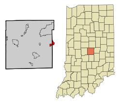 Location in the state of Indiana | |
| Coordinates: 39°47′1″N 85°57′8″W / 39.78361°N 85.95222°WCoordinates: 39°47′1″N 85°57′8″W / 39.78361°N 85.95222°W | |
| Country | United States |
| State | Indiana |
| Counties | Marion, Hancock |
| Area[1] | |
| • Total | 2.07 sq mi (5.36 km2) |
| • Land | 2.06 sq mi (5.34 km2) |
| • Water | 0.01 sq mi (0.03 km2) |
| Elevation | 853 ft (260 m) |
| Population (2010)[2] | |
| • Total | 5,169 |
| • Estimate (2012[3]) | 5,207 |
| • Density | 2,509.2/sq mi (968.8/km2) |
| Time zone | EST (UTC-5) |
| • Summer (DST) | EST (UTC-5) |
| ZIP code | 46229 |
| Area code(s) | 317 |
| FIPS code | 18-16336[4] |
| GNIS feature ID | 0433243[5] |
| Website | http://www.town.cumberland.in.us |

Cumberland is a town located in Hancock and Marion counties, Indiana, United States. The population was 5,169 at the 2010 census.
History
Cumberland was founded in the 1830s when the Cumberland Road (also known as the National Road) was extended to that point.[6][7] Cumberland contained a post office from 1834 until it was discontinued in 1958.[8]
Geography
Cumberland is located at 39°47′1″N 85°57′8″W / 39.78361°N 85.95222°W (39.783528, -85.952308).[9]
According to the 2010 census, the town has a total area of 2.07 square miles (5.4 km2), of which 2.06 square miles (5.3 km2) (or 99.52%) is land and 0.01 square miles (0.026 km2) (or 0.48%) is water.[10]
Demographics
| Historical population | |||
|---|---|---|---|
| Census | Pop. | %± | |
| 1880 | 299 | — | |
| 1960 | 872 | — | |
| 1970 | 1,478 | 69.5% | |
| 1980 | 3,375 | 128.3% | |
| 1990 | 4,557 | 35.0% | |
| 2000 | 5,500 | 20.7% | |
| 2010 | 5,169 | −6.0% | |
| Est. 2015 | 5,467 | [11] | 5.8% |
2010 census
As of the census[2] of 2010, there were 5,169 people, 1,972 households, and 1,422 families residing in the town. The population density was 2,509.2 inhabitants per square mile (968.8/km2). There were 2,233 housing units at an average density of 1,084.0 per square mile (418.5/km2). The racial makeup of the town was 77.0% White, 16.8% African American, 0.6% Native American, 0.9% Asian, 0.1% Pacific Islander, 2.3% from other races, and 2.3% from two or more races. Hispanic or Latino of any race were 5.3% of the population.
There were 1,972 households of which 36.4% had children under the age of 18 living with them, 50.3% were married couples living together, 16.6% had a female householder with no husband present, 5.2% had a male householder with no wife present, and 27.9% were non-families. 23.1% of all households were made up of individuals and 6.8% had someone living alone who was 65 years of age or older. The average household size was 2.61 and the average family size was 3.05.
The median age in the town was 38.4 years. 27.4% of residents were under the age of 18; 7.8% were between the ages of 18 and 24; 24% were from 25 to 44; 29.3% were from 45 to 64; and 11.5% were 65 years of age or older. The gender makeup of the town was 48.1% male and 51.9% female.
2000 census
As of the census[4] of 2000, there were 5,500 people, 2,030 households, and 1,565 families residing in the town. The population density was 2,907.0 people per square mile (1,123.6/km²). There were 2,190 housing units at an average density of 1,157.5 per square mile (447.4/km²). The racial makeup of the town was 85.20% White, 10.56% African American, 0.22% Native American, 1.76% Asian, 0.04% Pacific Islander, 0.75% from other races, and 1.47% from two or more races. Hispanic or Latino of any race were 1.45% of the population.
There were 2,030 households out of which 40.6% had children under the age of 18 living with them, 59.3% were married couples living together, 14.6% had a female householder with no husband present, and 22.9% were non-families. 19.1% of all households were made up of individuals and 5.7% had someone living alone who was 65 years of age or older. The average household size was 2.70 and the average family size was 3.08.
In the town the population was spread out with 30.0% under the age of 18, 7.1% from 18 to 24, 29.9% from 25 to 44, 24.4% from 45 to 64, and 8.6% who were 65 years of age or older. The median age was 34 years. For every 100 females there were 92.5 males. For every 100 females age 18 and over, there were 88.1 males.
The median income for a household in the town was $57,875, and the median income for a family was $61,739. Males had a median income of $48,750 versus $28,239 for females. The per capita income for the town was $24,746. About 5.0% of families and 6.6% of the population were below the poverty line, including 12.2% of those under age 18 and 1.5% of those age 65 or over.
References
- ↑ "US Gazetteer files 2010". United States Census Bureau. Archived from the original on 2012-01-24. Retrieved 2012-12-11.
- 1 2 "American FactFinder". United States Census Bureau. Retrieved 2012-12-11.
- ↑ "Population Estimates". United States Census Bureau. Archived from the original on 2013-06-17. Retrieved 2013-06-25.
- 1 2 "American FactFinder". United States Census Bureau. Archived from the original on 2013-09-11. Retrieved 2008-01-31.
- ↑ "US Board on Geographic Names". United States Geological Survey. 2007-10-25. Retrieved 2008-01-31.
- ↑ Baker, Ronald L. (October 1995). From Needmore to Prosperity: Hoosier Place Names in Folklore and History. Indiana University Press. p. 107. ISBN 978-0-253-32866-3.
...and named for the Cumberland Road, on which it was located.
- ↑ Bodenhamer, David J.; Barrows, Robert G. (22 November 1994). The Encyclopedia of Indianapolis. Indiana University Press. p. 133. ISBN 0-253-11249-4.
- ↑ "Marion County". Jim Forte Postal History. Archived from the original on 18 January 2015. Retrieved 18 January 2015.
- ↑ "US Gazetteer files: 2010, 2000, and 1990". United States Census Bureau. 2011-02-12. Retrieved 2011-04-23.
- ↑ "2010 Census U.S. Gazetteer Files for Places – Indiana". United States Census. Retrieved 2012-04-21.
- ↑ "Annual Estimates of the Resident Population for Incorporated Places: April 1, 2010 to July 1, 2015". Retrieved July 2, 2016.
- ↑ "Census of Population and Housing". Census.gov. Archived from the original on May 11, 2015. Retrieved June 4, 2015.
External links
Municipalities and communities of Hancock County, Indiana, United States | ||
|---|---|---|
| City | ||
| Towns | ||
| Townships | ||
| Unincorporated communities |
| |
| Footnotes | ‡This populated place also has portions in an adjacent county or counties | |
Municipalities and communities of Marion County, Indiana, United States | ||
|---|---|---|
| Cities | ||
| Town | ||
| Townships | ||
| Included towns (see Unigov) | ||
| Footnotes | ‡This populated place also has portions in an adjacent county or counties | |