Boone County, Indiana
| Boone County, Indiana | |
|---|---|
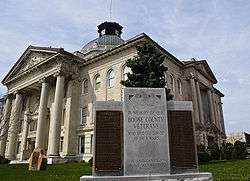 Boone County courthouse in Lebanon, Indiana | |
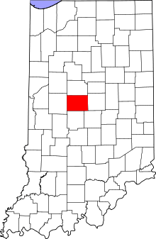 Location in the U.S. state of Indiana | |
 Indiana's location in the U.S. | |
| Founded | 1 April 1830 |
| Named for | Daniel Boone |
| Seat | Lebanon |
| Largest city | Lebanon |
| Area | |
| • Total | 423.25 sq mi (1,096 km2) |
| • Land | 422.91 sq mi (1,095 km2) |
| • Water | 0.34 sq mi (1 km2), 0.08% |
| Population | |
| • (2010) | 56,640 |
| • Density | 134/sq mi (51.72/km²) |
| Congressional districts | 4th, 5th |
| Website |
boonecounty |
| Footnotes: Indiana county number 6 | |
Boone County is a county located in the U.S. state of Indiana. As of 2010, the population was 56,640.[1] The county seat is Lebanon.[2] Indiana's center of population is located in eastern Boone County, just northwest of the town of Sheridan in neighboring Hamilton County.[3]
History
Boone County was formed April 1, 1830, and named for frontiersman Daniel Boone.[4] The county commissioners met near the center of the county on May 1, 1831 to identify a county seat, which by law had to be within 2 miles (3.2 km) of the county's center; the city of Lebanon was selected to serve this purpose, replacing Jamestown (Founded 1830) which had served as interim county seat.[5]
Geography
According to the 2010 census, the county has a total area of 423.25 square miles (1,096.2 km2), of which 422.91 square miles (1,095.3 km2) (or 99.92%) is land and 0.34 square miles (0.88 km2) (or 0.08%) is water.[6]
Adjacent counties
- Clinton County (north)
- Hamilton County (east)
- Marion County (southeast)
- Hendricks County (south)
- Montgomery County (west)
Cities and towns
Unincorporated towns
Extinct towns
- Ratsburg
- Ward
Townships
Major highways
 Interstate 65
 Interstate 74
 Interstate 465
 Interstate 865
 U.S. Route 52
 U.S. Route 136
 U.S. Route 421
 Indiana State Road 32
 Indiana State Road 39
 Indiana State Road 47
 Indiana State Road 75
 Indiana State Road 234
 Indiana State Road 267
 Indiana State Road 334
Airport
Railroads
Education
Public schools in Boone County are administered by the Lebanon Community School Corporation, the Western Boone County Community School District and Zionsville Community Schools.
Climate and weather
| Lebanon, Indiana | ||||||||||||||||||||||||||||||||||||||||||||||||||||||||||||
|---|---|---|---|---|---|---|---|---|---|---|---|---|---|---|---|---|---|---|---|---|---|---|---|---|---|---|---|---|---|---|---|---|---|---|---|---|---|---|---|---|---|---|---|---|---|---|---|---|---|---|---|---|---|---|---|---|---|---|---|---|
| Climate chart (explanation) | ||||||||||||||||||||||||||||||||||||||||||||||||||||||||||||
| ||||||||||||||||||||||||||||||||||||||||||||||||||||||||||||
| ||||||||||||||||||||||||||||||||||||||||||||||||||||||||||||
In recent years, average temperatures in Lebanon have ranged from a low of 18 °F (−8 °C) in January to a high of 86 °F (30 °C) in July, although a record low of −27 °F (−33 °C) was recorded in January 1994 and a record high of 112 °F (44 °C) was recorded in July 1936. Average monthly precipitation ranged from 2.35 inches (60 mm) in February to 4.54 inches (115 mm) in July.[7]
Government
The county government is a constitutional body, and is granted specific powers by the Constitution of Indiana, and by the Indiana Code.
County Council: The county council is the legislative branch of the county’s government and controls all the spending and revenue collection in the county. Representatives are elected from county districts. The council members serve four-year terms. They are responsible for setting salaries, the annual budget, and special spending. The council also has limited authority to impose local taxes, in the form of an income and property tax that is subject to state level approval, excise taxes, and service taxes.[8][9]
Board of Commissioners: The executive body of the county is made up of a board of commissioners. The commissioners are elected county-wide, in staggered terms, and each serves a four-year term. One of the commissioners, typically the most senior, serves as president. The commissioners are charged with executing the acts legislated by the council, collecting revenue, and managing the day-to-day functions of the county government.[8][9]
Court: The county maintains a small claims court that can handle some civil cases. The judge on the court is elected to a term of four years and must be a member of the Indiana Bar Association. The judge is assisted by a constable who is also elected to a four-year term. In some cases, court decisions can be appealed to the state level circuit court.[9]
County Officials: The county has several other elected offices, including sheriff, coroner, auditor, treasurer, recorder, surveyor, and circuit court clerk. Each of these elected officers serves a term of four years and oversees a different part of county government. Members elected to county government positions are required to declare a party affiliation and to be residents of the county.[9]
Boone County is part of Indiana's 4th congressional district, Indiana Senate districts 21 and 23,[10] and Indiana House of Representatives districts 28, 38 and 87.[11]
Demographics
| Historical population | |||
|---|---|---|---|
| Census | Pop. | %± | |
| 1830 | 621 | — | |
| 1840 | 8,121 | 1,207.7% | |
| 1850 | 11,631 | 43.2% | |
| 1860 | 16,753 | 44.0% | |
| 1870 | 22,593 | 34.9% | |
| 1880 | 25,922 | 14.7% | |
| 1890 | 26,572 | 2.5% | |
| 1900 | 26,321 | −0.9% | |
| 1910 | 24,673 | −6.3% | |
| 1920 | 23,575 | −4.5% | |
| 1930 | 22,290 | −5.5% | |
| 1940 | 22,081 | −0.9% | |
| 1950 | 23,993 | 8.7% | |
| 1960 | 27,543 | 14.8% | |
| 1970 | 30,870 | 12.1% | |
| 1980 | 36,446 | 18.1% | |
| 1990 | 38,147 | 4.7% | |
| 2000 | 46,107 | 20.9% | |
| 2010 | 56,640 | 22.8% | |
| Est. 2015 | 63,344 | [12] | 11.8% |
| U.S. Decennial Census[13] 1790-1960[14] 1900-1990[15] 1990-2000[16] 2010-2013[1] | |||
As of the 2010 United States Census, there were 56,640 people, 21,149 households, and 15,509 families residing in the county.[17] The population density was 133.9 inhabitants per square mile (51.7/km2). There were 22,754 housing units at an average density of 53.8 per square mile (20.8/km2).[6] The racial makeup of the county was 95.3% white, 1.7% Asian, 0.9% black or African American, 0.2% American Indian, 0.7% from other races, and 1.4% from two or more races. Those of Hispanic or Latino origin made up 2.2% of the population.[17] In terms of ancestry, 28.9% were German, 19.3% were English, 14.1% were Irish, and 9.0% were American.[18]
Of the 21,149 households, 38.8% had children under the age of 18 living with them, 61.1% were married couples living together, 8.4% had a female householder with no husband present, 26.7% were non-families, and 22.4% of all households were made up of individuals. The average household size was 2.65 and the average family size was 3.12. The median age was 38.6 years.[17]
The median income for a household in the county was $47,697 and the median income for a family was $81,401. Males had a median income of $57,251 versus $41,309 for females. The per capita income for the county was $38,696. About 6.1% of families and 7.1% of the population were below the poverty line, including 8.6% of those under age 18 and 5.6% of those age 65 or over.[19]
See also
- List of public art in Boone County, Indiana
- National Register of Historic Places listings in Boone County, Indiana
References
- 1 2 "Boone County QuickFacts". United States Census Bureau. Retrieved 2011-09-17.
- ↑ "Find a County". National Association of Counties. Archived from the original on 2011-05-31. Retrieved 2011-06-07.
- ↑ "Population and Population Centers by State: 2000". United States Census. Archived from the original on 2013-06-22. Retrieved 2007-06-30.
- ↑ Harden and Spahr 1887, p. 10.
- ↑ Harden and Spahr 1887, p. 37.
- 1 2 "Population, Housing Units, Area, and Density: 2010 - County". United States Census Bureau. Retrieved 2015-07-10.
- 1 2 "Monthly Averages for Lebanon, Indiana". The Weather Channel. Retrieved 2011-01-27.
- 1 2 Indiana Code. "Title 36, Article 2, Section 3". IN.gov. Retrieved 2008-09-16.
- 1 2 3 4 Indiana Code. "Title 2, Article 10, Section 2" (PDF). IN.gov. Retrieved 2008-09-16.
- ↑ "Indiana Senate Districts". State of Indiana. Retrieved 2011-01-23.
- ↑ "Indiana House Districts". State of Indiana. Retrieved 2011-01-23.
- ↑ "County Totals Dataset: Population, Population Change and Estimated Components of Population Change: April 1, 2010 to July 1, 2015". Retrieved July 2, 2016.
- ↑ "U.S. Decennial Census". United States Census Bureau. Archived from the original on May 11, 2015. Retrieved July 10, 2014.
- ↑ "Historical Census Browser". University of Virginia Library. Retrieved July 10, 2014.
- ↑ "Population of Counties by Decennial Census: 1900 to 1990". United States Census Bureau. Retrieved July 10, 2014.
- ↑ "Census 2000 PHC-T-4. Ranking Tables for Counties: 1990 and 2000" (PDF). United States Census Bureau. Retrieved July 10, 2014.
- 1 2 3 "DP-1 Profile of General Population and Housing Characteristics: 2010 Demographic Profile Data". United States Census Bureau. Retrieved 2015-07-10.
- ↑ "DP02 SELECTED SOCIAL CHARACTERISTICS IN THE UNITED STATES – 2006-2010 American Community Survey 5-Year Estimates". United States Census Bureau. Retrieved 2015-07-10.
- ↑ "DP03 SELECTED ECONOMIC CHARACTERISTICS – 2006-2010 American Community Survey 5-Year Estimates". United States Census Bureau. Retrieved 2015-07-10.
Bibliography
- Harden, Samuel; Spahr, John (1887). Early Life and Times in Boone County, Indiana. Indianapolis: Carlon and Hollenbeck. Retrieved 2011-05-31.
- Leander Mead, Crist. History of Boone County, Indiana. Indianapolis: A. W. Bowen and Company. Retrieved 2011-05-31.
External links
- Boone County Community Network
- Lebanon Community School Corporation
- Western Boone County Community School Dist
- Zionsville Community Schools
- Boone County Government
 |
Clinton County | | ||
| Montgomery County | |
Hamilton County | ||
| ||||
| | ||||
| Hendricks County | Marion County |
Municipalities and communities of Boone County, Indiana, United States | ||
|---|---|---|
| City | ||
| Towns | ||
| Townships | ||
| Unincorporated communities |
| |
| Footnotes | ‡This populated place also has portions in an adjacent county or counties | |

Coordinates: 40°03′N 86°28′W / 40.05°N 86.47°W