Schererville, Indiana
| Town of Schererville, Indiana | |
|---|---|
| Town | |
 | |
|
Nickname(s): Crossroads of America, The Region | |
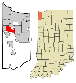 Schererville's location in Lake County (left) and the state of Indiana (right). | |
| Coordinates: 41°29′21″N 87°26′35″W / 41.48917°N 87.44306°WCoordinates: 41°29′21″N 87°26′35″W / 41.48917°N 87.44306°W | |
| Country |
|
| State |
|
| County | Lake |
| Township | St. John |
| Founded | 1866 |
| Named for | Nicholas Scherer |
| Government[1] | |
| • Type | Town |
| • Body | Town Council |
| • President | Michael A. Troxell (D, 5th) |
| • Members: |
Jerry Tippy (R, 1st) Kevin Connelly (R, 2nd) Bob Guetzloff (D, 3rd) Tom Schmitt (D, 4th) |
| • Clerk-Treasurer | Janice M. Malinowski (D) |
| • Judge | Kenneth J. Anderson (D) |
| • Town Manager | Robert Volkmann |
| Area[2] | |
| • Total | 14.76 sq mi (38.2 km2) |
| • Land | 14.71 sq mi (38.1 km2) |
| • Water | 0.05 sq mi (0.1 km2) |
| Elevation | 669 ft (204 m) |
| Population (2010)[3] | |
| • Total | 29,243 |
| • Estimate (2013) | 29,010 |
| • Density | 1,988.0/sq mi (767.6/km2) |
| Standard of living (2008-12)[3] | |
| • Per capita income | $33,984 |
| • Median home value | $204,300 |
| Time zone | Central (UTC-6) |
| • Summer (DST) | Central (UTC-5) |
| ZIP code | 46375 |
| Area code | 219 |
| FIPS code | 18-68220[4] |
| GNIS feature ID | 0443066[5] |
| Website |
www |
| Demographics (2010)[6] | |||
|---|---|---|---|
| White | Black | Asian | |
| 86.8% | 5.4% | 2.8% | |
| Islander | Native | Other | Hispanic (any race) |
| 0.0% | 0.2% | 4.8% | 10.6% |
| Historical population | |||
|---|---|---|---|
| Census | Pop. | %± | |
| 1920 | 483 | — | |
| 1930 | 580 | 20.1% | |
| 1940 | 998 | 72.1% | |
| 1950 | 1,457 | 46.0% | |
| 1960 | 2,875 | 97.3% | |
| 1970 | 3,663 | 27.4% | |
| 1980 | 13,209 | 260.6% | |
| 1990 | 19,926 | 50.9% | |
| 2000 | 24,851 | 24.7% | |
| 2010 | 29,243 | 17.7% | |
| Est. 2015 | 28,791 | [7] | −1.5% |
| Source: US Census Bureau | |||
Schererville is a town in St. John Township, Lake County, Indiana, United States. It is part of the Chicago metropolitan area. The population was 29,243 at the 2010 census.
History
Long before Indiana became a state, long before the founding of Schererville, people called the area the "Crossroads," as several Native American trails intersected here, that later became routes for the wagons of settlers traveling west.
One of those settlers was Nicholas Scherer, born in 1807 at Dilsburg, today part of Heusweiler district, Saarland, southwest Germany, who arrived in the U.S. in 1846. When he came to this place at the southern tip of Lake Michigan in 1865, he founded the community that bears his name.[8]
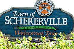
Today, trails still cross at Schererville, the modern trails of a motorized society, U.S. Highways 41 and 30. Nearby are newer trails, I-80/94 and I-65. All these are primary transcontinental routes and gives Schererville its slogan: "Crossroads of the Nation."
Since the 1990s, Schererville has attracted many former Illinois residents. The town's strategic location, reasonable housing costs, and high level of municipal services have contributed to its growth in recent years.
The town was named one of the "100 Best Places to Live in the U.S." by Money Magazine in 2007.
Schererville's former Town Council President, Perry Ferrini, died on December 13, 2009. The Town Council's new president became Jerry Tippy, and the vacant seat held by Perry was filled by Sharon Moore on January 9, 2010.
The town of Schererville celebrated its sesquicentennial in September, 2016.
Geography
Schererville is located at 41°29′21″N 87°26′35″W / 41.48917°N 87.44306°W (41.489135, -87.443137).[9]
According to the 2010 census, Schererville has a total area of 14.763 square miles (38.24 km2), of which 14.71 square miles (38.10 km2) (or 99.64%) is land and 0.053 square miles (0.14 km2) (or 0.36%) is water.[2]
One of Schererville's neighborhoods, Briar Ridge, spans both Schererville and adjacent Dyer. The ridge south of Route 30 is the Glenwood Shoreline.
Many residents of Schererville commute to work in downtown Chicago due to the city's proximity.
Demographics
2010 census
As of the census[3] of 2010, there were 29,243 people, 11,883 households, and 7,981 families residing in the town. The population density was 1,988.0 inhabitants per square mile (767.6/km2). There were 12,393 housing units at an average density of 842.5 per square mile (325.3/km2). The racial makeup of the town was 86.8% White, 5.4% African American, 0.2% Native American, 2.8% Asian, 2.9% from other races, and 1.8% from two or more races. Hispanic or Latino of any race were 10.6% of the population.
There were 11,883 households of which 29.8% had children under the age of 18 living with them, 53.3% were married couples living together, 9.7% had a female householder with no husband present, 4.2% had a male householder with no wife present, and 32.8% were non-families. 27.7% of all households were made up of individuals and 9.2% had someone living alone who was 65 years of age or older. The average household size was 2.45 and the average family size was 3.03.
The median age in the town was 40.9 years. 22.1% of residents were under the age of 18; 7.7% were between the ages of 18 and 24; 25.9% were from 25 to 44; 30.3% were from 45 to 64; and 14% were 65 years of age or older. The gender makeup of the town was 48.5% male and 51.5% female.
As of 2010, the median income for a household in the town was $66,160 while the mean income for a household in the town was $77,738. The median income for a family was $84,507 and the mean income for a family was $92,404. The estimated per capita income for the town was $31,983. About 4.3% of families and 7.1% of the population were estimated to be below the poverty line.[10]
2000 census
As of the census[4] of 2000, there were 24,851 people, 9,660 households, and 6,829 families residing in the town. The population density was 1,825.9 people per square mile (705.0/km²). There were 10,006 housing units at an average density of 735.2/sq mi (283.9/km²). The racial makeup of the town was 91.45% White, 2.14% African American, 0.11% Native American, 2.56% Asian, 0.04% Pacific Islander, 2.03% from other races, and 1.66% from two or more races. Hispanic or Latino of any race were 6.34% of the population.
There were 9,660 households out of which 32.6% had children under the age of 18 living with them, 59.0% were married couples living together, 8.3% had a female householder with no husband present, and 29.3% were non-families. 24.2% of all households were made up of individuals and 6.5% had someone living alone who was 65 years of age or older. The average household size was 2.56 and the average family size was 3.08.
In the town the population was spread out with 24.3% under the age of 18, 8.7% from 18 to 24, 30.6% from 25 to 44, 26.1% from 45 to 64, and 10.4% who were 65 years of age or older. The median age was 37 years. For every 100 females there were 96.7 males. For every 100 females age 18 and over, there were 92.9 males.
The median income for a household in the town was $59,243, and the median income for a family was $70,474. Males had a median income of $50,732 versus $30,745 for females. The per capita income for the town was $28,528. About 1.4% of families and 3.1% of the population were below the poverty line, including 1.9% of those under age 18 and 2.2% of those age 65 or over.
Education
Schererville is served by the Lake Central School Corporation, which also services the adjacent towns of St. John and Dyer.
List of schools - Lake Central School Corporation:
- Lake Central High School (St.John)
- Grimmer Middle School
- Kahler Middle School (Dyer)
- Clark Middle School (St. John)
- Peifer Elementary
- Bibich Elementary (Dyer)
- Kolling Elementary (St. John)
- Homan Elementary
- Protsman Elementary (Dyer)
- Watson Elementary
Private schools in the town include St. Michael School and the Forest Ridge Academy. The campus of Hammond Baptist Schools, affiliated with the First Baptist Church of Hammond, is also located in Schererville. Other private schools Schererville residents attend include Andrean High School (Merrillville), Bishop Noll Institute (Hammond), St. John Evangelist School (St. John), Illiana Christian High School (Lansing, IL), Marian Catholic High School (Chicago Heights, IL), and Mount Carmel High School (Chicago, IL)
Public libraries
Lake County Public Library operates the Dyer-Schererville Branch, which also serves Dyer, at 1001 West Lincoln Highway in Schererville.[11]
Newspaper
Schererville is served by The Times of Northwest Indiana, and The Post-Tribune, which is owned by the Chicago Tribune.
Recreational sports
The Schererville Soccer Club provides a soccer environment for boys and girls ages 4–17 (U6 through REC Plus.)[12]
There is also Tri-Town Football for ages going all the way to 15 or 16 years of age.
Transportation
The closest commercial airport to Schererville is the Gary/Chicago International Airport in Gary, but most Schererville residents and visitors fly via Chicago's O'Hare International or Midway.[13]
Schererville is situated at the crossroads of US 30 and US 41. The Borman Expressway (I-80/94/US 6), the Indiana Toll Road, Interstate 65, US 12 and US 20 are within a 25-mile (40 km) radius of Schererville.
References
- ↑ "2014 Public Officials Directory". Lake County Board of Elections and Voter's Registration. Retrieved 2014-06-10.
- 1 2 "G001 - Geographic Identifiers - 2010 Census Summary File 1". United States Census Bureau. Retrieved 2015-07-25.
- 1 2 3 "American FactFinder". United States Census Bureau. Retrieved 2014-06-09.
- 1 2 "American FactFinder". United States Census Bureau. Retrieved 2008-01-31.
- ↑ "US Board on Geographic Names". United States Geological Survey. 2007-10-25. Retrieved 2008-01-31.
- ↑ U.S. Census Bureau. American Community Survey, Profile of General Population and Housing Characteristics 2010, Table DP-1, 2010 Demographic Profile Data. American FactFinder. Retrieved 2014-06-14.
- ↑ "Annual Estimates of the Resident Population for Incorporated Places: April 1, 2010 to July 1, 2015". Retrieved July 2, 2016.
- ↑ Howat, William Frederick (1915). A Standard History of Lake County, Indiana, and the Calumet Region, Volume 1. Lewis Publishing Company. p. 192.
- ↑ "US Gazetteer files: 2010, 2000, and 1990". United States Census Bureau. 2011-02-12. Retrieved 2011-04-23.
- ↑ http://factfinder2.census.gov/faces/tableservices/jsf/pages/productview.xhtml?pid=ACS_10_3YR_DP03&prodType=table
- ↑ "Locations and Hours." Lake County Public Library. Retrieved on January 21, 2009.
- ↑
- ↑ Hilkevitch, Jon. "Gary-Chicago Airport will again be without any airline passenger service". Chicago Tribune. Retrieved 11 July 2016.
External links
| Wikimedia Commons has media related to Schererville, Indiana. |
Municipalities and communities of Lake County, Indiana, United States | ||
|---|---|---|
| Cities | ||
| Towns | ||
| Townships | ||
| CDPs | ||
| Other unincorporated communities |
| |
| Ghost towns |
| |
| Footnotes | ‡This populated place also has portions in an adjacent county or counties | |
| Major city |  | |
|---|---|---|
| Cities (over 30,000 in 2010) | ||
| Towns and villages (over 30,000 in 2010) |
| |
| Counties | ||
| Regions | ||
| Sub-regions | ||
