Shelby County, Indiana
| Shelby County, Indiana | |
|---|---|
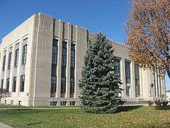 Shelby County Courthouse in Shelbyville | |
 Location in the U.S. state of Indiana | |
 Indiana's location in the U.S. | |
| Founded | 1821 |
| Named for | Isaac Shelby |
| Seat | Shelbyville |
| Largest city | Shelbyville |
| Area | |
| • Total | 412.76 sq mi (1,069 km2) |
| • Land | 411.15 sq mi (1,065 km2) |
| • Water | 1.61 sq mi (4 km2), 0.39% |
| Population | |
| • (2010) | 44,436 |
| • Density | 108/sq mi (41.58/km²) |
| Congressional district | 6th |
| Time zone | Eastern: UTC-5/-4 |
| Website |
www |
| Footnotes: Indiana county number 73 | |
Shelby County is a county located in the U.S. state of Indiana. As of 2010, the population was 44,436.[1] The county seat is Shelbyville.[2]
History
Shelby County was organized in 1821. It was named for Gen. Isaac Shelby, who defeated the British at the Battle of Kings Mountain in the Revolutionary War. Shelby then became the first Governor of Kentucky. During the War of 1812, he led the army of Kentucky into Canada, and defeated the British at the decisive Battle of the Thames in 1813.
Geography
According to the 2010 census, the county has a total area of 412.76 square miles (1,069.0 km2), of which 411.15 square miles (1,064.9 km2) (or 99.61%) is land and 1.61 square miles (4.2 km2) (or 0.39%) is water.[3]
Cities and towns
Unincorporated towns
Townships
- Addison
- Brandywine
- Hanover
- Hendricks
- Jackson
- Liberty
- Marion
- Moral
- Noble
- Shelby
- Sugar Creek
- Union
- Van Buren
- Washington
Adjacent counties
- Hancock County (north)
- Rush County (east)
- Decatur County (southeast)
- Bartholomew County (south)
- Johnson County (west)
- Marion County (northwest)
Major highways
 Interstate 65
 Interstate 74
 U.S. Route 52
 Indiana State Road 9
 Indiana State Road 44
 Indiana State Road 244
 Indiana State Road 252
Climate and weather
| Shelbyville, Indiana | ||||||||||||||||||||||||||||||||||||||||||||||||||||||||||||
|---|---|---|---|---|---|---|---|---|---|---|---|---|---|---|---|---|---|---|---|---|---|---|---|---|---|---|---|---|---|---|---|---|---|---|---|---|---|---|---|---|---|---|---|---|---|---|---|---|---|---|---|---|---|---|---|---|---|---|---|---|
| Climate chart (explanation) | ||||||||||||||||||||||||||||||||||||||||||||||||||||||||||||
| ||||||||||||||||||||||||||||||||||||||||||||||||||||||||||||
| ||||||||||||||||||||||||||||||||||||||||||||||||||||||||||||
In recent years, average temperatures in Shelbyville have ranged from a low of 18 °F (−8 °C) in January to a high of 86 °F (30 °C) in July, although a record low of −25 °F (−32 °C) was recorded in January 1994 and a record high of 105 °F (41 °C) was recorded in July 1954. Average monthly precipitation ranged from 2.38 inches (60 mm) in January to 4.47 inches (114 mm) in May.[4]
Government
The county government is a constitutional body, and is granted specific powers by the Constitution of Indiana, and by the Indiana Code.
County Council: The county council is the legislative branch of the county government and controls all the spending and revenue collection in the county. Representatives are elected from county districts. The council members serve four-year terms. They are responsible for setting salaries, the annual budget, and special spending. The council also has limited authority to impose local taxes, in the form of an income and property tax that is subject to state level approval, excise taxes, and service taxes.[5][6]
Board of Commissioners: The executive body of the county is made of a board of commissioners. The commissioners are elected county-wide, in staggered terms, and each serves a four-year term. One of the commissioners, typically the most senior, serves as president. The commissioners are charged with executing the acts legislated by the council, collecting revenue, and managing the day-to-day functions of the county government.[5][6]
Court: The county maintains a small claims court that can handle some civil cases. The judge on the court is elected to a term of four years and must be a member of the Indiana Bar Association. The judge is assisted by a constable who is also elected to a four-year term. In some cases, court decisions can be appealed to the state level circuit court.[6]
County Officials: The county has several other elected offices, including sheriff, coroner, auditor, treasurer, recorder, surveyor, and circuit court clerk. Each of these elected officers serves a term of four years and oversee different parts of the county government. Members elected to county government positions are required to declare party affiliations and to be residents of the county.[6]
Current elected officials
- County Commissioners[7]
- Donald Parker
- Kevin Nigh
- Chris Ross
- County Council
- Terry Smith
- Bob Carmony
- Tom Debaun
- Brent Fuchs
- Linda Sanders
- Tami Grubbs
- Margaret Brunk
Demographics
| Historical population | |||
|---|---|---|---|
| Census | Pop. | %± | |
| 1830 | 6,295 | — | |
| 1840 | 12,005 | 90.7% | |
| 1850 | 15,502 | 29.1% | |
| 1860 | 19,569 | 26.2% | |
| 1870 | 21,892 | 11.9% | |
| 1880 | 25,257 | 15.4% | |
| 1890 | 25,454 | 0.8% | |
| 1900 | 26,491 | 4.1% | |
| 1910 | 26,802 | 1.2% | |
| 1920 | 25,982 | −3.1% | |
| 1930 | 26,552 | 2.2% | |
| 1940 | 25,953 | −2.3% | |
| 1950 | 28,026 | 8.0% | |
| 1960 | 34,093 | 21.6% | |
| 1970 | 37,797 | 10.9% | |
| 1980 | 39,887 | 5.5% | |
| 1990 | 40,307 | 1.1% | |
| 2000 | 43,445 | 7.8% | |
| 2010 | 44,436 | 2.3% | |
| Est. 2015 | 44,478 | [8] | 0.1% |
| U.S. Decennial Census[9] 1790-1960[10] 1900-1990[11] 1990-2000[12] 2010-2013[1] | |||
As of the 2010 United States Census, there were 44,436 people, 17,302 households, and 12,221 families residing in the county.[13] The population density was 108.1 inhabitants per square mile (41.7/km2). There were 19,080 housing units at an average density of 46.4 per square mile (17.9/km2).[3] The racial makeup of the county was 95.4% white, 1.0% black or African American, 0.5% Asian, 0.2% American Indian, 1.6% from other races, and 1.2% from two or more races. Those of Hispanic or Latino origin made up 3.7% of the population.[13] In terms of ancestry, 28.5% were German, 13.1% were American, 12.2% were Irish, and 9.0% were English.[14]
Of the 17,302 households, 33.8% had children under the age of 18 living with them, 54.4% were married couples living together, 10.5% had a female householder with no husband present, 29.4% were non-families, and 24.5% of all households were made up of individuals. The average household size was 2.53 and the average family size was 2.98. The median age was 39.9 years.[13]
The median income for a household in the county was $47,697 and the median income for a family was $60,824. Males had a median income of $46,325 versus $32,416 for females. The per capita income for the county was $26,398. About 7.4% of families and 10.0% of the population were below the poverty line, including 13.7% of those under age 18 and 10.5% of those age 65 or over.[15]
Born in Shelby County
- Isaac Colton Ash, Los Angeles, California, City Council member, 1925–27
- George W. Clarke, governor of Iowa, 1913–1917
See also
References
- 1 2 "Shelby County QuickFacts". United States Census Bureau. Retrieved 2011-09-25.
- ↑ "Find a County". National Association of Counties. Retrieved 2011-06-07.
- 1 2 "Population, Housing Units, Area, and Density: 2010 - County". United States Census Bureau. Retrieved 2015-07-10.
- 1 2 "Monthly Averages for Shelbyville, Indiana". The Weather Channel. Retrieved 2011-01-27.
- 1 2 Indiana Code. "Title 36, Article 2, Section 3". IN.gov. Retrieved 2008-09-16.
- 1 2 3 4 Indiana Code. "Title 2, Article 10, Section 2" (PDF). IN.gov. Retrieved 2008-09-16.
- ↑ "Shelby County Chamber of Commerce". Retrieved 2008-01-04.
- ↑ "County Totals Dataset: Population, Population Change and Estimated Components of Population Change: April 1, 2010 to July 1, 2015". Retrieved July 2, 2016.
- ↑ "U.S. Decennial Census". United States Census Bureau. Retrieved July 10, 2014.
- ↑ "Historical Census Browser". University of Virginia Library. Retrieved July 10, 2014.
- ↑ "Population of Counties by Decennial Census: 1900 to 1990". United States Census Bureau. Retrieved July 10, 2014.
- ↑ "Census 2000 PHC-T-4. Ranking Tables for Counties: 1990 and 2000" (PDF). United States Census Bureau. Retrieved July 10, 2014.
- 1 2 3 "DP-1 Profile of General Population and Housing Characteristics: 2010 Demographic Profile Data". United States Census Bureau. Retrieved 2015-07-10.
- ↑ "DP02 SELECTED SOCIAL CHARACTERISTICS IN THE UNITED STATES – 2006-2010 American Community Survey 5-Year Estimates". United States Census Bureau. Retrieved 2015-07-10.
- ↑ "DP03 SELECTED ECONOMIC CHARACTERISTICS – 2006-2010 American Community Survey 5-Year Estimates". United States Census Bureau. Retrieved 2015-07-10.
- Young, Julie (2010). A brief history of Shelby County, Indiana. Charleston, SC: History Press. ISBN 978-1-59629-846-0.
 |
Marion County | Hancock County | | |
| Johnson County | |
Rush County | ||
| ||||
| | ||||
| Bartholomew County | Decatur County |
Municipalities and communities of Shelby County, Indiana, United States | ||
|---|---|---|
| City | ||
| Towns | ||
| Townships | ||
| CDP | ||
| Other unincorporated communities |
| |
| Footnotes | ‡This populated place also has portions in an adjacent county or counties | |

Coordinates: 39°31′N 85°47′W / 39.52°N 85.79°W