Tipton County, Indiana
| Tipton County, Indiana | |
|---|---|
 | |
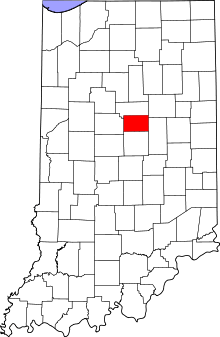 Location in the U.S. state of Indiana | |
 Indiana's location in the U.S. | |
| Founded | 1844 |
| Named for | John Tipton |
| Seat | Tipton |
| Largest city | Tipton |
| Area | |
| • Total | 260.57 sq mi (675 km2) |
| • Land | 260.54 sq mi (675 km2) |
| • Water | 0.03 sq mi (0 km2), 0.01% |
| Population | |
| • (2010) | 15,936 |
| • Density | 61/sq mi (23.63/km²) |
| Congressional district | 5th |
| Time zone | Eastern: UTC-5/-4 |
| Website |
www |
| Footnotes: Indiana county number 80 | |
Tipton County is located in central Indiana, north of the state capital of Indianapolis. According to the 2010 census, the population was 15,936, a decrease of 3.9% from the 2000 population of 16,577.[1] The county seat is Tipton.[2] The county has four incorporated towns with a total population of about 7,000,[3] as well as many small unincorporated communities. It is divided into six townships which provide local services.[4][5] Three Indiana state roads and one U.S. Route cross the county,[6] as do two railroad lines.[7]
Before the arrival of non-indigenous settlers in the early 19th century, the area was inhabited by several Native American tribes. The county was officially established in 1844 and was one of the last Indiana counties to be settled.
History
Prior to the arrival of non-indigenous settlers in the 1830s, the area now known as Tipton County was inhabited by the Miami and Delaware tribes.[8] Tipton County was formed in 1844. It was named for John Tipton, a soldier of the Battle of Tippecanoe in 1811. Tipton served as United States Senator for Indiana from 1831 until shortly before his death in 1839.[9]
The first murder to take place in the county was in October 1851. Harvey Moon stabbed Andrew Hornbeck, with a knife, to death. Moon went to Indianapolis for his trial because a jury was unable to be successfully secured in Tipton County. He was sentenced to five years in prison. He escaped prison and was never seen again.[10]
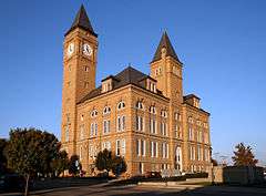
Courthouse
The first Tipton County Courthouse was a two-story frame building. It was planned in early 1845 and was completed by the end of the year at a cost of about $1200.[n 1] It was expanded the following year. By 1858 a new courthouse was needed, and the brick building was completed by 1859 at a cost of approximately $15,000.[n 2][12]
The present courthouse was designed by Adolph Sherrer. He had taken over the Indiana Statehouse project when architect Edwin May died in 1880; five years after the completion of that project in 1888, Scherrer began work on the Tipton building, which was built of sandstone in a Romanesque style with a clock tower that rises 206 feet above the ground, including the flagstaff on top. It was built by Pierce and Morgan of Indianapolis during 1893 and 1894 at a cost of $170,988.[n 3] It is one of several Romanesque courthouses dating from the 1890s that are still in use.[13]
Geography

Tipton County lies in the central part of the state. One county, Hamilton, separates it from Indianapolis and Marion County to the south. To the north lies Howard County; to the west, Clinton County; and to the east, Madison County. A short portion of the eastern border, less than 2 miles (3.2 km) long, is shared with Grant County to the northeast.
Most of the county consists of level till plain with elevations from 850 feet (260 m) to 900 feet (270 m) above sea level.[14] Prior to settlement by non-indigenous people, it was mostly covered with dense forests consisting of oak, beech, maple, walnut, hickory, sycamore and tulip trees. The southern part of the county has better natural drainage, and this area was first cleared for agriculture. Much of the rest of the county tended to be swampy due to the level ground and lack of sufficient natural waterways, so drainage channels had to be dug to make the land suitable for farming.[15]
According to the 2010 census, the county has a total area of 260.57 square miles (674.9 km2), of which 260.54 square miles (674.8 km2) (or 99.99%) is land and 0.03 square miles (0.078 km2) (or 0.01%) is water.[16]
The county is divided into six townships: Cicero, Jefferson, Liberty, Madison, Prairie and Wildcat.[4]
There are four incorporated settlements in the county. The largest is Tipton. Located near the center of the county, it is the county seat; its population in 2010 was 5,106.[17]Kempton is located near the western border in Jefferson Township and has a population of 335.[18] The town of Sharpsville is located near the northern border, in Liberty Township; its population is 607.[19] Wildcat Township contains Windfall City, which has a population of 708.[20] The city of Elwood lies in Madison County to the east and extends slightly over the border; as of the 2000 census, seven Elwood residents lived in Tipton County.[3] The county also contains several unincorporated communities.[21]
- East Union
- Ekin
- Goldsmith
- Groomsville
- Hobbs
- Jackson
- Nevada
- New Lancaster
- Normanda
- Tetersburg
- Curtisville
- West Elwood
Climate and weather
| Tipton, Indiana | ||||||||||||||||||||||||||||||||||||||||||||||||||||||||||||
|---|---|---|---|---|---|---|---|---|---|---|---|---|---|---|---|---|---|---|---|---|---|---|---|---|---|---|---|---|---|---|---|---|---|---|---|---|---|---|---|---|---|---|---|---|---|---|---|---|---|---|---|---|---|---|---|---|---|---|---|---|
| Climate chart (explanation) | ||||||||||||||||||||||||||||||||||||||||||||||||||||||||||||
| ||||||||||||||||||||||||||||||||||||||||||||||||||||||||||||
| ||||||||||||||||||||||||||||||||||||||||||||||||||||||||||||
Tipton County is in the humid continental climate region of the United States along with most of Indiana. Its Köppen climate classification is Dfa,[23] meaning that it is cold, has no dry season, and has a hot summer.[24] In recent years, average temperatures in Tipton have ranged from a low of 15 °F (−9 °C) in January to a high of 83 °F (28 °C) in July, although a record low of −25 °F (−32 °C) was recorded in January 1994 and a record high of 98 °F (37 °C) was recorded in July 1999. Average monthly precipitation ranged from 1.67 inches (42 mm) in February to 4.24 inches (108 mm) in June.[22] From 1950 through 2009, 13 tornadoes were reported in Tipton County, resulting in two deaths and several injuries; the total estimated property damage was over $3 million.[25]
Demographics
| Historical population | |||
|---|---|---|---|
| Census | Pop. | %± | |
| 1850 | 3,532 | — | |
| 1860 | 8,170 | 131.3% | |
| 1870 | 11,953 | 46.3% | |
| 1880 | 14,407 | 20.5% | |
| 1890 | 18,157 | 26.0% | |
| 1900 | 19,116 | 5.3% | |
| 1910 | 17,459 | −8.7% | |
| 1920 | 16,152 | −7.5% | |
| 1930 | 15,208 | −5.8% | |
| 1940 | 15,135 | −0.5% | |
| 1950 | 15,566 | 2.8% | |
| 1960 | 15,856 | 1.9% | |
| 1970 | 16,650 | 5.0% | |
| 1980 | 16,819 | 1.0% | |
| 1990 | 16,119 | −4.2% | |
| 2000 | 16,577 | 2.8% | |
| 2010 | 15,936 | −3.9% | |
| Est. 2015 | 15,267 | [26] | −4.2% |
| U.S. Decennial Census[27] 1790-1960[28] 1900-1990[29] 1990-2000[30] 2010-2013[1] | |||
As of the 2010 United States Census, there were 15,936 people, 6,376 households, and 4,517 families residing in the county.[31] The population density was 61.2 inhabitants per square mile (23.6/km2). There were 6,998 housing units at an average density of 26.9 per square mile (10.4/km2).[16] The racial makeup of the county was 97.6% white, 0.4% Asian, 0.2% black or African American, 0.1% American Indian, 0.7% from other races, and 1.0% from two or more races. Those of Hispanic or Latino origin made up 2.2% of the population.[31] In terms of ancestry, 28.5% were German, 14.5% were American, 12.3% were English, and 9.6% were Irish.[32]
Of the 6,376 households, 30.7% had children under the age of 18 living with them, 57.1% were married couples living together, 9.6% had a female householder with no husband present, 29.2% were non-families, and 25.4% of all households were made up of individuals. The average household size was 2.47 and the average family size was 2.93. The median age was 42.6 years.[31]
The median income for a household in the county was $47,697 and the median income for a family was $61,115. Males had a median income of $42,763 versus $29,832 for females. The per capita income for the county was $23,499. About 3.3% of families and 6.5% of the population were below the poverty line, including 7.7% of those under age 18 and 5.5% of those age 65 or over.[33]
Economy
Tipton County's economy is supported by a labor force of approximately 7,699 workers with an unemployment rate in December 2015 of 3.8%.[34]
Agriculture
Historically, Tipton County's economy has been agriculturally based. In 1914, the county had 2,067 working farms and 166,400 acres of farm land.[35] Upon early settlement, corn, wheat, oats, rye, flax, and potatoes were the primary early crops grown in the county. Hay was grown in the prairie areas.[36] Fruit was profitable in the county up until 1880, but blight lessened yield and fruit growing almost halted.[37]
The Tipton County Agricultural Society was organized in August 1855. They held the first county fair that October. It was described as a "failure," and was followed by another unsuccessful fair the following year. That organization was dissolved, another formed, only to be dissolved again. A third organization, the Tipton County Joint-Stock Agricultural Society formed in 1874.[38] That organization eventually failed and finally, the Tipton County Fair Company was formed in 1879.[39] By the early 20th century, corn and wheat were primary crops.[40]
Banking
The first bank founded in the county was Vickrey Bank in Tipton in the mid-1800s. The bank eventually became Union Bank and finally Farmers Loan and Trust Company. In 1876, the Tipton County Bank was founded. It merged with First National Bank in 1902. Other historical banks in the county included Citizens National Bank (1898), Farmers Loan and Trust Company (1906), People's State Bank (1892), Sharpsville Bank (1902) and the State Bank of Kempton (1900). None of these banks exist today. Farmers' State Bank was formed in 1914 and remains in business today as First Farmers Bank & Trust.[41]
Government
The county government is a constitutional body granted specific powers by the Constitution of Indiana and the Indiana Code. The county council is the legislative branch of the county government and controls all spending and revenue collection. Representatives are elected from county districts. The council members serve four-year terms and are responsible for setting salaries, the annual budget and special spending. The council also has limited authority to impose local taxes, in the form of an income and property tax that is subject to state level approval, excise taxes and service taxes.[42][43]
The executive body of the county is made of a board of commissioners. The commissioners are elected county-wide, in staggered terms, and each serves a four-year term. One of the commissioners, typically the most senior, serves as president. The commissioners are charged with executing the acts legislated by the council, collecting revenue and managing day-to-day functions of the county government.[42][43]
The county maintains a small claims court that can handle some civil cases. The judge on the court is elected to a term of four years and must be a member of the Indiana Bar Association. The judge is assisted by a constable who is elected to a four-year term. In some cases, court decisions can be appealed to the state level circuit court.[43]
The county has several other elected offices, including sheriff, coroner, auditor, treasurer, recorder, surveyor and circuit court clerk. Each of these elected officers serves a term of four years and oversees a different part of county government. Members elected to county government positions are required to declare party affiliations and be residents of the county.[43]
Each of the townships has a trustee who administers rural fire protection and ambulance service, provides poor relief and manages cemetery care, among other duties.[5] The trustee is assisted in these duties by a three-member township board. The trustees and board members are elected to four-year terms.[44]
Tipton County is part of Indiana's 5th congressional district; Indiana Senate districts 20 and 21;[45] and Indiana House of Representatives districts 32 and 35.[46]
Education
Early history
In 1889, county schools had a total enrollment of 6,225. There were a total of 84 schools across the county. The majority of teachers were male, totaling 81 male and 19 female teachers. They were paid approximately $2 a day for their work. By 1914, the school enrollment totaled 3,701 students, with 65 schools across the county. There were five high schools located across the township in Sharpsville, Tipton, Kempton, Goldsmith and Windfall. There were 218 teachers. They were paid $3.19 a day.[47]
Today
Tipton County has six schools, managed by three school corporations.[48] The Tipton Community School Corporation includes an elementary school, a middle school, and a high school, all located in Tipton; these schools served a total of 1,821 students during the 2009–2010 school year.[49] In the north part of the county, Tri-Central Community Schools (formerly Northern Community Schools) includes an elementary school and Tri-Central Middle/High School, both located in Sharpsville; these schools served a total of 970 students during the same school year.[50] Saint John the Baptist School was located in Tipton and was part of the Diocese of Lafayette Catholic Schools; it was an elementary school and served 82 students during the 2009–2010 school year.,[51] but it closed in 2014 due to declining enrollment.
Media
The first newspaper founded in the county was the Tipton County Democrat in 1855. The paper changed its name, in 1857, to Western Dominion. The paper was sold in 1858 to G.W. Fisher who changed the paper's name to the Tipton County Times.[52] The paper's name was changed again in 1862 to the Democratic Union, and then back to the Tipton County Times in 1869. The Tipton Republican was founded in the county in 1860.[53] The newspaper closed when the editor in chief joined the army. Additional newspapers founded during this period included the Enterprise (1872), the Tipton Advance, (1874), a second Tipton Republican (1876), The Advocate (1878), the Windfall Herald (1891), the Kempton Courier (1907), the Saturday Express (1882), and the Windfall News (1876). None of these papers exist today.[54]
The Tipton County Tribune was founded in 1895. The paper continues to be published today.[55]
Infrastructure
Transportation
No interstate highways run through Tipton County. U.S. Route 31 runs through the western part of the county, entering from Howard County and Kokomo in the north and continuing to Hamilton County and Indianapolis in the south.[56] State Road 19 and State Road 28 intersect in the county seat of Tipton.[57][58] State Road 213 runs from north to south in the eastern part of the county, passing through the town of Windfall.[59]
Though they do not run through the county, three other state roads touch its southeastern corner. State Road 13 and State Road 37 share the same route here while approaching Elwood.[60][61] The point where they touch the corner of Tipton County is also the western terminus of State Road 128.[62]
Two Norfolk Southern Railway routes run through the county. One line connects Muncie in the east with Frankfort in the west. The other connects Logansport and Kokomo in the north with Indianapolis in the south. The two lines intersect in Tipton.[7]
Notable people
Charles Benjamin "Babe" Adams was born in Tipton in 1882. He became a baseball pitcher, and aside from a single game played for the Saint Louis Cardinals in 1906, he played his entire Major League career with the Pittsburgh Pirates, and was known for his location control. His last Major League game was in 1926. He died in 1968 at age 86.[63]
John Bunch was born in Tipton in 1921 and became a jazz pianist. While still in his early teens, he was playing in local clubs, and went on to play with the bands of Woody Herman, Benny Goodman and Maynard Ferguson. He composed many original works, and continued playing in various roles through early 2010. He died in Manhattan soon after his last engagement; he was 88 years old.[64]
See also
Notes
References
- 1 2 "Tipton County QuickFacts". United States Census Bureau. Retrieved 2011-09-25.
- ↑ "Find a County – Tipton County, IN". National Association of Counties. Retrieved 2011-11-15.
- 1 2 "Tipton County, Indiana – County Subdivision and Place. GCT-PH1. Population, Housing Units, Area, and Density: 2000". United States Census Bureau. Retrieved 2011-02-09.
- 1 2 "Tipton". Indiana Township Association. Retrieved 2011-11-15.
- 1 2 "Duties". United Township Association of Indiana. Retrieved 2011-01-06.
- ↑ "Indiana Transportation Map 2009–2010" (PDF). Indiana Department of Transportation. 2009. Retrieved 2010-12-16.
- 1 2 "State of Indiana 2011 Rail System Map" (PDF). Indiana Department of Transportation. 2011. Retrieved 2011-06-19.
- ↑ Goodspeed 1883, pp. 1–2.
- ↑ Goodrich, De Witt Clinton; Tuttle, Charles Richard (1875). An Illustrated History of the State of Indiana. Indianapolis: R. S. Peale and Company. p. 574.
- ↑ Pershing, p. 248
- 1 2 3 Williamson, Samuel H. (April 2010). Seven Ways to Compute the Relative Value of a U.S. Dollar Amount, 1774 to present. MeasuringWorth. Calculations made using Nominal GDP Per Capita, a measure of capital intensivity, using "the 'average' per-person output of the economy in the prices of the current year." This is a measure of the amount of capital and volume of labor required to reproduce the work over varying production methods, but assuming that money represents a proportion of the economy.
- ↑ Goodspeed 1883, pp. 18–20.
- ↑ Counts, Will; Jon Dilts (1991). The 92 Magnificent Indiana Courthouses. Bloomington, Indiana: Indiana University Press. pp. 166–7. ISBN 978-0-253-33638-5.
- ↑ Hurst 1914, p. 1–2.
- ↑ Hurst 1914, p. 10.
- 1 2 "Population, Housing Units, Area, and Density: 2010 - County". United States Census Bureau. Retrieved 2015-07-10.
- ↑ "QuickFacts Tipton city, IndianaWhat's". United States Census Bureau. Retrieved 2016-02-22.
- ↑ "2010 Census Population of Kempton, Indiana". United States Census Bureau. Retrieved 2016-02-22.
- ↑ "Sharpsville, Indiana Population". United States Census Bureau. Retrieved 2016-02-22.
- ↑ "Windfall City Census Population". United States Census Bureau. Retrieved 2016-02-22.
- ↑ United States Geological Survey. "Geographic Names Information System: Populated places in Tipton County, Indiana". Retrieved 2011-11-15.
- 1 2 "Monthly Averages for Tipton, Indiana". The Weather Channel. Retrieved 2011-01-27.
- ↑ "Köppen Climate Classification for the Conterminous United States". Idaho State Climate Services. Retrieved 2011-01-23.
- ↑ Peel, M. C.; Finlayson, B. L.; McMahon, T. A. (2007). "Updated world map of the Köppen-Geiger climate classification" (PDF). Copernicus Publications. p. 1636. Retrieved 2011-01-23.
- ↑ "Tipton County Tornadoes, 1950–2009". National Weather Service. Retrieved 2011-11-15.
- ↑ "County Totals Dataset: Population, Population Change and Estimated Components of Population Change: April 1, 2010 to July 1, 2015". Retrieved July 2, 2016.
- ↑ "U.S. Decennial Census". United States Census Bureau. Retrieved July 10, 2014.
- ↑ "Historical Census Browser". University of Virginia Library. Retrieved July 10, 2014.
- ↑ "Population of Counties by Decennial Census: 1900 to 1990". United States Census Bureau. Retrieved July 10, 2014.
- ↑ "Census 2000 PHC-T-4. Ranking Tables for Counties: 1990 and 2000" (PDF). United States Census Bureau. Retrieved July 10, 2014.
- 1 2 3 "DP-1 Profile of General Population and Housing Characteristics: 2010 Demographic Profile Data". United States Census Bureau. Retrieved 2015-07-10.
- ↑ "DP02 SELECTED SOCIAL CHARACTERISTICS IN THE UNITED STATES – 2006-2010 American Community Survey 5-Year Estimates". United States Census Bureau. Retrieved 2015-07-10.
- ↑ "DP03 SELECTED ECONOMIC CHARACTERISTICS – 2006-2010 American Community Survey 5-Year Estimates". United States Census Bureau. Retrieved 2015-07-10.
- ↑ STATS Indiana. "InDepth Profile: Tipton County, Indiana". Indiana Business Research Center. Retrieved 2016-02-22.
- ↑ Pershing, p. 214
- ↑ Pershing, p. 215
- ↑ Pershing, p. 219
- ↑ Pershing, p. 221
- ↑ Pershing, p. 222
- ↑ Pershing, p. 216
- ↑ Pershing, p. 237
- 1 2 Indiana Code. "Title 36, Article 2, Section 3". Government of Indiana. Retrieved 2008-09-16.
- 1 2 3 4 Indiana Code. "Title 2, Article 10, Section 2" (PDF). Government of Indiana. Retrieved 2008-09-16.
- ↑ "Government". United Township Association of Indiana. Retrieved 2011-01-06.
- ↑ "Indiana Senate Districts". State of Indiana. Retrieved 2011-07-14.
- ↑ "Indiana House Districts". State of Indiana. Retrieved 2011-07-14.
- ↑ Pershing, p. 195
- ↑ "Tipton County School Corporations". Indiana Department of Education. Retrieved 2011-11-16.
- ↑ "Tipton Community School Corp - Overview". Indiana Department of Education. Retrieved 2011-11-16.
- ↑ "Tri-Central Community Schools - Overview". Indiana Department of Education. Retrieved 2011-11-16.
- ↑ "Saint John the Baptist School - Overview". Indiana Department of Education. Retrieved 2011-11-16.
- ↑ Pershing, p. 223
- ↑ Pershing, p. 224
- ↑ Pershing, p. 226
- ↑ Pershing, p. 228
- ↑ "U.S. Route 31". Highway Explorer. Retrieved 2011-11-15.
- ↑ "State Road 19". Highway Explorer. Retrieved 2011-11-15.
- ↑ "State Road 28". Highway Explorer. Retrieved 2011-11-15.
- ↑ "State Road 213". Highway Explorer. Retrieved 2011-11-15.
- ↑ "State Road 13". Highway Explorer. Retrieved 2011-11-15.
- ↑ "State Road 37". Highway Explorer. Retrieved 2011-11-15.
- ↑ "State Road 128". Highway Explorer. Retrieved 2011-11-15.
- ↑ "Babe Adams". Retrieved 2011-11-17.
- ↑ "John Bunch". Retrieved 2011-11-17.
Bibliography
- Goodspeed, Weston A. (1883). "Part III: History of Tipton County". In Blanchard, Charles. Counties of Howard and Tipton, Indiana. Chicago: F. A. Battey and Company.
- Hurst, Lewis A.; Grimes, E. J. (1914). Soil Survey of Tipton County, Indiana (PDF). United States Department of Agriculture (Report). Washington: U.S. Government Printing Office. Retrieved 2011-11-16.
- Pershing, Marvin W. "History of Tipton County, Indiana: Her People, Industries and Institutions". Indianapolis: B.F. Bowen (1914).
External links
| Wikimedia Commons has media related to Tipton County, Indiana. |
- The Official website for Tipton County Indiana
- Tipton County information & community website
- Tipton County Chamber of Commerce
- The Dunham House Located in Kempton, Tipton County
 |
Howard County | Grant County | | |
| Clinton County | |
Madison County | ||
| ||||
| | ||||
| Hamilton County |
Municipalities and communities of Tipton County, Indiana, United States | ||
|---|---|---|
| Cities | ||
| Towns | ||
| Townships | ||
| Unincorporated communities | ||
| Ghost town | ||
| Footnotes | ‡This populated place also has portions in an adjacent county or counties | |

Coordinates: 40°19′N 86°03′W / 40.31°N 86.05°W