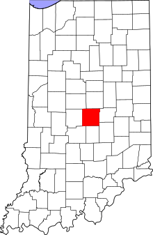
Marion County, Indiana
| Marion County, Indiana | |
|---|---|
 | |
 Location in the U.S. state of Indiana | |
 Indiana's location in the U.S. | |
| Founded | April 01, 1822 |
| Named for | Francis Marion |
| Seat | Indianapolis |
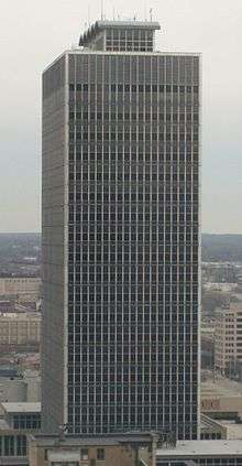
| Largest city | Indianapolis |
| Area | |
| • Total | 403.01 sq mi (1,044 km2) |
| • Land | 396.30 sq mi (1,026 km2) |
| • Water | 6.71 sq mi (17 km2), 1.66% |
| Population (est.) | |
| • (2015) | 939,020 |
| • Density | 2,357/sq mi (880.5/km²) |
| Congressional districts | 5th, 7th |
| Time zone | Eastern: UTC-5/-4 |
| Website |
www |
|
Footnotes:
| |
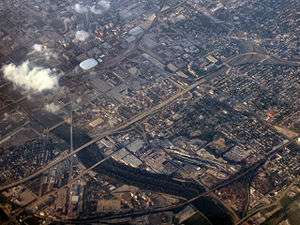
Marion County is a county located in the U.S. state of Indiana. Census 2010 recorded a population of 903,393,[1] making it the largest county in the state and 55th most populated county in the country, greater than the population of six states. The county seat is Indianapolis, the state capital and largest city.[2] Marion County is consolidated with Indianapolis through an arrangement known as Unigov.
Marion County is included in the Indianapolis-Carmel-Anderson, IN Metropolitan Statistical Area.
Geography
According to the 2010 census, the county has a total area of 403.01 square miles (1,043.8 km2), of which 396.30 square miles (1,026.4 km2) (or 98.34%) is land and 6.71 square miles (17.4 km2) (or 1.66%) is water.[3]
The White River flows through the county where it is joined by Eagle Creek and Fall Creek, both of which have dams in the county forming Eagle Creek Reservoir and Geist Reservoir, respectively.
Marion County contains two Indiana State Parks, Fort Harrison State Park and White River State Park, as well as numerous municipal parks.
Adjacent counties
- Hamilton County (north)
- Hancock County (east)
- Shelby County (southeast)
- Johnson County (south)
- Morgan County (southwest)
- Hendricks County (west)
- Boone County (northwest)
Major highways
|
Interstate Highways |
US Highways |
Indiana Highways |
* I-69 currently ends in Indianapolis at the I-465 interchange in the northeast section of the county. The extension connecting Indianapolis and Evansville is expected to be completed around 2018.
Airports
- KIND - Indianapolis International Airport
- KEYE - Eagle Creek Airpark
- Post-Air Airport
History
Marion County was created on April 1, 1822, from part of the so-called "New Purchase" lands that had been obtained by the Treaty of St. Mary's; the Lenape had previously occupied the area.[4] It is named for Francis Marion, a Brigadier General from South Carolina in the American Revolutionary War.[5][6]
The state capital was moved to Indianapolis in Marion County from Corydon on January 10, 1825. This began a period of rapid growth in population.[6]
Climate and weather
| Indianapolis, Indiana | ||||||||||||||||||||||||||||||||||||||||||||||||||||||||||||
|---|---|---|---|---|---|---|---|---|---|---|---|---|---|---|---|---|---|---|---|---|---|---|---|---|---|---|---|---|---|---|---|---|---|---|---|---|---|---|---|---|---|---|---|---|---|---|---|---|---|---|---|---|---|---|---|---|---|---|---|---|
| Climate chart (explanation) | ||||||||||||||||||||||||||||||||||||||||||||||||||||||||||||
| ||||||||||||||||||||||||||||||||||||||||||||||||||||||||||||
| ||||||||||||||||||||||||||||||||||||||||||||||||||||||||||||
In recent years, average temperatures in Indianapolis have ranged from a low of 18 °F (−8 °C) in January to a high of 84 °F (29 °C) in July, although a record low of −22 °F (−30 °C) was recorded in January 1985 and a record high of 104 °F (40 °C) was recorded in June 1988. Average monthly precipitation ranged from 2.05 inches (52 mm) in January to 4.78 inches (121 mm) in July.[7]
Demographics
| Historical population | |||
|---|---|---|---|
| Census | Pop. | %± | |
| 1830 | 7,192 | — | |
| 1840 | 16,080 | 123.6% | |
| 1850 | 24,103 | 49.9% | |
| 1860 | 39,855 | 65.4% | |
| 1870 | 71,939 | 80.5% | |
| 1880 | 102,782 | 42.9% | |
| 1890 | 141,156 | 37.3% | |
| 1900 | 197,227 | 39.7% | |
| 1910 | 263,661 | 33.7% | |
| 1920 | 348,061 | 32.0% | |
| 1930 | 422,666 | 21.4% | |
| 1940 | 460,926 | 9.1% | |
| 1950 | 551,777 | 19.7% | |
| 1960 | 697,567 | 26.4% | |
| 1970 | 792,299 | 13.6% | |
| 1980 | 765,233 | −3.4% | |
| 1990 | 797,159 | 4.2% | |
| 2000 | 860,454 | 7.9% | |
| 2010 | 903,393 | 5.0% | |
| Est. 2015 | 939,020 | [8] | 3.9% |
| U.S. Decennial Census[9] 1790-1960[10] 1900-1990[11] 1990-2000[12] 2010-2013[1] | |||
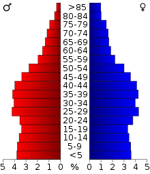
As of the 2010 United States Census, there were 903,393 people, 366,176 households, and 218,338 families residing in the county.[13] The population density was 2,279.6 inhabitants per square mile (880.2/km2). There were 417,862 housing units at an average density of 1,054.4 per square mile (407.1/km2).[3] The racial makeup of the county was 62.7% white, 26.7% black or African American, 2.0% Asian, 0.3% American Indian, 0.1% Pacific islander, 5.4% from other races, and 2.8% from two or more races. Those of Hispanic or Latino origin made up 9.3% of the population.[13] In terms of ancestry, 18.9% were German, 11.8% were Irish, 8.4% were English, 6.6% were American, and 5.2% were Subsaharan African.[14]
Of the 366,176 households, 32.3% had children under the age of 18 living with them, 36.9% were married couples living together, 17.1% had a female householder with no husband present, 40.4% were non-families, and 32.0% of all households were made up of individuals. The average household size was 2.42 and the average family size was 3.08. The median age was 33.9 years.[13]
The median income for a household in the county was $47,697 and the median income for a family was $54,142. Males had a median income of $42,215 versus $34,169 for females. The per capita income for the county was $24,498. About 13.5% of families and 17.3% of the population were below the poverty line, including 25.7% of those under age 18 and 9.0% of those age 65 or over.[15]
Cities and towns
Marion County has a consolidated city-county government, known as Unigov, in which only four municipalities retain full government autonomy (including a mayor and city council) as "excluded cities". The remaining municipalities within the county are "included towns" and exercise very limited authority, mainly in zoning and appointing their own police departments and maintaining some of their own municipal services and town identities. They retain the ability to levy taxes for these purposes. Since many of these included towns were and remain fairly wealthy and influential within the county, they can still have considerable unofficial clout. Likewise, some neighborhoods that had already been formally incorporated into Indianapolis (such as Broad Ripple) possess similar influence.
Municipalities
Excluded cities in bold.
Townships
Marion County has nine townships roughly organized into a grid-like, three-by-three pattern. This arrangement can be seen below, with the top being north.
Politics
| Year | Republican | Democratic |
|---|---|---|
| 2016 | 35.5% 130,228 | 58.0% 212,676 |
| 2012 | 37.9% 136,509 | 60.1% 216,336 |
| 2008 | 35.3% 134,313 | 63.4% 241,987 |
| 2004 | 48.7% 156,072 | 50.6% 162,249 |
| 2000 | 49.2% 137,810 | 47.9% 134,189 |
| 1996 | 47.2% 133,329 | 44.1% 124,448 |
| 1992 | 43.7% 141,369 | 37.8% 122,234 |
| 1988 | 58.6% 184,519 | 40.8% 128,627 |
| 1984 | 58.3% 184,880 | 41.0% 130,185 |
| 1980 | 53.7% 168,680 | 40.1% 126,103 |
| 1976 | 54.6% 177,767 | 44.6% 145,274 |
| 1972 | 66.5% 206,065 | 33.0% 102,166 |
| 1968 | 52.3% 162,503 | 37.2% 115,715 |
| 1964 | 48.3% 143,015 | 51.4% 152,418 |
| 1960 | 57.7% 166,202 | 42.1% 121,336 |
Marion County was up until the mid-2000s a Republican stronghold in presidential elections, giving majorities to Republicans from 1968 to 2000. The county then began trending Democratic, with John Kerry winning a majority in 2004, the first Democrat since Lyndon B. Johnson in 1964. The trend continued in 2008 and 2012 with Barack Obama showing strongly in Marion County, winning 63% and 60% of the vote respectively.
Most of Marion County is in Indiana's 7th congressional district, which is held by Democrat André Carson. Indiana's 5th congressional district, which runs along the northern edge of the county, is held by Republican Susan Brooks. The county is represented by 15 seats in the Indiana House of Representatives, 86th through 100th districts, with ten seats held by Democrats and five by Republicans. In the State Senate Marion County is divided among nine districts, which are held by two Democrats and seven Republicans. The Senate districts are numbered 28 through 36.
The Indianapolis City-County Council is the combined legislative body of Indianapolis and Marion County. The consolidated government, known as Unigov, was formally established in 1970 upon the merger of the city government with the county government. The council passes ordinances for the city and county, and also makes appointments to certain boards and commissions.
County elected officials
| Marion County Sheriff's Department | |
|---|---|
| Agency overview | |
| Legal personality | Governmental: Government agency |
| Jurisdictional structure | |
| Operations jurisdiction* | County (US) of Marion in the state of Indiana, United States |
| Legal jurisdiction | As per operations jurisdiction. |
| General nature | |
| Operational structure | |
| Agency executive | John Layton, Sheriff |
| Footnotes | |
| * Divisional agency: Division of the country, over which the agency has usual operational jurisdiction. | |
- Mayor (County Executive): Joe Hogsett (D)
- Auditor: Julie Voorhies (D)
- Clerk: Myla A. Eldrige (D)
- Coroner: Frank Lloyd, Jr. (D)
- Assessor: Joseph P. O'Connor (D)
- Prosecutor: Terry Curry (D)
- Recorder: Kate Sweeney Bell (D)
- Sheriff: John R. Layton (D)
- Surveyor: Debra S. Jenkins (D)
- Treasurer: Claudia O. Fuentes (D)
The Auditor, Assessor, and Treasurer together form the county's Board of Commissioners.
References
- 1 2 "Marion County QuickFacts". United States Census Bureau. Retrieved 2011-09-25.
- ↑ "Find a County". National Association of Counties. Retrieved 2011-06-07.
- 1 2 "Population, Housing Units, Area, and Density: 2010 - County". United States Census Bureau. Retrieved 2015-07-10.
- ↑ Divita, James J. (1994). "Demography and Ethnicity". In Bodenhamer, David J.; Barrows, Robert G. The Encyclopedia of Indianapolis. Bloomington and Indianapolis: Indiana University Press. pp. 51–52. ISBN 0-253-31222-1. Retrieved July 30, 2013.
- ↑ Baker, Ronald L.; Marvin Carmony (1995). Indiana Place Names. Bloomington: Indiana University Press. p. 98. ISBN 0-253-28340-X.
- 1 2 De Witt Clinton Goodrich & Charles Richard Tuttle (1875). An Illustrated History of the State of Indiana. Indiana: R. S. Peale & co. p. 567.
- 1 2 "Monthly Averages for Indianapolis, Indiana". The Weather Channel. Retrieved 2011-01-27.
- ↑ "County Totals Dataset: Population, Population Change and Estimated Components of Population Change: April 1, 2010 to July 1, 2015". Retrieved July 2, 2016.
- ↑ "U.S. Decennial Census". United States Census Bureau. Retrieved July 10, 2014.
- ↑ "Historical Census Browser". University of Virginia Library. Retrieved July 10, 2014.
- ↑ "Population of Counties by Decennial Census: 1900 to 1990". United States Census Bureau. Retrieved July 10, 2014.
- ↑ "Census 2000 PHC-T-4. Ranking Tables for Counties: 1990 and 2000" (PDF). United States Census Bureau. Retrieved July 10, 2014.
- 1 2 3 "DP-1 Profile of General Population and Housing Characteristics: 2010 Demographic Profile Data". United States Census Bureau. Retrieved 2015-07-10.
- ↑ "DP02 SELECTED SOCIAL CHARACTERISTICS IN THE UNITED STATES – 2006-2010 American Community Survey 5-Year Estimates". United States Census Bureau. Retrieved 2015-07-10.
- ↑ "DP03 SELECTED ECONOMIC CHARACTERISTICS – 2006-2010 American Community Survey 5-Year Estimates". United States Census Bureau. Retrieved 2015-07-10.
External links
- Indianapolis and Marion County Official Website
- Marion County InDepth Profile: STATS Indiana
- County Highlights: Marion County: Hoosiers by the Numbers
 |
Boone County | Hamilton County | | |
| Hendricks County | |
Hancock County | ||
| ||||
| | ||||
| Morgan County | Johnson County | Shelby County |
Municipalities and communities of Marion County, Indiana, United States | ||
|---|---|---|
| Cities | ||
| Town | ||
| Townships | ||
| Included towns (see Unigov) | ||
| Footnotes | ‡This populated place also has portions in an adjacent county or counties | |

Coordinates: 39°47′N 86°08′W / 39.78°N 86.14°W