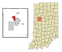
West Lafayette, Indiana
| West Lafayette, Indiana | |
|---|---|
| City | |
|
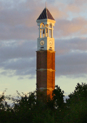
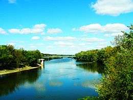
West Lafayette Public Library, with Purdue campus skyline in background | |
| Nickname(s): West Side | |
 | |
| Coordinates: 40°26′31″N 86°54′45″W / 40.44194°N 86.91250°WCoordinates: 40°26′31″N 86°54′45″W / 40.44194°N 86.91250°W | |
| Country | United States |
| State | Indiana |
| County | Tippecanoe |
| Township | Wabash |
| Incorporated | 1888 |
| Government | |
| • Mayor CAT | John Dennis (R) |
| Area[1] | |
| • City | 7.63 sq mi (19.76 km2) |
| • Land | 7.62 sq mi (19.74 km2) |
| • Water | 0.01 sq mi (0.03 km2) |
| • Metro | 904.6 sq mi (2,343 km2) |
| Elevation[2] | 614 ft (187 m) |
| Population (2010)[3] | |
| • City | 29,596 |
| • Estimate (2014[4]) | 32,109 |
| • Density | 3,884.0/sq mi (1,499.6/km2) |
| • Metro | 182,821 |
| Time zone | EST (UTC-5) |
| • Summer (DST) | EDT (UTC-4) |
| ZIP code | 47906 |
| Area code(s) | 765 |
| FIPS code | 18-82862[5] |
| GNIS feature ID | 445775 |
| Website | http://www.city.west-lafayette.in.us/ |
West Lafayette /ˌwɛst ˌlɑːfiˈɛt/ is a city in Wabash Township, Tippecanoe County, Indiana, United States,[6] about 65 miles (105 km) northwest of the state capital of Indianapolis and 103 miles (166 km) southeast of Chicago. West Lafayette is directly across the Wabash River from its sister city, Lafayette. As of the 2010 census, its population was 29,596.[7] It is the most densely populated city in Indiana and is home to Purdue University. West Lafayette is part of the Lafayette, Indiana metropolitan area.
History
Augustus Wylie laid out a town in 1836 in the Wabash River floodplain south of the present Levee. Due to regular flooding of the site, Wylie's town was never built. The present city was formed in 1888 by the merger of the adjacent suburban towns of Chauncey, Oakwood, and Kingston, located on a bluff across the Wabash River from Lafayette, Indiana.[8] The three towns had been small suburban villages which were directly adjacent to one another. Kingston was laid out in 1855 by Jesse B. Lutz. Chauncey was platted in 1860 by the Chauncey family of Philadelphia, wealthy land speculators. Chauncey and Kingston formed a municipal government in 1866 which selected the name "Chauncey".[8]
The new town of Chauncey remained a small suburban village until Purdue University opened in 1869. In 1871 Chauncey voted to be annexed by Lafayette because it was unable to provide the infrastructure (such as improved streets, waterworks, police and fire protection). Lafayette voted against annexing Chauncey because of the high cost of the many improvements that the village lacked.[9] In May 1888, the town of Chauncey voted to change its name to West Lafayette after a petition signed by 152 electors.[10] By that time, the growth of the university was fueling the growth of the little town. The address of Purdue University was given as "Lafayette, Indiana" until well into the twentieth century. West Lafayette never gained a railroad depot and lagged several years behind Lafayette in the establishment of municipal infrastructure and services. Today, West Lafayette has established itself as a separate city, with independent services and unique neighborhoods distinct from those of its sister city, Lafayette.
In November 2013, the City of West Lafayette approved an annexation that placed much of the Purdue University academic campus and residence hall system within the official boundaries of the municipality for the first time. This expansion also included a large section of the US Highway 231 corridor that was previously part of unincorporated Tippecanoe County.[11]
Alpha Tau Omega Fraternity House, Jesse Andrew House, Chauncey-Stadium Avenues Historic District, John E. and Catherine E. Christian House, Curtis-Grace House, Happy Hollow Heights Historic District, Hills and Dales Historic District, Morton School, and The Varsity are listed on the National Register of Historic Places.[12][13]

Geography
West Lafayette lies in central Tippecanoe County and overlooks the Wabash River, which borders the city on the east and south. Most of the city lies in eastern Wabash Township, though a small portion on the northeast side extends into Tippecanoe Township. Elevations range from slightly over 500 feet (150 m) near the river to more than 720 feet (220 m) in northern parts of the city near U.S. Route 52.
According to the 2010 census, West Lafayette has a total area of 7.63 square miles (19.76 km2), of which 7.62 square miles (19.74 km2) (or 99.87%) is land and 0.01 square miles (0.03 km2) (or 0.13%) is water.[1]
| Climate data for West Lafayette, Indiana | |||||||||||||
|---|---|---|---|---|---|---|---|---|---|---|---|---|---|
| Month | Jan | Feb | Mar | Apr | May | Jun | Jul | Aug | Sep | Oct | Nov | Dec | Year |
| Record high °F (°C) | 69 (21) |
73 (23) |
86 (30) |
89 (32) |
94 (34) |
105 (41) |
105 (41) |
100 (38) |
98 (37) |
92 (33) |
78 (26) |
73 (23) |
105 (41) |
| Average high °F (°C) | 34 (1) |
39 (4) |
50 (10) |
63 (17) |
73 (23) |
83 (28) |
85 (29) |
84 (29) |
78 (26) |
65 (18) |
51 (11) |
38 (3) |
61.9 (16.6) |
| Average low °F (°C) | 19 (−7) |
23 (−5) |
31 (−1) |
41 (5) |
51 (11) |
61 (16) |
64 (18) |
63 (17) |
55 (13) |
44 (7) |
34 (1) |
23 (−5) |
42.4 (5.8) |
| Record low °F (°C) | −23 (−31) |
−20 (−29) |
−3 (−19) |
7 (−14) |
25 (−4) |
35 (2) |
43 (6) |
37 (3) |
29 (−2) |
19 (−7) |
6 (−14) |
−16 (−27) |
−23 (−31) |
| Average precipitation inches (mm) | 1.86 (47.2) |
1.84 (46.7) |
2.67 (67.8) |
3.54 (89.9) |
4.19 (106.4) |
4.10 (104.1) |
3.97 (100.8) |
3.46 (87.9) |
2.66 (67.6) |
2.89 (73.4) |
2.97 (75.4) |
2.51 (63.8) |
36.66 (931.2) |
| Average snowfall inches (cm) | 6.5 (16.5) |
4.8 (12.2) |
2.9 (7.4) |
0.7 (1.8) |
0 (0) |
0 (0) |
0 (0) |
0 (0) |
0 (0) |
0.3 (0.8) |
0.8 (2) |
5.2 (13.2) |
21.2 (53.8) |
| Average precipitation days (≥ 0.01 in) | 9.6 | 7.7 | 10.2 | 10.9 | 10.6 | 10.4 | 8.9 | 8.4 | 7.6 | 8.3 | 9.8 | 10.1 | 112.5 |
| Average snowy days (≥ 0.1 in) | 5.3 | 3.3 | 1.7 | 0.3 | 0 | 0 | 0 | 0 | 0 | 0.1 | 0.9 | 3.5 | 15.1 |
| Source #1: The Weather Channel (January record high)[14] | |||||||||||||
| Source #2: NOAA: Lafayette[15] | |||||||||||||
Demographics
| Historical population | |||
|---|---|---|---|
| Census | Pop. | %± | |
| 1880 | 717 | — | |
| 1890 | 1,242 | 73.2% | |
| 1900 | 2,302 | 85.3% | |
| 1910 | 3,867 | 68.0% | |
| 1920 | 3,830 | −1.0% | |
| 1930 | 5,095 | 33.0% | |
| 1940 | 6,270 | 23.1% | |
| 1950 | 11,873 | 89.4% | |
| 1960 | 12,680 | 6.8% | |
| 1970 | 19,157 | 51.1% | |
| 1980 | 21,247 | 10.9% | |
| 1990 | 25,907 | 21.9% | |
| 2000 | 28,778 | 11.1% | |
| 2010 | 42,010 | 46.0% | |
| Est. 2015 | 45,550 | [16] | 8.4% |
| Source: US Census Bureau | |||
2010 census
As of the census[3] of 2010, there were 29,596 people, 11,945 households, and 4,072 families residing in the city. The population density was 3,884.0 inhabitants per square mile (1,499.6/km2). There were 12,591 housing units at an average density of 1,652.4 per square mile (638.0/km2). The racial makeup of the city was 70.6% White, 4.4% African American, 0.1% Native American, 17.3% Asian, 0.9% from other races, and 2.1% from two or more races. Hispanic or Latino of any race were 4.6% of the population.
There were 11,945 households of which 16.0% had children under the age of 18 living with them, 27.2% were married couples living together, 4.4% had a female householder with no husband present, 2.5% had a male householder with no wife present, and 65.9% were non-families. 34.2% of all households were made up of individuals and 7.9% had someone living alone who was 65 years of age or older. The average household size was 2.22 and the average family size was 2.92.
The median age in the city was 22.8 years. 11.8% of residents were under the age of 18; 49.4% were between the ages of 18 and 24; 18.4% were from 25 to 44; 11.7% were from 45 to 64; and 8.7% were 65 years of age or older. The gender makeup of the city was 54.2% male and 45.8% female.
Following the 2010 census, West Lafayette annexed additional territory including the Purdue University main campus. The census bureau released an updated report to reflect the boundary updates. The census now reports 14,053 households and a population of 42,010.[17]
2000 census
As of the census[5] of 2000, there were 28,778 people, 10,462 households, and 3,588 families residing in the city. The population density was 5,219.6 people per square mile (2,016.6/km2). There were 10,819 housing units at an average density of 1,962.3 per square mile (758.1/km2). The racial makeup of the city was 83.3% White, 11.3% Asian, 2.4% African American, 0.2% Native American, <0.1% Pacific Islander, 1.2% from other races, and 1.6% from two or more races. Hispanic or Latino of any race were 3.2% of the population.[18]
There were 10,462 households out of which 14.9% had children under the age of 18 living with them, 27.6% were married couples living together, 4.4% had a female householder with no husband present, and 65.7% were non-families. 32.7% of all households were made up of individuals and 7.3% had someone living alone who was 65 years of age or older. The average household size was 2.26 and the average family size was 2.89.
In the city the population was spread out with 10.4% under the age of 18, 54.6% from 18 to 24, 16.9% from 25 to 44, 10.3% from 45 to 64, and 7.7% who were 65 years of age or older. The median age was 22 years. For every 100 females there were 133.5 males. For every 100 females age 18 and over, there were 137.2 males.
The median income for a household in the city was $24,869, and the median income for a family was $71,510. Males had a median income of $46,787 versus $30,218 for females. The per capita income for the city was $18,337. About 9.5% of families and 38.3% of the population were below the poverty line, including 9.5% of those under age 18 and 3.6% of those age 65 or over.
Government
The city's elected officials consist of the mayor, a clerk, and a nine-member Common Council.
The nine-member Common Council holds the city's legislative authority, and makes the laws through ordinances, orders, resolutions and motions. The city is divided into 6 districts, and the Common Council consists of one council member from each district, plus three at-large council members. Elected by the council members, the president of the Common Council presides over the council meetings and is first in the line of succession should the mayor not finish his or her term of office.
All city elected officials have term of office of four years with no limit on the number of terms. Regular elections for all offices are held at the same time in the odd year preceding the presidential election year.[19]
Education
West Lafayette is the home of Purdue University's main campus, with an enrollment of over 40,000 students.[20]
The West Lafayette Community School Corporation administers three schools. The school district is not coterminous with the municipality; areas annexed by the city after 2000 continue to be served by county schools. Students attend Cumberland Elementary School through third grade, while students in grades 4–6 attend Happy Hollow Elementary School. Students in the 7th grade and above attend West Lafayette Junior-Senior High School.[21]
The Seventh-day Adventist Church operates Pleasantview SDA School which offers courses for grades K–8, and the Montessori School of Greater Lafayette teaches K–6. There are other schools, both public and private, that have a West Lafayette address, but these are actually located outside the city limits.
Approximately 77% of West Lafayette's population age 25 or older hold a bachelor's degree or higher according to the U.S. Census 2005–2007 American Community Survey. The city ranks sixth highest on this measure among U.S. municipalities between 20,000 and 65,000 population.[22]
In addition, the Tippecanoe School Corporation and Lafayette School Corporation operate public schools outside the West Lafayette city limits. There are also a variety of private schools in Lafayette, and an Ivy Tech Community College branch.
Economy
The economy of West Lafayette is heavily influenced by the presence of Purdue University, with an enrollment of nearly 40,000, more than the city's population. The university employs 12,000 people, most of whom live in either West Lafayette or Lafayette.
The 725-acre (2.93 km2) Purdue Research Park, established in 1961, is home to more than 140 companies of which nearly 100 are technology related. As of 2009, these companies employ more than 3,000.[23] The Park offers communications infrastructure, research facilities, a business incubation complex to help start-up firms and scenic walking trails and lakes. It is one of the largest university-affiliated research parks in the United States. The Purdue Research Park is owned by Purdue Research Foundation, the University's non-profit funding and technology licensing arm.
As of July 2006, the unemployment rate for the Lafayette Metropolitan Statistical Area, which includes West Lafayette, is 4.5%.[24]
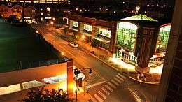
Commercial activities, however, take place mostly across the river in Lafayette. The largest commercial area in West Lafayette is the 90-acre (360,000 m2) Wabash Landing/Levee area, which has become a thriving urban-type district since the entire area was reconstructed and the Pedestrian Bridge to Lafayette replaced the old State Street bridge. The Levee features Wabash Landing, a complex containing shops, restaurants, coffee houses, a 9-screen movie theater, a Hilton Garden Inn, and the Riverside Skating Center.
News and media
West Lafayette residents use many of the news and media outlets located in its twin city of Lafayette. Media located in West Lafayette proper include:
- The Purdue Exponent. Purdue University's daily independent student newspaper serving Purdue, West Lafayette, and Lafayette. Newsroom and offices located just off campus on Northwestern Avenue in West Lafayette.
- WLFI-TV. Channel 18, a CBS affiliate
- WBAA Radio. (920AM, 101.3FM), a National Public Radio affiliate with studios located on the Purdue University campus
- WKHL Radio. (106.7FM)
Transportation
Public transportation in West Lafayette is managed by the Greater Lafayette Public Transportation Corporation.
Airports
Highways
-
 Interstate 65 to Gary, Indiana (near Chicago) and Indianapolis
 -
 US 52 to Joliet, Illinois (also near Chicago) and Indianapolis
 -
 US 231 to Rensselaer, Indiana and Owensboro, Kentucky
 -
 State Road 26 from Purdue University campus to Kokomo, Indiana
 -
 State Road 43 to Brookston, Indiana and Reynolds, Indiana
Railroads
- Amtrak (Lafayette station)
- CSX Transportation
- Kankakee, Beaverville and Southern Railroad
- Norfolk Southern Railway
Bus service
- CityBus local bus service by the Greater Lafayette Public Transportation Corporation (provides bus service around West Lafayette, Purdue campus, and Lafayette)
- Express Air Coach (provides express shuttle service between Purdue University and Chicago O'Hare International Airport)
- Lafayette Limo (provides express shuttle service to Indianapolis International Airport and Chicago O'Hare International Airport)
- Star of America (provides express shuttle service to the Indianapolis International Airport)
Points of interest

- Purdue University Horticulture Gardens
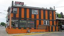
- Harry's Chocolate Shop, a bar that is part of the 19th century Von's Shops building
- Fort Ouiatenon, an early French trading post
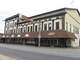
- Purdue State Bank, 1914 bank building designed by architect Louis Sullivan
- Samara (John E. Christian House), a Usonian home designed by architect Frank Lloyd Wright
- Celery Bog Nature Area and Lilly Nature Center
 Celery Bog Nature Area
 - Purdue Horticulture Park
Notable people
For notable residents associated with Purdue University, see List of Purdue University people.
For notable natives from the neighboring city Lafayette, Indiana, see that page.
- Brian Binnie - Test pilot for SpaceShipOne
- Bob Friend - Major League Baseball player
- Gen Fukunaga - Founder of Funimation Entertainment
- Anissa Jones - Actress, best known as Buffy on CBS' Family Affair
- Cleve Jones - Conceived the AIDS quilt
- Tom Kelly - Songwriter
- Drew Brees - NFL player
- Harry G. Leslie - Governor of Indiana
- Jay McDowell - Bassist for country music band BR549
- Toby Moskowitz - Financial economist
- Chike Okeafor - NFL player
- Eric Rodwell - Multiple world champion bridge player
- Erik Sabel - MLB player
- Randy Truitt - Member of the Indiana House of Representatives
See also
References
- 1 2 "G001 - Geographic Identifiers - 2010 Census Summary File 1". United States Census Bureau. Retrieved 2015-07-29.
- ↑ "US Board on Geographic Names". United States Geological Survey. 2007-10-25. Retrieved 2008-01-31.
- 1 2 "American FactFinder". United States Census Bureau. Retrieved 2012-12-11.
- ↑ "Population Estimates". Retrieved 2015-08-04.
- 1 2 "American FactFinder". United States Census Bureau. Retrieved 2008-01-31.
- ↑ "West Lafayette, Indiana". Geographic Names Information System. United States Geological Survey. Retrieved 2016-07-25.
- ↑ "2010 Population Finder". United States Census Bureau. Retrieved 2011-10-01.
- 1 2 "The History of West Lafayette". City of West Lafayette. Retrieved 2009-06-01.
- ↑ Robert Kriebel (1990). Old Lafayette volume 2: 1854-1876. Tippecanoe County Historical Association.
- ↑ http://www.westlafayette.in.gov/egov/docs/1225677108990.htm
- ↑ "West Lafayette council votes 6-1 for annexation plan". Lafayette Journal and Courier. Retrieved 2013-11-13.
- ↑ National Park Service (2010-07-09). "National Register Information System". National Register of Historic Places. National Park Service.
- ↑ "National Register of Historic Places Listings". Weekly List of Actions Taken on Properties: 4/09/12 through 4/13/12. National Park Service. 2012-04-20.
- ↑ "Monthly Averages for Lafayette, IN (47905)". The Weather Channel. Retrieved June 13, 2014.
- ↑ "Climatology of the United States No. 20: LAFAYETTE 8 S, IN 1971–2000" (PDF). National Oceanic and Atmospheric Administration. Retrieved November 19, 2011.
- ↑ "Annual Estimates of the Resident Population for Incorporated Places: April 1, 2010 to July 1, 2015". Retrieved July 2, 2016.
- ↑ http://www.westlafayette.in.gov/egov/docs/1414601282_221374.pdf
- ↑ "Census data for West Lafayette, Indiana". Retrieved 2006-09-09.
- ↑ "West Lafayette City Code". Retrieved 2006-09-12.
- ↑ "Student Enrollment and Demographics, West Lafayette Campus Fall 2011". Purdue University. Retrieved 2011-10-01.
- ↑ "West Lafayette Community School Corporation".
- ↑ http://www.indystar.com/article/20090108/LOCAL/901080425
- ↑ Purdue Research Foundation. "Purdue Research Park of West Lafayette". Retrieved 2009-06-01.
- ↑ "Preliminary State Unemployment Figures Released" (PDF). Indiana Workforce Development. August 23, 2006. Retrieved 2006-09-12.
Bibliography
- General R. P. DeHart, ed. (1909). Past and Present of Tippecanoe County Indiana. 1. Indianapolis: B. F. Bowen and Company. pp. 193, 462–464. Retrieved 2010-12-11.
Gallery

Snow in West Lafayette January 2014 
Snow and Malamute in West Lafayette March 2015
External links
- City of West Lafayette, Indiana website
- West Lafayette Community School Corporation Website
- WLFI-TV, News Channel 18 (Local TV station, owned by Media General)
Municipalities and communities of Tippecanoe County, Indiana, United States | ||
|---|---|---|
| Cities | ||
| Towns | ||
| Townships | ||
| CDPs | ||
| Other unincorporated communities |
| |
| Ghost towns | ||
| Footnotes | ‡This populated place also has portions in an adjacent county or counties | |