Clay County, Indiana
Coordinates: 39°24′N 87°07′W / 39.40°N 87.11°W
| Clay County, Indiana | |
|---|---|
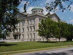 Clay County Courthouse, Brazil | |
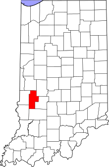 Location in the U.S. state of Indiana | |
 Indiana's location in the U.S. | |
| Founded | 1825 |
| Named for | Henry Clay |
| Seat | Brazil |
| Largest city | Brazil |
| Area | |
| • Total | 360.32 sq mi (933 km2) |
| • Land | 357.54 sq mi (926 km2) |
| • Water | 2.78 sq mi (7 km2), 0.77% |
| Population | |
| • (2010) | 26,890 |
| • Density | 75/sq mi (29.03/km²) |
| Congressional district | 8th |
| Time zone | Eastern: UTC-5/-4 |
| Website |
www |
| Footnotes: Indiana county number 11 | |
Clay County is a county located in the U.S. state of Indiana. As of 2010, the population was 26,890.[1] The county seat is Brazil.[2]
Clay County is included in the Terre Haute, Indiana, Metropolitan Statistical Area.
History
Clay County was formed in 1825. Its name is in honor of Henry Clay,[3] a famous antebellum American statesman.
The first Courthouse was built in the newly platted town of Bowling Green in 1828, soon after Clay County was formed by the Indiana legislature. It was a two-story structure of hand-hewn logs.
By the late 1830s Clay County had grown to the extent that the first Courthouse could no longer provide adequate facilities. Therefore, a second Courthouse was constructed near the first Courthouse. This was a two-story brick structure. This Courthouse served until destroyed by fire on the night of November 30, 1851.
Although some citizens believed Bowling Green was no longer the most practical or logical site for a new courthouse, the commissioners quickly decided to build the third courthouse on the site of the previous one in Bowling Green. Built of brick, at a cost of $11,000, and very similar to the previous courthouse, the new Courthouse began serving the county in the Fall of 1853.
By the 1860s the towns of Harmony, Knightsville, and Brazil were growing rapidly, due in part to their location along the National Road, and also because of the many coal companies in that section of the county. An effort to move the county seat of government to a more central location, which had begun in the 1850s, grew stronger creating controversy among citizens. In the 1860s citizens in the northern section of Clay County became more organized in their efforts. In 1871 brothers Robert and John Stewart donated a tract of land along the National Road in Brazil for proposed site of the new courthouse. The sum of $5,300 was also raised by citizens in the area to entice the commissioners to move the seat of government from Bowling Green to Brazil. This amount was reportedly the value of the existing courthouse and grounds, thus defusing opponents argument that abandoning the present courthouse would be a waste of taxpayers money. The relocation efforts, which began in 1871, were challenged in the Supreme Court. The relocation was finally granted in 1876.
In 1912 John W. Gaddis, a prominent architect in Vincennes, Indiana, entered into a contract with the County Commissioners to design, plan, and oversee the construction of a new courthouse. The construction bid of W.H. Bailey and Charles A. Koemer of Louisville, Kentucky was accepted in 1912 with the cornerstone being laid in the fall of 1912. Gaddis had successfully completed several others: in Fairfield and Robinson, Illinois: Perryville, Missouri and two in Indiana, the Putnam County Courthouse in Greencastle (1905) and the Huntington County Courthouse (1906) in Huntington, which are also in Classical Revival mode.
The Clay County Courthouse built in 1913-1914, is one of the most historically and architecturally significant buildings in Brazil and Clay County, Indiana. Built in Classical Revival style of architecture, it is the only building in Clay County holding county government offices and records. It is also located alongside the famed National Road (Cumberland Trail). The present Courthouse is the fifth Courthouse to serve the people of Clay County.
Geography
According to the 2010 census, the county has a total area of 360.32 square miles (933.2 km2), of which 357.54 square miles (926.0 km2) (or 99.23%) is land and 2.78 square miles (7.2 km2) (or 0.77%) is water.[4]
Cities and towns
Incorporated
Unincorporated
Extinct
|
Townships
Adjacent counties
- Parke County (north)
- Putnam County (northeast)
- Owen County (southeast)
- Greene County (south)
- Sullivan County (southwest)
- Vigo County (west)
Transportation
Major highways
Airport
The county contains one public-use airport: Brazil Clay County Airport (0I2), serving Brazil, Indiana.[5]
Climate and weather
| Brazil, Indiana | ||||||||||||||||||||||||||||||||||||||||||||||||||||||||||||
|---|---|---|---|---|---|---|---|---|---|---|---|---|---|---|---|---|---|---|---|---|---|---|---|---|---|---|---|---|---|---|---|---|---|---|---|---|---|---|---|---|---|---|---|---|---|---|---|---|---|---|---|---|---|---|---|---|---|---|---|---|
| Climate chart (explanation) | ||||||||||||||||||||||||||||||||||||||||||||||||||||||||||||
| ||||||||||||||||||||||||||||||||||||||||||||||||||||||||||||
| ||||||||||||||||||||||||||||||||||||||||||||||||||||||||||||
In recent years, average temperatures in Brazil have ranged from a low of 19 °F (−7 °C) in January to a high of 87 °F (31 °C) in July, although a record low of −25 °F (−32 °C) was recorded in January 1994 and a record high of 109 °F (43 °C) was recorded in July 1936. Average monthly precipitation ranged from 2.25 inches (57 mm) in February to 4.89 inches (124 mm) in July.[6]
Government
The county government is a constitutional body, and is granted specific powers by the Constitution of Indiana, and by the Indiana Code.
County Council: The county council is the legislative branch of the county government and controls all the spending and revenue collection in the county. Representatives are elected from county districts. The council members serve four-year terms. They are responsible for setting salaries, the annual budget, and special spending. The council also has limited authority to impose local taxes, in the form of an income and property tax that is subject to state level approval, excise taxes, and service taxes.[7][8]
Board of Commissioners: The executive body of the county is made of a board of commissioners. The commissioners are elected county-wide, in staggered terms, and each serves a four-year term. One of the commissioners, typically the most senior, serves as president. The commissioners are charged with executing the acts legislated by the council, collecting revenue, and managing the day-to-day functions of the county government.[7][8]
Court: The county maintains a small claims court that can handle some civil cases. The judge on the court is elected to a term of four years and must be a member of the Indiana Bar Association. The judge is assisted by a constable who is also elected to a four-year term. In some cases, court decisions can be appealed to the state-level circuit court.[8]
County Officials: The county has several other elected offices, including sheriff, coroner, auditor, treasurer, recorder, surveyor, and circuit court clerk. Each of these elected officers serves a term of four years and oversees a different part of county government. Members elected to county government positions are required to declare a party affiliation and to be residents of the county.[8]
Clay County is part of Indiana's 8th congressional district; Indiana Senate districts 38 and 39;[9] and Indiana House of Representatives districts 42, 44 and 46.[10]
Demographics
| Historical population | |||
|---|---|---|---|
| Census | Pop. | %± | |
| 1830 | 1,616 | — | |
| 1840 | 5,567 | 244.5% | |
| 1850 | 7,944 | 42.7% | |
| 1860 | 12,161 | 53.1% | |
| 1870 | 19,084 | 56.9% | |
| 1880 | 25,854 | 35.5% | |
| 1890 | 30,536 | 18.1% | |
| 1900 | 34,285 | 12.3% | |
| 1910 | 32,535 | −5.1% | |
| 1920 | 29,447 | −9.5% | |
| 1930 | 26,479 | −10.1% | |
| 1940 | 25,365 | −4.2% | |
| 1950 | 23,918 | −5.7% | |
| 1960 | 24,207 | 1.2% | |
| 1970 | 23,933 | −1.1% | |
| 1980 | 24,862 | 3.9% | |
| 1990 | 24,705 | −0.6% | |
| 2000 | 26,556 | 7.5% | |
| 2010 | 26,890 | 1.3% | |
| Est. 2015 | 26,503 | [11] | −1.4% |
| U.S. Decennial Census[12] 1790-1960[13] 1900-1990[14] 1990-2000[15] 2010-2013[1] | |||
As of the 2010 United States Census, there were 26,890 people, 10,447 households, and 7,454 families residing in the county.[16] The population density was 75.2 inhabitants per square mile (29.0/km2). There were 11,703 housing units at an average density of 32.7 per square mile (12.6/km2).[4] The racial makeup of the county was 97.8% white, 0.3% black or African American, 0.2% Asian, 0.2% American Indian, 0.5% from other races, and 0.9% from two or more races. Those of Hispanic or Latino origin made up 1.1% of the population.[16] In terms of ancestry, 29.2% were German, 20.2% were American, 12.8% were Irish, and 11.0% were English.[17]
Of the 10,447 households, 33.4% had children under the age of 18 living with them, 55.9% were married couples living together, 10.7% had a female householder with no husband present, 28.6% were non-families, and 24.0% of all households were made up of individuals. The average household size was 2.54 and the average family size was 2.99. The median age was 39.9 years.[16]
The median income for a household in the county was $47,697 and the median income for a family was $52,907. Males had a median income of $40,671 versus $31,331 for females. The per capita income for the county was $20,569. About 9.0% of families and 12.5% of the population were below the poverty line, including 21.9% of those under age 18 and 6.7% of those age 65 or over.[18]
See also
References
- Specific
- 1 2 "Clay County QuickFacts". United States Census Bureau. Retrieved 2011-09-17.
- ↑ "Find a County". National Association of Counties. Archived from the original on 2011-05-31. Retrieved 2011-06-07.
- ↑ Gannett, Henry (1905). The Origin of Certain Place Names in the United States. Govt. Print. Off. p. 83.
- 1 2 "Population, Housing Units, Area, and Density: 2010 - County". United States Census Bureau. Retrieved 2015-07-10.
- ↑ Public and Private Airports, Clay County, Indiana
- 1 2 "Monthly Averages for Brazil, Indiana". The Weather Channel. Retrieved 2011-01-27.
- 1 2 Indiana Code. "Title 36, Article 2, Section 3". IN.gov. Retrieved 2008-09-16.
- 1 2 3 4 Indiana Code. "Title 2, Article 10, Section 2" (PDF). IN.gov. Retrieved 2008-09-16.
- ↑ "Indiana Senate Districts". State of Indiana. Retrieved 2011-01-23.
- ↑ "Indiana House Districts". State of Indiana. Retrieved 2011-01-23.
- ↑ "County Totals Dataset: Population, Population Change and Estimated Components of Population Change: April 1, 2010 to July 1, 2015". Retrieved July 2, 2016.
- ↑ "U.S. Decennial Census". United States Census Bureau. Archived from the original on May 11, 2015. Retrieved July 10, 2014.
- ↑ "Historical Census Browser". University of Virginia Library. Retrieved July 10, 2014.
- ↑ "Population of Counties by Decennial Census: 1900 to 1990". United States Census Bureau. Retrieved July 10, 2014.
- ↑ "Census 2000 PHC-T-4. Ranking Tables for Counties: 1990 and 2000" (PDF). United States Census Bureau. Retrieved July 10, 2014.
- 1 2 3 "DP-1 Profile of General Population and Housing Characteristics: 2010 Demographic Profile Data". United States Census Bureau. Retrieved 2015-07-10.
- ↑ "DP02 SELECTED SOCIAL CHARACTERISTICS IN THE UNITED STATES – 2006-2010 American Community Survey 5-Year Estimates". United States Census Bureau. Retrieved 2015-07-10.
- ↑ "DP03 SELECTED ECONOMIC CHARACTERISTICS – 2006-2010 American Community Survey 5-Year Estimates". United States Census Bureau. Retrieved 2015-07-10.
- General
- Clay County Interim Report by Historic Landmarks Foundation of Indiana
External links
 |
Parke County | Putnam County | | |
| Vigo County | |
|||
| ||||
| | ||||
| Sullivan County | Greene County | Owen County |
Municipalities and communities of Clay County, Indiana, United States | ||
|---|---|---|
| City | ||
| Towns | ||
| Townships | ||
| CDP | ||
| Other unincorporated communities |
| |
| Ghost towns | ||
| Footnotes | ‡This populated place also has portions in an adjacent county or counties | |
