Newton County, Indiana
| Newton County, Indiana | |
|---|---|
| County | |
|
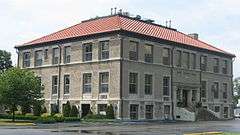
Newton County Courthouse in Kentland | |
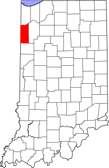 Location in the state of Indiana | |
 Indiana's location in the U.S. | |
| Coordinates: 40°57′N 87°24′W / 40.950°N 87.400°WCoordinates: 40°57′N 87°24′W / 40.950°N 87.400°W | |
| Country |
|
| State |
|
| Region | Northwest Indiana |
| Metro area | Chicago Metropolitan |
| Organized | February 7, 1835 |
| Abolished | 1839 |
| Re-organized | December 8, 1859 |
| Named for | Sgt. John Newton |
| County seat | Kentland |
| Largest town |
Kentland (population and total area) |
| Incorporated Municipalities | |
| Government | |
| • Type | County |
| • Body | Board of Commissioners |
| • Commissioner | Kyle Conrad (1st) |
| • Commissioner | Timothy Drenth (2nd) |
| • Commissioner | Mickey Read (3rd) |
| Area | |
| • County | 403.44 sq mi (1,044.9 km2) |
| • Land | 401.76 sq mi (1,040.6 km2) |
| • Water | 1.68 sq mi (4.4 km2) |
| • Metro | 10,874 sq mi (28,160 km2) |
| Area rank | 43rd largest county in Indiana |
| • Region | 2,726 sq mi (7,060 km2) |
| Elevation | 692 ft (211 m) |
| Population (2010) | |
| • County | 14,244 |
| • Estimate (2015) | 14,008 |
| • Rank |
82nd largest county in Indiana 2,165th largest county in U.S.[1] |
| • Density | 35.5/sq mi (13.7/km2) |
| • Metro | 9,522,434 |
| • Region | 819,537 |
| Time zone | Central (UTC-6) |
| • Summer (DST) | Central (UTC-5) |
| ZIP Codes | 46310, 46349, 47922, 47942-43, 47948, 47951, 47963, 47978 |
| Area code | 219 |
| Congressional district | 4th |
| Indiana Senate district | 6th |
| Indiana House of Representatives districts | 15th and 19th |
| FIPS code | 18-111 |
| GNIS feature ID | 0450376 |
| Interstate and U.S. Routes |
|
| State Routes |
|
| Airport |
|
| Waterways | Iroquois River – Kankakee River |
| Website | www.newtoncounty.in.gov |
| |
| Demographics (2010)[2] | |||
|---|---|---|---|
| White | Black | Asian | |
| 96.2% | 0.4% | 0.3% | |
| Islander | Native | Other | Hispanic (any race) |
| 0.0% | 0.3% | 2.8% | 5.0% |
Newton County is a county located in the U.S. state of Indiana. As of 2010, the population was 14,244. This county is part of Northwest Indiana as well as the Chicago metropolitan area.[3] The county seat is Kentland.[4] The county is divided into 10 townships which provide local services.[5][6]
History
The original Newton County was formed by statute on February 7, 1835, and was a roughly square area some 30 miles on a side, encompassing what is now the northern half of the county, the northern half of Jasper County, and a large section to the north. The northern border was cut back to the Kankakee River on February 1, 1836, with all land north of the Kankakee River going to Lake and Porter counties. The county was abolished and combined with Jasper County in 1839. On December 8, 1859, the county was re-created and the borders were redrawn to essentially their current state.
Newton County is named after Sgt. John Newton, who served under Gen. Francis Marion (the "Swamp Fox") in the American Revolutionary War. It is adjacent to Jasper County, which was named after Sgt. William Jasper, whose story is similar. At least four other states, Georgia, Mississippi, Missouri and Texas, have adjacent Jasper and Newton Counties, as though these two were remembered as a pair.[7]
Upon its re-creation, Newton County was the last county to be organized in Indiana.
Geography
According to the 2010 census, the county has a total area of 403.44 square miles (1,044.9 km2), of which 401.76 square miles (1,040.6 km2) (or 99.58%) is land and 1.68 square miles (4.4 km2) (or 0.42%) is water.[8]
Newton County is the site of the Kentland crater, a probable meteorite impact crater located between Kentland and Goodland.
J.C. Murphy Lake is at the center of Willow Slough Fish and Wildlife Area.
Major highways
 Interstate 65
 U.S. Route 24
 U.S. Route 41
 U.S. Route 52
 State Road 10
 State Road 14
 State Road 16
 State Road 55
 State Road 71
 State Road 114
Railroads
Adjacent counties
- Lake County (north)
- Jasper County (east)
- Benton County (south/ET Border)
- Iroquois County, Illinois (west)
- Kankakee County, Illinois (northwest)
Municipalities
The municipalities in Newton County, and their populations as of the 2010 Census, are:
Towns
Census-designated places
- Lake Village – 765
- Roselawn – 4,131
Townships
The 10 townships of Newton County, with their housing units as of the 2010 Census, are:
Climate and weather
| Kentland, Indiana | ||||||||||||||||||||||||||||||||||||||||||||||||||||||||||||
|---|---|---|---|---|---|---|---|---|---|---|---|---|---|---|---|---|---|---|---|---|---|---|---|---|---|---|---|---|---|---|---|---|---|---|---|---|---|---|---|---|---|---|---|---|---|---|---|---|---|---|---|---|---|---|---|---|---|---|---|---|
| Climate chart (explanation) | ||||||||||||||||||||||||||||||||||||||||||||||||||||||||||||
| ||||||||||||||||||||||||||||||||||||||||||||||||||||||||||||
| ||||||||||||||||||||||||||||||||||||||||||||||||||||||||||||
In recent years, average temperatures in Kentland have ranged from a low of 14 °F (−10 °C) in January to a high of 85 °F (29 °C) in July, with a record low of −25 °F (−32 °C) recorded in January 1985 and a record high of 104 °F (40 °C) recorded in June 1988. Average monthly precipitation ranged from 1.60 inches (41 mm) in February to 4.51 inches (115 mm) in June.[9]
Government
The county government is a constitutional body granted specific powers by the Constitution of Indiana and the Indiana Code. The county council is the legislative branch of the county government and controls all spending and revenue collection. Representatives are elected from county districts. The council members serve four-year terms and are responsible for setting salaries, the annual budget and special spending. The council also has limited authority to impose local taxes, in the form of an income and property tax that is subject to state level approval, excise taxes and service taxes.[10][11]
The executive body of the county is made of a board of commissioners. The commissioners are elected county-wide, in staggered terms, and each serves a four-year term. One of the commissioners, typically the most senior, serves as president. The commissioners are charged with executing the acts legislated by the council, collecting revenue and managing day-to-day functions of the county government.[10][11]
The county maintains a small claims court that can handle some civil cases. The judge on the court is elected to a term of four years and must be a member of the Indiana Bar Association. The judge is assisted by a constable who is elected to a four-year term. In some cases, court decisions can be appealed to the state level circuit court.[11]
The county has several other elected offices, including sheriff, coroner, auditor, treasurer, recorder, surveyor and circuit court clerk. Each of these elected officers serves a term of four years and oversees a different part of county government. Members elected to county government positions are required to declare party affiliations and be residents of the county.[11]
Each of the townships has a trustee who administers rural fire protection and ambulance service, provides poor relief and manages cemetery care, among other duties.[6] The trustee is assisted in these duties by a three-member township board. The trustees and board members are elected to four-year terms.[12]
Newton County is part of Indiana's 1st congressional district and in 2008 was represented by Pete Visclosky in the United States Congress.[13] It is part of Indiana Senate district 6[14] and Indiana House of Representatives districts 15 and 19.[15]
Demographics
| Historical population | |||
|---|---|---|---|
| Census | Pop. | %± | |
| 1860 | 2,360 | — | |
| 1870 | 5,829 | 147.0% | |
| 1880 | 8,167 | 40.1% | |
| 1890 | 8,803 | 7.8% | |
| 1900 | 10,448 | 18.7% | |
| 1910 | 10,504 | 0.5% | |
| 1920 | 10,144 | −3.4% | |
| 1930 | 9,841 | −3.0% | |
| 1940 | 10,775 | 9.5% | |
| 1950 | 11,006 | 2.1% | |
| 1960 | 11,502 | 4.5% | |
| 1970 | 11,606 | 0.9% | |
| 1980 | 14,844 | 27.9% | |
| 1990 | 13,551 | −8.7% | |
| 2000 | 14,566 | 7.5% | |
| 2010 | 14,244 | −2.2% | |
| Est. 2015 | 14,008 | [16] | −1.7% |
| U.S. Decennial Census[17] 1790-1960[18] 1900-1990[19] 1990-2000[20] 2010-2013[3] | |||
As of the 2010 United States Census, there were 14,244 people, 5,503 households, and 3,945 families residing in the county.[21] The population density was 35.5 inhabitants per square mile (13.7/km2). There were 6,030 housing units at an average density of 15.0 per square mile (5.8/km2).[8] The racial makeup of the county was 96.2% white, 0.4% black or African American, 0.3% Asian, 0.3% American Indian, 1.8% from other races, and 1.1% from two or more races. Those of Hispanic or Latino origin made up 5.0% of the population.[21] In terms of ancestry, 30.4% were German, 16.9% were Irish, 11.0% were English, 8.1% were Polish, 7.6% were Dutch, and 6.5% were American.[22]
Of the 5,503 households, 31.1% had children under the age of 18 living with them, 57.3% were married couples living together, 8.7% had a female householder with no husband present, 28.3% were non-families, and 23.8% of all households were made up of individuals. The average household size was 2.56 and the average family size was 3.00. The median age was 42.4 years.[21]
The median income for a household in the county was $47,697 and the median income for a family was $60,242. Males had a median income of $45,389 versus $29,891 for females. The per capita income for the county was $24,055. About 4.8% of families and 8.2% of the population were below the poverty line, including 12.0% of those under age 18 and 5.3% of those age 65 or over.[23]
Education
Public schools in Newton County are administered by two districts:
- North Newton School Corporation
- South Newton School Corporation
High Schools and Middle Schools
- North Newton Junior-Senior High School
- South Newton High School
- South Newton Middle School
Elementary Schools
- Lake Village Elementary School
- Lincoln Elementary School
- Morocco Elementary School
- South Newton Elementary School
See also
Bibliography
- George Pence and Nellie C. Armstrong (1933). Indiana Boundaries: Territory, State, and County. Indiana Historical Society.
References
- ↑ "USA Counties in Profile". STATS Indiana. Retrieved 2014-06-29.
- ↑ U.S. Census Bureau. American Community Survey, Profile of General Population and Housing Characteristics 2010, Table DP-1, 2010 Demographic Profile Data. American FactFinder. Retrieved 2014-06-29.
- 1 2 "Newton County QuickFacts". United States Census Bureau. Retrieved 2011-09-25.
- ↑ "Find a County – Newton County, IN". National Association of Counties. Retrieved 2011-11-15.
- ↑ "Newton". Indiana Township Association. Retrieved 2011-11-15.
- 1 2 "Duties". United Township Association of Indiana. Retrieved 2011-01-06.
- ↑ De Witt Clinton Goodrich & Charles Richard Tuttle (1875). An Illustrated History of the State of Indiana. Indiana: R. S. Peale & co. p. 581.
- 1 2 "Population, Housing Units, Area, and Density: 2010 - County". United States Census Bureau. Retrieved 2015-07-10.
- 1 2 "Monthly Averages for Kentland, Indiana". The Weather Channel. Retrieved 2011-01-27.
- 1 2 Indiana Code. "Title 36, Article 2, Section 3". Government of Indiana. Retrieved 2008-09-16.
- 1 2 3 4 Indiana Code. "Title 2, Article 10, Section 2" (PDF). Government of Indiana. Retrieved 2008-09-16.
- ↑ "Government". United Township Association of Indiana. Retrieved 2011-01-06.
- ↑ "US Congressman Pete Visclosky". US Congress. Retrieved 2008-10-08.
- ↑ "Indiana Senate Districts". State of Indiana. Retrieved 2011-07-14.
- ↑ "Indiana House Districts". State of Indiana. Retrieved 2011-07-14.
- ↑ "County Totals Dataset: Population, Population Change and Estimated Components of Population Change: April 1, 2010 to July 1, 2015". Retrieved July 2, 2016.
- ↑ "U.S. Decennial Census". United States Census Bureau. Retrieved July 10, 2014.
- ↑ "Historical Census Browser". University of Virginia Library. Retrieved July 10, 2014.
- ↑ "Population of Counties by Decennial Census: 1900 to 1990". United States Census Bureau. Retrieved July 10, 2014.
- ↑ "Census 2000 PHC-T-4. Ranking Tables for Counties: 1990 and 2000" (PDF). United States Census Bureau. Retrieved July 10, 2014.
- 1 2 3 "DP-1 Profile of General Population and Housing Characteristics: 2010 Demographic Profile Data". United States Census Bureau. Retrieved 2015-07-10.
- ↑ "DP02 SELECTED SOCIAL CHARACTERISTICS IN THE UNITED STATES – 2006-2010 American Community Survey 5-Year Estimates". United States Census Bureau. Retrieved 2015-07-10.
- ↑ "DP03 SELECTED ECONOMIC CHARACTERISTICS – 2006-2010 American Community Survey 5-Year Estimates". United States Census Bureau. Retrieved 2015-07-10.
External links
 |
Kankakee County, Illinois | Lake County | | |
| Iroquois County, Illinois | |
Jasper County | ||
| ||||
| | ||||
| Benton County |
Municipalities and communities of Newton County, Indiana, United States | ||
|---|---|---|
| Towns | ||
| Townships | ||
| CDPs | ||
| Other unincorporated communities |
| |
| Footnotes | ‡This populated place also has portions in an adjacent county or counties | |
| Major city |  | |
|---|---|---|
| Cities (over 30,000 in 2010) | ||
| Towns and villages (over 30,000 in 2010) |
| |
| Counties | ||
| Regions | ||
| Sub-regions | ||
