Shelbyville, Indiana
| Shelbyville, Indiana | |
|---|---|
| City | |
|
Aerial photo of Shelbyville | |
| Motto: "Pride in Progress" | |
 Location in the state of Indiana | |
| Coordinates: 39°31′19″N 85°46′35″W / 39.52194°N 85.77639°WCoordinates: 39°31′19″N 85°46′35″W / 39.52194°N 85.77639°W | |
| Country | United States |
| State | Indiana |
| County | Shelby |
| Township | Addison |
| Government | |
| • Mayor | Tom DeBaun (D) |
| Area[1] | |
| • Total | 11.84 sq mi (30.67 km2) |
| • Land | 11.56 sq mi (29.94 km2) |
| • Water | 0.28 sq mi (0.73 km2) 2.36% |
| Elevation[2] | 764 ft (233 m) |
| Population (2010)[3] | |
| • Total | 19,191 |
| • Estimate (2012[4]) | 19,159 |
| • Density | 1,660.1/sq mi (641.0/km2) |
| Time zone | EST (UTC-5) |
| • Summer (DST) | EDT (UTC-4) |
| ZIP code | 46176 |
| Area code(s) | 317 |
| FIPS code | 18-69318[5] |
| GNIS feature ID | 443347 |
| Interstate Highways | |
| U.S. Highways | |
| Major State Roads | |
| Waterways | Little Blue River, Big Blue River |
| Airports | Shelbyville Municipal Airport |
| Website | http://www.cityofshelbyvillein.com/ |
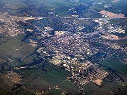
Shelbyville is a city in Addison Township, Shelby County, in the U.S. state of Indiana and is the county seat.[6] The population was 19,191 as of the 2010 census.[7]
History
In 1818, the land that would become Shelbyville was ceded to the United States by the Miami tribe in the Treaty of St. Mary's. Also in 1818, the backwoodsman Jacob Whetzel and a party cut a trail through this "New Purchase" from the Whitewater River at Laurel due west to the White River at Waverly. This trail became known as Whetzel's Trace and was the first east-west road into the New Purchase of central Indiana. Whetzel's Trace was cut just 4 miles north of site of Shelbyville and proved important in the settlement of Shelby County.[8]
Shelbyville was platted in 1822.[9] Shelbyville was named in honor of Isaac Shelby, the first and fifth Governor of Kentucky and soldier in Lord Dunmore's War, the Revolutionary War, and the War of 1812.[10] The town incorporated January 21, 1850.[11]
The Shelbyville post office has been in operation since 1823.[12]
The city charter received at that time was destroyed in the City Hall fire on January 1, 1928.
A railroad was built connecting Shelbyville to Indianapolis in the late 1830s, the first railroad in the state, that later expanded to connect to Madison and Jeffersonville.
Allegheny Airlines Flight 853 crashed on September 9, 1969 near Fairland. Nearly thirty of the 82 people killed were never identified and were buried in a mass grave in Shelbyville.[13]
John Hamilton House, Lora B. Pearson School, Porter Pool Bathhouse, Shelbyville Commercial Historic District, Shelby County Courthouse, Shelbyville High School, and West Side Historic District are listed on the National Register of Historic Places.[14][15]
Geography
Shelbyville is located in Central Indiana and within the Indianapolis metropolitan area. It is 26 miles (42 km) southeast of Indianapolis. The city is at the fork of the Little Blue and Big Blue Rivers.
According to the 2010 census, Shelbyville has a total area of 11.845 square miles (30.68 km2), of which 11.56 square miles (29.94 km2) (or 97.59%) is land and 0.285 square miles (0.74 km2) (or 2.41%) is water.[1]
Climate
Shelbyville has a humid continental climate (Köppen climate classification Dfa) experiencing four distinct seasons. Annual precipitation: 40.14 inches Average temperature: 54.14 degrees
Education
Shelbyville Central Schools consists of Shelbyville Senior High School, Shelbyville Middle School, Coulston Elementary, Loper Elementary, and Hendricks Elementary. The high school and middle school's mascot is Golden Bears. Coulston is the Comets, Hendricks is the Hurricanes and Loper is the Bulldogs.
St. Joseph Elementary School is a private school, associated with St. Joseph Catholic Church, in Shelbyville.
Demographics
| Historical population | |||
|---|---|---|---|
| Census | Pop. | %± | |
| 1840 | 446 | — | |
| 1850 | 995 | 123.1% | |
| 1860 | 1,960 | 97.0% | |
| 1870 | 2,731 | 39.3% | |
| 1880 | 3,745 | 37.1% | |
| 1890 | 5,451 | 45.6% | |
| 1900 | 7,169 | 31.5% | |
| 1910 | 9,500 | 32.5% | |
| 1920 | 9,701 | 2.1% | |
| 1930 | 10,618 | 9.5% | |
| 1940 | 10,791 | 1.6% | |
| 1950 | 11,734 | 8.7% | |
| 1960 | 14,317 | 22.0% | |
| 1970 | 15,094 | 5.4% | |
| 1980 | 14,989 | −0.7% | |
| 1990 | 15,336 | 2.3% | |
| 2000 | 17,951 | 17.1% | |
| 2010 | 19,191 | 6.9% | |
| Est. 2015 | 19,133 | [16] | −0.3% |
| Source: US Census Bureau | |||
2010 census
As of the census[3] of 2010, there were 19,191 people, 7,682 households, and 4,848 families residing in the city. The population density was 1,660.1 inhabitants per square mile (641.0/km2). There were 8,658 housing units at an average density of 749.0 per square mile (289.2/km2). The racial makeup of the city was 91.9% White, 1.9% African American, 0.2% Native American, 1.0% Asian, 3.2% from other races, and 1.7% from two or more races. Hispanic or Latino of any race were 7.1% of the population.
There were 7,682 households of which 34.3% had children under the age of 18 living with them, 42.6% were married couples living together, 13.6% had a female householder with no husband present, 6.9% had a male householder with no wife present, and 36.9% were non-families. 30.7% of all households were made up of individuals and 12.1% had someone living alone who was 65 years of age or older. The average household size was 2.43 and the average family size was 3.00.
The median age in the city was 35.9 years. 25.5% of residents were under the age of 18; 9.4% were between the ages of 18 and 24; 27.2% were from 25 to 44; 24.8% were from 45 to 64; and 13% were 65 years of age or older. The gender makeup of the city was 48.8% male and 51.2% female.
2000 census
As of the census[5] of 2000, there were 17,951 people, 7,307 households, and 4,654 families residing in the city. The population density was 2,023.0 people per square mile (781.4/km²). There were 7,930 housing units at an average density of 893.7 per square mile (345.2/km²). The racial makeup of the city was 95.28% White, 1.58% African American, 0.15% Native American, 1.16% Asian, 0.02% Pacific Islander, 0.90% from other races, and 0.91% from two or more races. Hispanic or Latino of any race were 1.91% of the population.
There were 7,307 households out of which 32.3% had children under the age of 18 living with them, 46.3% were married couples living together, 12.5% had a female householder with no husband present, and 36.3% were non-families. 30.3% of all households were made up of individuals and 12.2% had someone living alone who was 65 years of age or older. The average household size was 2.39 and the average family size was 2.96. In the city the population was spread out with 26.2% under the age of 18, 9.5% from 18 to 24, 31.6% from 25 to 44, 19.3% from 45 to 64, and 13.3% who were 65 years of age or older. The median age was 34 years. For every 100 females there were 94.8 males. For every 100 females age 18 and over, there were 92.4 males.
The median income for a household in the city was $36,824, and the median income for a family was $46,379. Males had a median income of $34,550 versus $24,331 for females. The per capita income for the city was $18,670. About 6.1% of families and 9.1% of the population were below the poverty line, including 10.8% of those under age 18 and 11.6% of those age 65 or over.
Notable people
- Sandy Allen, listed as tallest living female (7'7") by Guinness World Records, until her death on August 13, 2008 at age 53
- James "Bucky" Barnes, fictional character from the Marvel comics universe and former Captain America was born in Shelbyville.
- William Garrett, He led Shelbyville to the Indiana state championship in 1947, was Indiana Mr. Basketball of 1947 and first African-American basketball player in the Big Ten Conference for Indiana University, played for the Boston Celtics and Harlem Globetrotters
- Thomas Hendricks, 21st Vice President of the United States under Grover Cleveland for 1 year only in 1885
- Victor Higgins (1884-1949), painter, studied at the Art Institute in Chicago, moved to Taos, NM; has a painting in the Eiteljorg Museum
- John W. Hill (1890-1977), founder of PR firm Hill & Knowlton in Cleveland in 1927
- Charles Major (1856-1913), novelist, In 1953, Major's debut 1898 novel When Knighthood Was in Flower was remade into a film by Walt Disney Pictures. He also wrote Dorothy Vernon of Haddon Hall which was made into a 1924 silent historical drama (film).
- Edna Parker (b. 1893), the oldest living person from August 13, 2007 until her death on November 26, 2008 at the age of 115 years
- Mike Phipps, former Cleveland Browns and Chicago Bears (1977–1981) quarterback, also played for Purdue University
- James Pierce, actor, movies include silent film Tarzan and the Golden Lion in 1927
- Wilbur Shaw, three-time Indianapolis 500 winner in 1937, 1939, and 1940.
- W. Roland Stine, educator and politician
- Kid Quill, rapper.
References
- 1 2 "G001 - Geographic Identifiers - 2010 Census Summary File 1". United States Census Bureau. Retrieved 2015-07-29.
- ↑ "US Board on Geographic Names". United States Geological Survey. 2007-10-25. Retrieved 2008-01-31.
- 1 2 "American FactFinder". United States Census Bureau. Retrieved 2012-12-11.
- ↑ "Population Estimates". United States Census Bureau. Retrieved 2013-06-25.
- 1 2 "American FactFinder". United States Census Bureau. Retrieved 2008-01-31.
- ↑ "Shelbyville, Indiana". Geographic Names Information System. United States Geological Survey. Retrieved 2016-11-08.
- ↑ "Find a County". National Association of Counties. Retrieved 2011-06-07.
- ↑ Wilson, George R. Early Indiana Trails and Surveys. The Society of Indiana Pioneers. pp. 51–53.
- ↑ History of Shelby County, Indiana: From the Earliest Time to the Present, with Biographical Sketches, Notes, Etc. Brant & Fuller. 1887. p. 407.
- ↑ Couch, Ernie; Couch, Jill (23 October 2000). Indiana Trivia. Thomas Nelson. p. 18. ISBN 978-1-4185-7362-1.
- ↑ Chadwick, Edward H. (1909). Chadwick's History of Shelby County, Indiana. B.F. Bowen. p. 281.
- ↑ "Shelby County". Jim Forte Postal History. Retrieved November 8, 2016.
- ↑ Residents recall deadly plane crash near London
- ↑ National Park Service (2010-07-09). "National Register Information System". National Register of Historic Places. National Park Service.
- ↑ "National Register of Historic Places Listings". Weekly List of Actions Taken on Properties: 12/12/11 through 12/16/11. National Park Service. 2011-12-23.
- ↑ "Annual Estimates of the Resident Population for Incorporated Places: April 1, 2010 to July 1, 2015". Retrieved July 2, 2016.
External links
Municipalities and communities of Shelby County, Indiana, United States | ||
|---|---|---|
| City | ||
| Towns | ||
| Townships | ||
| CDP | ||
| Other unincorporated communities |
| |
| Footnotes | ‡This populated place also has portions in an adjacent county or counties | |