Allen County, Indiana
| Allen County, Indiana | |
|---|---|
 Allen County Courthouse in Fort Wayne | |
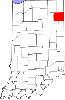 Location in the U.S. state of Indiana | |
 Indiana's location in the U.S. | |
| Founded | April 1, 1824 |
| Named for | John Allen |
| Seat | Fort Wayne |
| Largest city | Fort Wayne |
| Area | |
| • Total | 660.02 sq mi (1,709 km2) |
| • Land | 657.31 sq mi (1,702 km2) |
| • Water | 2.71 sq mi (7 km2), 0.41% |
| Population | |
| • (2010) | 355,329 |
| • Density | 541/sq mi (208.73/km²) |
| Congressional district | 3rd |
| Time zone | Eastern: UTC-5/-4 |
| Website |
www |
|
Footnotes:
| |
Allen County is a county in the U.S. state of Indiana. As of the 2010 Census, the population was 355,329,[1] making it the third-most populous county in Indiana. The county seat and largest city is Fort Wayne, Indiana.[2]
Allen County is included in the Fort Wayne Metropolitan Statistical Area and the Fort Wayne–Huntington–Auburn Combined Statistical Area. Allen County is the cultural and economic center of northeastern Indiana. The county is within a 200-mile (320 km) radius of major population centers, including Chicago, Cincinnati, Cleveland, Columbus, Detroit, Indianapolis, Louisville, Milwaukee, and Ontario, Canada, and within a one-day drive of one-third of the U.S. population and one-fifth of Canadians.[3]
Occupied for thousands of years by cultures of indigenous peoples, Allen County was organized by European Americans on December 17, 1823, from Delaware and Randolph counties; and formed April 1, 1824. The county is named for Colonel John Allen, an attorney and Kentucky state senator who was killed in the War of 1812.[4] Fort Wayne, founded at the confluences of the Maumee, St. Joseph, and St. Marys rivers, was chosen as the county seat in May 1824.
Geography

According to the 2010 census, the county has a total area of 660.02 square miles (1,709.4 km2), the largest county in Indiana, of which 657.31 square miles (1,702.4 km2) (or 99.59%) is land and 2.71 square miles (7.0 km2) (or 0.41%) is water.[5]
Adjacent counties
- Noble County (northwest)
- DeKalb County (northeast)
- Defiance County, Ohio (northeast)
- Paulding County, Ohio (east)
- Van Wert County, Ohio (southeast)
- Adams County (southeast)
- Wells County (southwest)
- Huntington County (southwest)
- Whitley County (west)
Municipalities
Cities
Towns
- Grabill
- Huntertown
- Leo-Cedarville
- Monroeville
- Zanesville (partial)
Census-designated places
Unincorporated communities
Extinct
Townships
- Aboite Township
- Adams Township
- Cedar Creek Township
- Eel River Township
- Jackson Township
- Jefferson Township
- Lafayette Township
- Lake Township
- Madison Township
- Marion Township
- Maumee Township
- Milan Township
- Monroe Township
- Perry Township
- Pleasant Township
- Scipio Township
- Springfield Township
- St. Joseph Township
- Washington Township
- Wayne Township
Demographics

| Historical population | |||
|---|---|---|---|
| Census | Pop. | %± | |
| 1830 | 996 | — | |
| 1840 | 5,942 | 496.6% | |
| 1850 | 16,919 | 184.7% | |
| 1860 | 29,328 | 73.3% | |
| 1870 | 43,494 | 48.3% | |
| 1880 | 54,763 | 25.9% | |
| 1890 | 66,689 | 21.8% | |
| 1900 | 77,270 | 15.9% | |
| 1910 | 93,386 | 20.9% | |
| 1920 | 114,303 | 22.4% | |
| 1930 | 146,743 | 28.4% | |
| 1940 | 155,084 | 5.7% | |
| 1950 | 183,722 | 18.5% | |
| 1960 | 232,196 | 26.4% | |
| 1970 | 280,455 | 20.8% | |
| 1980 | 294,335 | 4.9% | |
| 1990 | 300,836 | 2.2% | |
| 2000 | 331,849 | 10.3% | |
| 2010 | 355,329 | 7.1% | |
| Est. 2015 | 368,450 | [6] | 3.7% |
| U.S. Decennial Census[7] 1790-1960[8] 1900-1990[9] 1990-2000[10] 2010-2013[1] | |||
As of the 2010 United States Census, there were 355,329 people, 137,851 households, and 90,892 families residing in the county.[11] The population density was 540.6 inhabitants per square mile (208.7/km2). There were 152,184 housing units at an average density of 231.5 per square mile (89.4/km2).[5] The racial makeup of the county was 79.3% white, 11.7% black or African American, 2.7% Asian, 0.4% American Indian, 0.1% Pacific islander, 2.9% from other races, and 2.9% from two or more races. Those of Hispanic or Latino origin made up 6.5% of the population.[11] In terms of ancestry, 33.4% were German, 11.4% were Irish, 10.7% were American, and 8.1% were English.[12]
Of the 137,851 households, 34.6% had children under the age of 18 living with them, 48.2% were married couples living together, 13.1% had a female householder with no husband present, 34.1% were non-families, and 28.1% of all households were made up of individuals. The average household size was 2.53 and the average family size was 3.12. The median age was 35.3 years.[11]
The median income for a household in the county was $47,697 and the median income for a family was $60,184. Males had a median income of $45,294 versus $33,685 for females. The per capita income for the county was $24,532. About 9.1% of families and 12.3% of the population were below the poverty line, including 17.4% of those under age 18 and 5.8% of those age 65 or over.[13]
Since 1852 Allen County is home of an Old Order Amish community that speaks an Alsatian dialect, which is quite rare among Amish. There are about 3,500 Amish living around Grabill and New Haven. Fort Wayne is cited as having the highest Burmese refugee population in the United States, with between 3,000–3,500.[14]
Government
| Allen County Sheriff's Department | |
|---|---|
| Agency overview | |
| Legal personality | Governmental: Government agency |
| Jurisdictional structure | |
| Operations jurisdiction* | County (US) of Allen County, Indiana in the state of Indiana, United States |
| Legal jurisdiction | As per operations jurisdiction. |
| General nature | |
| Operational structure | |
| Agency executive | Kenneth Fries, Sheriff |
| Footnotes | |
| * Divisional agency: Division of the country, over which the agency has usual operational jurisdiction. | |
The county government is a constitutional body, and is granted specific powers by the Constitution of Indiana, and by the Indiana Code.
County Council: The seven member county council has the ultimate decision-making power regarding fiscal affairs of the county government and controls all the spending and revenue collection in the county. Four representatives are elected from county districts, and three members are elected at large. The council members serve four-year terms. They are responsible for setting salaries, the annual budget, and special spending. The council also has limited authority to impose local taxes, in the form of an income and property tax that is subject to state level approval, excise taxes, and service taxes.[15][16]
Board of Commissioners: The executive and administrative body of the county is made of a three-member board of commissioners. The commissioners are elected county-wide, in staggered terms, and each serves a four-year term. One of the commissioners serves as president of the board. The commissioners are charged with enacting and executing legislation, the collection of revenue, and managing the day-to-day functions of the county government.[15][16]
Court: The county maintains a Circuit Court and a Superior Court.[17] These are the trial courts of general jurisdiction. Allen Superior Court hears the vast majority of cases, and has several divisions with multiple courtrooms.
County Officials: The county has several other elected offices, including sheriff, coroner, auditor, treasurer, recorder, surveyor, and circuit court clerk. Each of these elected officers serves a term of four years and oversees a different part of county government. Members elected to county government positions are required to declare a party affiliation and to be residents of the county.[16]
| Year | Republican | Democratic |
|---|---|---|
| 2012 | 57.5% 84,613 | 40.8% 60,036 |
| 2008 | 51.7% 77,793 | 47.3% 71,263 |
| 2004 | 63.3% 82,013 | 36.0% 46,710 |
| 2000 | 61.6% 70,426 | 36.4% 41,636 |
| 1996 | 53.6% 59,255 | 37.5% 41,450 |
| 1992 | 45.2% 55,003 | 32.6% 39,629 |
| 1988 | 64.9% 74,638 | 34.1% 39,238 |
| 1984 | 65.7% 75,505 | 33.5% 38,462 |
| 1980 | 57.6% 68,524 | 31.8% 37,765 |
| 1976 | 60.6% 71,321 | 38.0% 44,744 |
| 1972 | 66.2% 76,924 | 33.2% 38,621 |
| 1968 | 54.3% 59,211 | 37.1% 40,411 |
| 1964 | 49.1% 49,284 | 50.5% 50,706 |
| 1960 | 60.3% 60,103 | 39.4% 39,235 |
The county government operates the jail, maintains rural roads, operates the major local courts, keeps files of deeds and mortgages, maintains vital records, administers public health regulations, and participates with the state in the provision of welfare and other social services.
Most of Allen County is part of Indiana's 3rd congressional district and is represented by Marlin Stutzman in the United States Congress; a portion of the county is in Indiana's 6th congressional district. It is part of Indiana Senate districts 14, 15, 16, 17 and 19;[18] and Indiana House of Representatives districts 50, 79, 80, 81, 82, 83, 84 and 85.[19]
Elected officials
- Board of Commissioners[20]
- Linda K. Bloom
- Therese M. Brown
- F. Nelson Peters
- Prosecuting Attorney, Karen E. Richards
- Sheriff, David Gladieux
- County Treasurer, Susan Orth
(information as of January 2015)
Courthouse

The Allen County Courthouse was designed by Brentwood S. Tolan of Fort Wayne, and was built by James Stewart and Company of Saint Louis, Missouri. When the cornerstone was laid in 1897, the oldest man in the county, Louis Peltier, was present; he remembered Fort Wayne when it was a fort. The courthouse was completed in 1903 at a total cost of $817,553. Built in the Beaux-Arts architecture style, it was one of the most expensive courthouses in the state. It also was filled with artwork that cost more than other entire courthouses of the time. The courthouse has been protected as a National Historic Landmark since 2003. The building is now used primarily as a government annex, as most of the offices were moved across Main Street to the Edwin J. Rousseau Centre in 1971.[21]
Climate
| Fort Wayne, Indiana | ||||||||||||||||||||||||||||||||||||||||||||||||||||||||||||
|---|---|---|---|---|---|---|---|---|---|---|---|---|---|---|---|---|---|---|---|---|---|---|---|---|---|---|---|---|---|---|---|---|---|---|---|---|---|---|---|---|---|---|---|---|---|---|---|---|---|---|---|---|---|---|---|---|---|---|---|---|
| Climate chart (explanation) | ||||||||||||||||||||||||||||||||||||||||||||||||||||||||||||
| ||||||||||||||||||||||||||||||||||||||||||||||||||||||||||||
| ||||||||||||||||||||||||||||||||||||||||||||||||||||||||||||
In recent years, average temperatures in Fort Wayne have ranged from a low of 16 °F (−9 °C) in January to a high of 84 °F (29 °C) in July, although a record low of −24 °F (−31 °C) was recorded in January 1918 and a record high of 106 °F (41 °C) was recorded in June 1988. Average monthly precipitation ranged from 1.94 inches (49 mm) in February to 4.04 inches (103 mm) in June.[22]
Economy
In the latter half of the 20th century, shifts in manufacturing patterns led to the reduction of the number of manufacturing plants and jobs in Allen County. However, Allen County's economy has diversified with time to include defense and security, healthcare, and insurance.[23] Agriculture is also a vital part of the county's economy. In 2009, Forbes ranked the Fort Wayne metropolitan area 67th on its list of 200 metropolitan areas in the "Best Places For Business And Careers" report. Individually, Fort Wayne was ranked 5th in cost of living and 12th in cost of doing business.[24]
- Companies headquartered in Allen County:
Education
Allen County is home of Indiana University-Purdue University Fort Wayne (IPFW), with an enrollment of 14,192, it is the fifth-largest public university campus in Indiana. The county also holds the main campus of the Northeast Region of Ivy Tech Community College, the second-largest public community college campus in Indiana. Indiana University maintains the third public higher educational facility in the city with the Fort Wayne Center for Medical Education, a branch of the IU School of Medicine.
Religious-affiliated schools in the county include the University of Saint Francis (Roman Catholic), Concordia Theological Seminary (Lutheran), and Indiana Wesleyan University (Wesleyan Church). Business and technical schools include Indiana Institute of Technology (IIT) as well as regional branches of Trine University, Brown Mackie College, Harrison College, ITT Technical Institute, and International Business College.
Public education is offered in the four districts of East Allen County Schools, Fort Wayne Community Schools, Northwest Allen County Schools, and Southwest Allen County Schools. By means of private education, the Roman Catholic Diocese of Fort Wayne-South Bend operate 13 schools within Allen County, while Lutheran Schools of Indiana operate 14 schools within the county. In addition, Blackhawk Christian School and Canterbury School offer private K-12 education in Fort Wayne, while Amish Parochial Schools of Indiana has schools through eighth grade in rural eastern Allen County.[25]
Libraries
Fort Wayne and Allen County residents have been served by the Allen County Public Library (ACPL) and its thirteen branches since its founding in 1895 as the Fort Wayne Public Library. The entire library system began an $84.1 million overhaul of its branches in 2002, finishing work by 2007.[26] The centerpiece, the Main Library Branch, now covers 367,000 square feet (34,100 m2), featuring an art gallery, underground parking garage, bookstore, café, and community auditorium.[27] According to data from 2005, 5.4 million materials were borrowed by patrons, and 2.5 million visits were made throughout the library system.[28] The Fred J. Reynolds Historical Genealogy Department, located in the Main Library Branch, is the largest public genealogy department in the United States, home to more than 350,000 printed volumes and 513,000 items of microfilm and microfiche.[29]
Parks
In addition to the Fort Wayne Parks and Recreation department (see List of parks in Fort Wayne, Indiana), Allen County Parks currently operates four parks:
- Fox Island (southwest Allen County near Aboite)
- Metea (northeast Allen County near Leo)
- Payton (northern Allen County near Huntertown)
- Cook’s Landing (northern Allen County on Coldwater Rd.)
Allen County Parks are only partially tax supported. Operating expenses must be met through user and program fees. Admission is $2.00 per person age 7 and older. Passes are available on an annual basis (good for one year from purchase date) starting at $15.00. Activities at various parks include hiking, swimming, fishing, sledding, cross-country skiing (rentals available), playgrounds, picnic areas, play fields, and many nature-based programs for all ages. Wheeled vehicles (except wheelchairs) are not permitted on trails, and pets are not permitted in the state nature preserve areas (clearly marked).[30]
Transportation
Highways
Airports
Railroads
- Chicago Fort Wayne and Eastern Railroad
- CSX Transportation
- Maumee and Western Railroad
- Norfolk Southern Railway
See also
References
- 1 2 "Allen County QuickFacts". United States Census Bureau. Retrieved September 17, 2011.
- ↑ "Find a County". National Association of Counties. Archived from the original on May 31, 2011. Retrieved 2011-06-07.
- ↑ "Fort Wayne–Allen County Economic Development Alliance - Accessibility". Retrieved 2013-09-25.
- ↑ Baker, Ronald L.; Carmony, Marvin (1975). Indiana Place Names. Bloomington, Indiana: Indiana University Press. p. 3.
- 1 2 "Population, Housing Units, Area, and Density: 2010 - County". United States Census Bureau. Retrieved 2015-07-10.
- ↑ "County Totals Dataset: Population, Population Change and Estimated Components of Population Change: April 1, 2010 to July 1, 2015". Retrieved July 2, 2016.
- ↑ "U.S. Decennial Census". United States Census Bureau. Archived from the original on May 11, 2015. Retrieved July 10, 2014.
- ↑ "Historical Census Browser". University of Virginia Library. Retrieved July 10, 2014.
- ↑ "Population of Counties by Decennial Census: 1900 to 1990". United States Census Bureau. Retrieved July 10, 2014.
- ↑ "Census 2000 PHC-T-4. Ranking Tables for Counties: 1990 and 2000" (PDF). United States Census Bureau. Retrieved July 10, 2014.
- 1 2 3 "DP-1 Profile of General Population and Housing Characteristics: 2010 Demographic Profile Data". United States Census Bureau. Retrieved 2015-07-10.
- ↑ "DP02 SELECTED SOCIAL CHARACTERISTICS IN THE UNITED STATES – 2006-2010 American Community Survey 5-Year Estimates". United States Census Bureau. Retrieved 2015-07-10.
- ↑ "DP03 SELECTED ECONOMIC CHARACTERISTICS – 2006-2010 American Community Survey 5-Year Estimates". United States Census Bureau. Retrieved 2015-07-10.
- ↑ Linsenmayer, Steve, A foot in the door: 300 refugees from Burma will move to Fort Wayne this year; getting them settled is a huge and challenging task , Fort Wayne News-Sentinel, July 12, 2007. (Accessed January 27, 2008)
- 1 2 Indiana Code. "Title 36, Article 2, Section 3". IN.gov. Archived from the original on October 5, 2008. Retrieved 2008-09-16.
- 1 2 3 Indiana Code. "Title 2, Article 10, Section 2" (PDF). IN.gov. Archived (PDF) from the original on October 29, 2008. Retrieved 2008-09-16.
- ↑ http://www.in.gov/judiciary/allen
- ↑ "Indiana Senate Districts". State of Indiana. Archived from the original on January 15, 2011. Retrieved 2011-01-23.
- ↑ "Indiana House Districts". State of Indiana. Archived from the original on January 15, 2011. Retrieved 2011-01-23.
- ↑ "Allen County Government – Commissioners". Retrieved 2008-07-06.
- ↑ Counts, Will; Jon Dilts (1991). The 92 Magnificent Indiana Courthouses. Bloomington, Indiana: Indiana University Press. pp. 10–11. ISBN 978-0-253-33638-5.
- 1 2 "Monthly Averages for Fort Wayne, Indiana". The Weather Channel. Archived from the original on June 4, 2011. Retrieved 2011-01-27.
- ↑ "Fort Wayne: Economy – City-Data". Retrieved 2008-04-29.
- ↑ "Forbes Best Places For Business And Careers Fort Wayne Profile". March 25, 2009. Retrieved 2009-03-28.
- ↑ The Amish Schools of Indiana: Faith in Education, by Stephen Bowers; p. 40 Harroff. Retrieved on 2009-07-25
- ↑ Perez, Pamela, (2001-09-27). The debate over the library It could revitalize downtown, say supporters. It's too big, say opponents. The News-Sentinel. Retrieved on 2009-02-06
- ↑ "Allen County Public Library – Main Library Branch". Allen County Public Library. Retrieved 2008-05-17.
- ↑ "Allen County Public Library Expansion and Renovation Project". Allen County Public Library. Retrieved 2008-05-27.
- ↑ "Allen County Public Library – Genealogy". Allen County Public Library. Archived from the original on August 8, 2010. Retrieved 2008-06-10.
- ↑ "Allen County Parks". Allen County Parks. Retrieved 2009-06-05.
External links
- Allen County official website
- Allen County Parks Department
- ARCH, Inc. (Allen County historic architecture preservation group)
- Fort Wayne/Allen County Convention and Visitors Bureau
- Fort Wayne–Allen County Economic Development Alliance
 |
Noble County | DeKalb County and Defiance County, Ohio | | |
| Whitley County | |
Paulding County, Ohio | ||
| ||||
| | ||||
| Huntington County and Wells County | Adams County and Van Wert County, Ohio |


Coordinates: 41°05′N 85°04′W / 41.09°N 85.06°W