Connersville, Indiana
| City of Connersville, Indiana | |
|---|---|
| City | |
 Location in the state of Indiana | |
| Coordinates: 39°39′14″N 85°08′16″W / 39.65389°N 85.13778°WCoordinates: 39°39′14″N 85°08′16″W / 39.65389°N 85.13778°W | |
| Country | United States |
| State | Indiana |
| County | Fayette |
| Government | |
| • Type | Mayor-council |
| • Body | Connersville City Council |
| • Mayor | Harold Gordon (D) |
| Area[1] | |
| • Total | 7.77 sq mi (20.12 km2) |
| • Land | 7.75 sq mi (20.07 km2) |
| • Water | 0.02 sq mi (0.05 km2) |
| Elevation | 823 ft (251 m) |
| Population (2010)[2] | |
| • Total | 13,481 |
| • Estimate (2013[3]) | 13,253 |
| • Density | 1,739.5/sq mi (671.6/km2) |
| Time zone | EST (UTC-5) |
| • Summer (DST) | EDT (UTC-4) |
| ZIP code | 47331 |
| Area code(s) | 765 |
| FIPS code | 18-14932[4] |
| GNIS feature ID | 0432888[5] |
| Website | Fayette County/ Connersville Website |
Connersville is a city in Fayette County, east central Indiana, United States, 66 miles east by southeast of Indianapolis. The population was 13,481 at the 2010 census. The city is the county seat of and the largest and only incorporated town in Fayette County.[6] It is home to the county's one and only high school. The economy is supported by local manufacturing, retail and healthcare.
Geography and climate
Connersville is located at 39°39′14″N 85°8′16″W / 39.65389°N 85.13778°W (39.653931, -85.137709).[7] The town is oriented roughly north-south, extending 5 miles north-south and 3 miles east-west from center of town, with most of the town located in the southern 2/3. The center of town is roughly Central Ave and 5th street in the southern portion. Annexations have pushed the city limits of Connersville north along Indiana 1 (Western Avenue) to the county line.
According to the 2010 census, Connersville has a total area of 7.755 square miles (20.09 km2), of which 7.74 square miles (20.05 km2) (or 99.81%) is land and 0.015 square miles (0.04 km2) (or 0.19%) is water.[1]
Most of the town is located on the north bank of the west fork of the Whitewater River. The town is at modest elevation, a little over 800 feet above sea level. The local area has nearly flat to gently rolling topography. The local region (and all of Fayette County and the state of Indiana) are part of the Eastern (U.S.) Broadleaf Forest Environment biome. Much of the surrounding Whitewater Valley vegetation would be classified as riparian woodland or gallery forest. There are 124 native tree species, including 17 varieties of oak, as well as black walnut, sycamore, and tulip tree (yellow poplar), the state tree. Fruit trees—apple, cherry, peach, and pear—are common. Common native mammals are the red fox, common cottontail, muskrat, raccoon, opossum, and several types of squirrel.
Connersville, IN, gets 41 inches of rain per year. Snowfall is 22 inches. About 1/3 of days have measurable precipitation. About half the days are sunny. The July high averages 84 degrees, and the January low averages 16. The hottest month is August, the coolest February, and the wettest December. Floods, major storms, and tornados are relatively infrequent, but do occur.
Economics
The economic base is mostly manufacturing, followed by retail and health care. The largest employers are Stant, Walmart, and GE Energy (formerly Roots/Dresser), followed by various retail establishments and schools. Wayzata Home Products Connersville, a unit of 6 Square Cabinet Co. based in Minnetonka, Minnesota. began production in Mar. 2014, and is currently expanding rapidly in town.
The mean house price in 2012 was $67,000, and the median household income $29,000.
Government
Connersville is a chartered city under the state of Indiana, with an elected mayor, clerk/treasurer and 7-member city council. Five council members are by district, and two are at-large. City government consists of eight departments: Mettel Field/Airport, EMS/First Aid, Fire Department, Parks & Recreation, Police Department, Street Department, Connersville Utilities (water, sewer, storm drains), Transfer Station & Recycling. Each department is headed by a full-time salaried department head. Courts and jails are located in the city, but administered by the county.
History
Connersville is named for settler John Conner, older brother of William Conner, an early Indiana settler and politician. There was also, at least through 1795, Connerstown, a small Shawnee village near Lancaster, Ohio, named for John's father, Richard Conner.
Whitewater Valley and pre-European inhabitants
The Whitewater River Valley was created by the Late Wisconsin Glaciation ending 13,600 years ago. Fayette County was at the southern fringe of the glaciation at that time. The Ice Age was punctuated by several prolonged warm periods during which the glaciers disappeared entirely from the temperate latitudes and a climate similar to today or even warmer prevailed. The flood waters produced resulted in lakes; breaching of the lakes resulted in rivers and streams carving the hills and valleys we see today.
In the Northwest Territory during the latter half of the 18th century, the Miami Indians were dominant in the region, but the Potawatomi and Shawnee had a significant presence. Delaware Indians, displaced from their eastern homelands by European settlement, migrated west and settled along the forks of the Whitewater River.
The geological aspects of the Whitewater River Valley contributed to early settlement after defeat of the Delaware Indians by Gen. Anthony Wayne at Fallen Timbers in 1794, followed on August 3, 1795, by the Treaty of Greenville (Ohio) ceding most of Ohio and a sliver of southeastern Indiana to the United States. The Valley, running south and southeasterly from east central Indiana to the Ohio River Valley, provided a convenient conduit for migration through Fort Washington (Cincinnati) from points east, settlements on the Ohio River, and settlers from Kentucky to northern and central Indiana Territory. Squatters engaged in agriculture and trading were occupying federal lands well before land sales in Indiana Territory began in 1801. An Indian trail paralleled the river from the Ohio Valley northward to the forks, then went along the East Fork to Eli Creek, thence taking a northwesterly direction passing through what was later Connersville, and then on to the Delaware villages strung along the White River from north of present-day Indianapolis to modern Muncie.
Conner's Post
John Conner, brother William and others arrived in the Whitewater Valley in 1802, establishing a fur trading post in an unpopulated area near what was later to become Cedar Grove on the Whitewater River (Franklin County) at the very fringe of the white man's penetration into the wilderness of Indiana. In 1808, as a result of reduction of Indian hunting grounds by treaty, the trading post, known as "Conner's Post", was relocated 20 miles north on the Whitewater River junction with an Indian trail between the Ohio River 70 miles to the southeast and hunting grounds to the north. According to research by J.L. Heineman, the trading post was located in the middle of what is now Eastern Ave, at the west end of Charles St. At that time, the region was inhabited by Delaware Indians. In 1809 the famous (from the Indian viewpoint, infamous) Treaty of Fort Wayne was signed, by the terms of which the land locally known as the "Twelve Mile Purchase" was ceded by the Indians to the government. This tract included a strip twelve miles in width lying west of the 1795 Greenville treaty line which ran from the midpoint of the Indiana/Ohio border southwest to the Ohio River cutting off a thin wedge of southeastern Indiana. The strip included most of Fayette County except the extreme northern portion (part of later "New Purchase"). Sales of public land by the United States Government in Indiana began in 1801. In that year the Cincinnati, Ohio, Land Office began selling land in a wedge of government land in southeastern Indiana known as the "Gore" (organized as Dearborn County in 1803) which included all of what is today Fayette County. Conner obtained title to his plat in 1811.
First 50 years - thru the Civil War
The exodus of the Delaware Indians from Indiana after the War of 1812, completed by June, 1813, deprived John Conner of his field for trading. After 1812, Indian resistance to settlement in the Indiana Territory became nearly non-existent, so Conner busied himself with another task.
John Conner laid out the town on the north side of the west fork of the Whitewater River in March 1813 adjacent to the fur trading post. The original plat was for 62 lots bounded by what are today Central Ave to the west and Water St. to the east, Third St. to the south and Sixth St. to the north. The first constructions in the town were a saw mill and grist mill north of town utilizing water power, and a general store and distillery in town. Influx of settlers was initially sparse - as late as 1815, there were only four cabins in the town. The boundary lines for Fayette County were established in Dec. 1818, and Connersville was chosen as the county seat.
Conner served briefly as sheriff of the newly organized Fayette County. In 1820, John Conner helped plat the new capital of Indianapolis, and in 1822 relocated his fur trading business to Noblesville, north of Indianapolis. He also served as state senator and representative. He died in Indianapolis in April 1826 and was buried there. No trace remains of his grave.
The first post office in Connersville opened in January, 1818.[8] The first courthouse was started in 1819 and finished in 1822.[9] The first newspaper, the Indiana Statesman, was started in 1824. The first church in the village was Presbyterian, constructed in 1824. A seminary building was constructed in 1828, later razed, and the first regular school building in Connersville was constructed on the site in 1858. The Indiana Gazetteer in 1833 stated the population of Connersville as 500. The village was incorporated as a town in 1841. Connersville served as an important link on the Whitewater Canal linking the Whitewater River to the Ohio River, opened in 1847.[10] The canal ceased to be used for through traffic in 1849, though limited local commerce continued. The first railroad, the Cincinnati, Hamilton and Indianapolis Railroad, reached Connersville in 1864. It extended from Rushville through Connersville and Oxford to Hamilton, Ohio.
For many years prior to the Civil War, and even for some time after that struggle, the main industries of the town were milling, pork packing and woolen manufacturing.
Early growth - pre-industrial age
The Roots blower, a type of air turbine, was invented by the Roots brothers in Connersville in the 1850s, patented in 1859 and manufactured in Connersville for over 150 years.
The town of Connersville became a chartered city in June, 1869, and William H. Beck was chosen as its first mayor. The first high school opened in 1875. In 1882, James H. Fearis, of Connersville, started the Bell telephone exchange. The Connersville Electric Light Company commenced operations in August 1890 as the first supplier of electric power in the city. Central Avenue was paved with brick in 1902, and became the first paved street in the city.
Prior to the advent of automotive manufacturing, Connersville for decades was colloquially known as the "furniture and buggy town" because of the dominance of those two industries in the town.
In 1898, Stant is founded in Connersville, and becomes the world's largest producer of piano tuning pins.
During the school year 1906–07, Dr. W. Otto Miessner established the first public high school band in the U.S. at Connersville High School.[11]
Automotive and industrial age to 1990s
In the early 20th century, the town became known as "Little Detroit" because of its importance to the automobile industry. Automobiles manufactured in Connersville include Auburn, Cord, Duesenberg, Ansted, Empire, Lexington and McFarlan. The Willys MB Jeep body was manufactured in Connersville during the 1940s. Much of the western portion of town was occupied by light industry for the 150 years prior to 1990. Companies included Roots Blower (later Dresser Industries), Stant, McQuay Norris, Design & Manufacturing Co. (D&M), H.H. Robertson, Visteon, Philco Ford.
McQuay-Norris, manufacturer of auto parts based in St. Louis, got its start in Connersville in 1921 by acquisition of Wainwright Engineering, a privately held local company manufacturing automotive engines. In 1969, it was acquired by Eaton, Yale & Towne, and closed its Connersville and Indianapolis plants in 1983.
Design & Manufacturing (D&M) company got its start when Rex Regenstrief purchased American Kitchens in 1958 and renamed the company. By 1972, D&M controlled 25% of the nation’s dishwasher market. Design & Manufacturing's assets were sold to White Consolidated Industries in 1987 and the firm was dissolved in 1990.
Architectural Products Division of H. H. Robertson purchased land owned by the defunct Lexington Motor Car Co. in Feb. 1960. Robertson was a victim of hard times for the industry in the late 1980s and the Connersville plant was merged with operations in Pittsburgh, PA starting in 1986.
Culture and recreation
Fayette County Public Library housing over 139,000 volumes of books and other media, is located in the city.
There is a golf course west of town known as Willowbrook Country Club.
Connersville has an indoor movie theater, Showtime Cinemas.
For outdoor types, there is overnight and long-term camping at the Whitewater River Campground south of town. The Heritage MusicFest takes place every year in June at the campground. Local bands ranging in style from bluegrass to rock perform.
Parks and preserves
Robert's Park, located in the northeast corner of town, which contains a public pool, community center, grandstand and racetrack. It hosts the annual Fayette County Free Fair, a week-long event held late in the summer.
Whitewater Memorial State Park is located on a 200-acre lake about 10 miles southeast by east of Connersville near Liberty, Indiana.
Manlove Park, about 8 miles northwest of downtown near Milton, is a recreation area around Manlove Lake.
Shrader-Weaver Woods Nature Preserve, about 4 miles northwest of Connersville, is 108 acres of pristine woodland offering hiking.
The Mary Gray Bird Sanctuary, over 700 acres of forest, meadow, prairie and ponds, provides hiking, picnicing, camping and birdwatching. It is located about 5 miles southwest of Connersville.
Doc-O-Lake, a 50-acre lake and recreation area 7 miles north of town, features camping, boating and limited fishing (not a stocked lake).
Historic places
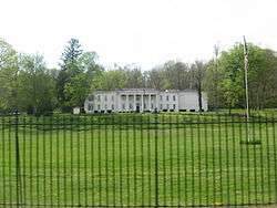
Elmhurst, an estate south of town on St. Rd. 121 built in 1831, was the home of Caleb Blood Smith, who served in Abraham Lincoln's cabinet. It also serves as the site of an annual re-enactment of the American Civil War.[12] The estate was formerly known as Conners Elm Park.
The Whitewater Valley Railroad is a 19-mile-long operating scenic railroad and museum between Connersville and Metamora.
Fayette County Historical Museum is located in the city.
The Canal House, built in 1842 as headquarters for the Whitewater Canal Company, is in the city.
In addition to the Canal House and Elmhurst, the Fayette County Courthouse and Roberts Park are listed on the National Register of Historic Places.[13][14]
Demographics

| Historical population | |||
|---|---|---|---|
| Census | Pop. | %± | |
| 1840 | 596 | — | |
| 1850 | 1,396 | 134.2% | |
| 1860 | 2,119 | 51.8% | |
| 1870 | 2,496 | 17.8% | |
| 1880 | 3,228 | 29.3% | |
| 1890 | 4,548 | 40.9% | |
| 1900 | 6,836 | 50.3% | |
| 1910 | 7,738 | 13.2% | |
| 1920 | 9,901 | 28.0% | |
| 1930 | 12,795 | 29.2% | |
| 1940 | 12,898 | 0.8% | |
| 1950 | 15,550 | 20.6% | |
| 1960 | 17,698 | 13.8% | |
| 1970 | 17,604 | −0.5% | |
| 1980 | 17,023 | −3.3% | |
| 1990 | 15,550 | −8.7% | |
| 2000 | 15,411 | −0.9% | |
| 2010 | 13,481 | −12.5% | |
| Est. 2015 | 13,010 | [15] | −3.5% |
| Source: US Census Bureau | |||
As of 2013, the population is estimated to be 13,253 people. About 55% of Fayette county's population lives in the town.
2010 census
As of the census[2] of 2010, there were 13,481 people, 5,582 households, and 3,506 families residing in the city. The population density was 1,739.5 inhabitants per square mile (671.6/km2). There were 6,450 housing units at an average density of 832.3 per square mile (321.4/km2). The racial makeup of the city was 95.7% White, 2.1% African American, 0.2% Native American, 0.3% Asian, 0.3% from other races, and 1.3% from two or more races. Hispanic or Latino of any race were 1.0% of the population.
There were 5,582 households of which 31.1% had children under the age of 18 living with them, 41.9% were married couples living together, 15.2% had a female householder with no husband present, 5.8% had a male householder with no wife present, and 37.2% were non-families. 31.6% of all households were made up of individuals and 13.8% had someone living alone who was 65 years of age or older. The average household size was 2.37 and the average family size was 2.95.
The median age in the city was 39.4 years. 24.2% of residents were under the age of 18; 8.2% were between the ages of 18 and 24; 24.3% were from 25 to 44; 25.6% were from 45 to 64; and 17.7% were 65 years of age or older. The gender makeup of the city was 47.7% male and 52.3% female.
2000 census
As of the census[4] of 2000, there were 15,411 people, 6,382 households, and 4,135 families residing in the city.
Transportation
There is no commercial air or rail (freight) service to Connersville. The Whitewater River, while mostly navigable, is not commercially viable as a means of transportation.
Freight moves into and out of Connersville by truck, principally via State Road 1 and Interstate 70 to Indianapolis, and State Road 1, U.S. Route 52 and Interstate 74 to Cincinnati. State Road 44 is mostly local and in-county traffic. SR1 and SR44 are both narrow two-lane state roads, subject to temporary closure during winter snowstorms and ice-overs. The nearest large cities are Cincinnati, OH 58 mi. to the southeast, Indianapolis 66 mi. to the west, Louisville, KY 127 mi. to the south, and Columbus, OH 135 mi. to the east.
Airport
Mettel Field is a private aviation airport located three nautical miles (6 km) north of the central business district of Connersville. There is no commercial service. It is owned by the Connersville Board of Aviation Commissioners.[16] The nearest commercial airport is Cincinnati International Airport, 62 miles to the southeast.
Railroad
Amtrak, the national passenger rail system, provides service to Connersville. Each of two trains provides service three days a week. The westbound train provides service to Indianapolis, Lafayette, and Chicago. The eastbound train provides service to Cincinnati, cities in Kentucky, and points east ending at New York City.
Bus and taxi service
There is no transit bus service to Connersville. There is a local taxi service in town.
Highways
 Indiana State Road 1 runs north-south through downtown Connersville north to beyond Fort Wayne and south to Lawrenceburg
 Indiana State Road 44 runs east-west through downtown Connersville west to Martinsville and east to the Ohio state line
 Indiana State Road 121 runs north-south from intersection with SR44 in downtown Connersville south to Metamora
 Interstate 70, 14 miles to the north via SR1 runs east-west from Indianapolis to Columbus, Ohio
 U.S. Route 40, 12 miles to the north via SR1 runs east-west from just south of Indianapolis to Richmond, IN.
Cemeteries
Connersville City Cemetery, In the middle of town, Dale Cemetery, just west of downtown, and Tullis Chapel Cemetery, 3 miles southwest of town, are the only local cemeteries. There are a few private and church cemeteries located in outlying unincorporated areas.
Hospital
Fayette Regional Hospital, located in the north central part of town, is Fayette County's only hospital. It has 173 beds and is accredited by the American Hospital Association and American Osteopathic Association.
Schools and churches
About 44% of the population is affiliated with a religious congregation. 25% are Roman Catholic, followed by United Methodist, Southern Baptist, and non-denominational Christian. In town, there are churches representing Catholic, Methodist, Baptist, Lutheran, Presbyterian, and Episcopal faiths, as well as about a dozen non-denominational Christian churches. There are also a number of Pentecostal (including Charismatic and Revival) churches and organizations.
All public schools belong to the Fayette County School Corporation. There are about 1,200 students in high school, 700 in middle school, 1,800 in public elementary schools, and 300 in parochial elementary schools (as of 2012). Public elementary schools and some parochial elementary schools include kindergarten. The Whitewater Technical Career Center is a secondary school including grades 11–12 with an enrollment of over 500; it prepares non-college-bound students for careers in the trades. There are no institutions of higher learning in Connersville. The Connersville Center offers extension courses through Indiana University East. The nearest four-year colleges are IU East and Earlham College in Richmond, Indiana, and Miami University in Oxford, Ohio, all about 25 miles (40 km) away by road.
Middle, high and trade schools
- Connersville High School
- Connersville Middle School (formerly Junior High North formerly Connersville Sr. High)
- Whitewater Career Center (formerly Connersville Area Vocational School)
Elementary schools
- Eastview
- Grandview
- Frazee
- Maplewood
- Fayette Central
- Everton
Parochial elementary schools
- St. Gabriel's (Catholic)
- Community (Christian)
- Faith (Christian)
Media
Connersville has a daily newspaper called The News Examiner in continuous publication (including predecessor papers) since 1849.
Radio station WLPK-AM 1580, owned by Rodgers Broadcasting Corporation and licensed to Connersville, operates with local programming and classic hits format. For many years Connersville simulcast AM/FM WCNB/WIFE radio. The FM which was located at 100.3 was sold to Radio One Communications for $18 million in 2006 and re-located to Cincinnati, Ohio. There is now a WIFE-FM radio station (94.3), whose tower is located in Rush County, Indiana.
Connersville High School's daily TV news program, CHS Today, was the first student-produced TV news program in the United States.[17] It began in 1970 with presenters Dennis Sullivan and Ron Stevens. At first, it was broadcast only to the school via closed-circuit TV. Later it expanded; it now airs live at 11:00 a.m. weekdays to the community and re-airs twice in the evening at 6:45 & 10:45pm via TV3 on local cable.
Notable people
- Phil Cox, 1972 Indiana Mr. Basketball, 1972 Graduate of Connersville High School, and member of 1972 Indiana High School basketball champions.[18][19]
- Howard Garns, creator of the logic game Sudoku, was born in Connersville on March 2, 1905.
- Finly H. Gray was a US Congressman elected to represent Indiana's 6th and 10th Districts in the United States House of Representatives, serving from 1911 to 1917 and 1933 to 1939. He also served as Mayor of Connersville from 1904 to 1910. Gray is buried in Dale Cemetery, located on Memorial Drive in Connersville. Gray Road, on the west side of Connersville, is named for him.
- Scott Halberstadt, television actor, was born in Connersville in 1976 and graduated from Connersville High School in 1994.
- Tom T. Hall, country singer and Grand Ole Opry member, spent time in Connersville early in his career and wrote "Thank You, Connersville" about the experience.
- Matt Howard, a three-time Academic All-American starting forward for Butler University's men's basketball team who has since played professionally for several European teams, is a 2007 graduate of Connersville High School.[20] He played in the 2010 and 2011 NCAA Championship games.[21] In February 2011, Howard was selected as the top Academic All-American in the University category (chosen from all twelve Academic All-America teams, including football).[22]
- Virginia Claypool Meredith, "Queen of American Agriculture," born in Connersville
- James N. Huston, Treasurer of the United States 1889–91, lived in Connersville most of his life, founding a local bank, Citizen's Bank.
- April McDivitt, 1999 Indiana Miss Basketball and four-time Academic All-American, is a graduate of Connersville High School. McDivitt now serves as the women's director at Champions Academy.[23]
- Carol J. Pereyra, founder of Going Bonkers Magazine, raised in Connersville, Indiana and attended middle school and high school.[24]
- Betsy Ross, former ESPN anchor, graduate of Connersville High School, now freelance broadcaster/emcee in Cincinnati, Ohio.[25]
- Caleb Blood Smith was a Congressman and the Secretary of the Interior in the Lincoln administration. He was the second occupant of the Elmhurst mansion.
- Oliver H. Smith was a Congressman and Senator. He built the Elmhurst mansion at the south edge of Connersville in 1831.
- Greg Stotelmyer, is currently the "Voice of the Colonels" for the Eastern Kentucky University's men's basketball and football teams. He also works for WTVQ news station of Richmond, KY, and has received four Emmy awards for A Year on Kentucky's Backroads (2003), He Loves to Beat People (2005), The Avon Lady (2007), and Marina's Story (2008)[26]
- Joey Sturgis, music producer, focusing mainly on metalcore bands. Clients include Attila, The Devil Wears Prada, MyChildren MyBride, Asking Alexandria, and Miss May I.
- Dan Toler, rock musician with the Allman Brothers Band and Gregg Allman Band (died 2013)
- Tony Wilson, horror author, was born in Connersville in 1977 and graduated from CHS in 1995. You can view of list of his work on his Amazon Author Page.[27]
- Robert Wise, one of Hollywood's most acclaimed directors and producers, graduated from Connersville High School in 1932. The CHS auditorium, the Robert E. Wise Center for Performing Arts, was named in his honor.[28] Wise is known for his direction of "The Sound of Music" and "West Side Story".
See also
References
- 1 2 "G001 - Geographic Identifiers - 2010 Census Summary File 1". United States Census Bureau. Retrieved 2015-07-28.
- 1 2 "American FactFinder". United States Census Bureau. Retrieved 2012-12-11.
- ↑ "Population Estimates". United States Census Bureau. Retrieved 2015-01-23.
- 1 2 "American FactFinder". United States Census Bureau. Archived from the original on 2013-09-11. Retrieved 2008-01-31.
- ↑ "US Board on Geographic Names". United States Geological Survey. 2007-10-25. Retrieved 2008-01-31.
- ↑ "Find a County". National Association of Counties. Archived from the original on 2011-05-31. Retrieved 2011-06-07.
- ↑ "US Gazetteer files: 2010, 2000, and 1990". United States Census Bureau. 2011-02-12. Retrieved 2011-04-23.
- ↑ History of Fayette County, Indiana: Containing a History of the Townships, Towns, Villages, Schools, Churches, Industries, Etc. Warner, Beers and Company. 1885. p. 96.
- ↑ Chamber of Commer history of Connersville
- ↑ Hunter, David (Oct 1, 2003). Shifra Stein's Day Trips from Cincinnati: Getaways Less Than Two Hours Away. Globe Pequot. p. 4. Retrieved 2013-04-26.
- ↑ http://fayette.k12.in.us/chs/fame/meissner.html
- ↑ http://newsexaminer.com/articles/2013/04/20/local_news/doc5171e8a8e8588171937093.txt
- ↑ National Park Service (2010-07-09). "National Register Information System". National Register of Historic Places. National Park Service.
- ↑ "National Register of Historic Places Listings". Weekly List of Actions Taken on Properties: 1/13/14 through 1/17/14. National Park Service. 2014-01-24.
- ↑ "Annual Estimates of the Resident Population for Incorporated Places: April 1, 2010 to July 1, 2015". Retrieved July 2, 2016.
- ↑ FAA Airport Master Record for CEV (Form 5010 PDF). Federal Aviation Administration. Effective May 31, 2012.
- ↑ http://fayettein.chs.schooldesk.net/Community/CHSHallofFame/tabid/11545/ctl/view/itemid/15063/Default.aspx
- ↑ http://fayettein.chs.schooldesk.net/Community/CHSHallofFame/PhilCox/tabid/11554/Default.aspx
- ↑ http://fayettein.chs.schooldesk.net/Community/CHSHallofFame/tabid/11545/ctl/view/itemid/15064/Default.aspx?returnurl=http://fayettein.chs.schooldesk.net/Community/CHSHallofFame/tabid/11545/Default.aspx
- ↑ http://fayettein.chs.schooldesk.net/Community/CHSHallofFame/tabid/11545/ctl/view/itemid/15119/Default.aspx
- ↑ http://www.butlersports.com/sports/m-baskbl/mtt/howard_matt00.html
- ↑ "Matt Howard of Butler, Austin Meier of MSOE lead Capital One Academic All-America® Men's Basketball Teams". College Sports Information Directors of America. 2011-02-22. Retrieved 2011-03-23.
- ↑ http://www.championsacademy.org/index.php?option=com_content&view=article&id=93&Itemid=59
- ↑ http://gbonkers.com
- ↑ http://gamedaypr.com/our-team/betsy-ross/
- ↑ http://www.wtvq.com/news/70-greg-stotelmyer.pdf
- ↑ http://www.amazon.com/Tony-Wilson/e/B0057ZXTQU/
- ↑ http://fayettein.chs.schooldesk.net/Community/CHSHallofFame/tabid/11545/ctl/view/itemid/15060/Default.aspx
Further reading
- A Little Journey to Connersville, Elbert Hubbard, 1917, Roycrofters, N.Y. 23pgs.
External links
- City of Connersville, Indiana website
- http://www.newsexaminer.com
- http://fayettein.schooldesk.net/
- Historic American Engineering Record (HAER) No. IN-7, "Connersville Industrial Park, Eleventh & Twenty-first Streets, Connersville, Fayette County, IN"
- https://connersvillehistory.wordpress.com/
Municipalities and communities of Fayette County, Indiana, United States | ||
|---|---|---|
| City | ||
| Town | ||
| Townships | ||
| Unincorporated communities | ||
| Footnotes | ‡This populated place also has portions in an adjacent county or counties | |