Throop Peak
| Throop Peak | |
|---|---|
 Throop Peak | |
| Highest point | |
| Elevation | 9,142 ft (2,786 m) NAVD 88[1] |
| Prominence | 618 ft (188 m) [1] |
| Listing | Hundred Peaks Section[2] |
| Coordinates | 34°21′02″N 117°47′58″W / 34.3505562°N 117.7995051°WCoordinates: 34°21′02″N 117°47′58″W / 34.3505562°N 117.7995051°W [3] |
| Geography | |
| Location | Los Angeles County, California, U.S. |
| Parent range | San Gabriel Mountains |
| Topo map | USGS Crystal Lake |
| Climbing | |
| Easiest route | Trail hike, class 1[4] |
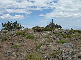
Throop Peak (/ˈtruːp/ TROOP) is a 9,142 feet (2,786 m) peak of the San Gabriel Mountains, in the San Gabriel Mountains National Monument and Angeles National Forest, in Los Angeles County, California.
The high peak provides views of both the Mojave Desert and the Los Angeles Basin all the way to the ocean. The peak was named for Amos G. Throop, founder of Caltech, formerly called Throop College.[4] The peak marks the northwestern boundary of the Sheep Mountain Wilderness.[1]
Access
A trailhead for climbing Throop Peak is located at Dawson Saddle along the Angeles Crest Highway. The route goes through a forest of Jeffrey Pine, Sugar Pine, and the high elevation Lodgepole Pine with some White Fir.[4]
Climbing Season
The most popular seasons for climbing Throop Peak are Spring and Fall because of the cooler temperatures and easy accessibility.[5]
References
- 1 2 3 "Throop Peak, California". Peakbagger.com.
- ↑ "Throop Peak". Hundred Peaks Section List. Angeles Chapter, Sierra Club. Retrieved 2010-09-24.
- ↑ "Throop Peak". Geographic Names Information System. United States Geological Survey.
- 1 2 3 "Throop Peak". United States Forest Service. Retrieved 2010-09-24.
- ↑ "Throop Peak". SummitPost.org. Retrieved 2013-02-02.
External links
- "Throop Peak". Geographic Names Information System. United States Geological Survey. Retrieved 2010-09-24.