Mount Lukens
| Mount Lukens | |
|---|---|
| Sister Elsie Peak | |
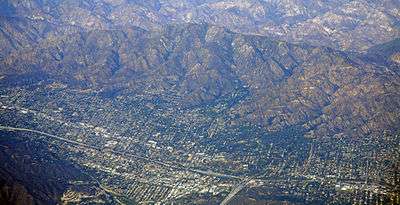 Mt. Lukens overlooking La Crescenta-Montrose | |
| Highest point | |
| Elevation | 5,075 ft (1,547 m) NAVD 88[1] |
| Prominence | 1,794 ft (547 m) [2] |
| Listing | Hundred Peaks Section[3] |
| Coordinates | 34°16′08″N 118°14′20″W / 34.269000714°N 118.238990497°WCoordinates: 34°16′08″N 118°14′20″W / 34.269000714°N 118.238990497°W [1] |
| Geography | |
 Mount Lukens  Mount Lukens Location in California | |
| Location |
Sunland-Tujunga, Los Angeles, Los Angeles County, California, U.S. |
| Parent range | San Gabriel Mountains |
| Topo map | USGS Condor Peak |
| Climbing | |
| Easiest route | Hike from Deukmejian Wilderness Park in Crescenta Highlands, Glendale[3] |
Mount Lukens is a mountain peak of the San Gabriel Mountains, located in Los Angeles County, Southern California.[4]
Geography
It is located in the Sunland-Tujunga community within the northeast corner of the city of Los Angeles, above the Crescenta Valley. The summit, at 5,075 feet (1,547 m) in elevation, is the highest point within the city limits.[5] The summit's elevation makes Los Angeles the largest city with the highest and lowest (sea level) elevation difference in the country.[6]
Because of its location, prominence, and proximity to Los Angeles, the summit is dotted with television, radio, and cellular transmission towers.[7] The mountain is also within the boundaries of the Angeles National Forest and Los Angeles County.
Name origin
The mountain was named after Theodore Lukens, a former supervisor of the Angeles National Forest and later, the mayor of Pasadena, California.[8] Previously, the mountain was known as Sister Elsie Peak. It has been said that she was a Catholic nun who died while caring for the sick during a smallpox epidemic. On the USFS map of 1925, the mountain was shown as Mount Lukens and subtitled Sister Elsie Peak.[9] The identity of Sister Elsie (also referred to as Sister Else) is not certain and the stories surrounding her have not been verified.[10]
2009 Station Fire
Mount Lukens is in an area that was impacted by the 2009 Station Fire in the San Gabriel Mountains, the largest wildfire in the history of Los Angeles County.[11]
See also
References
- 1 2 "Sister Elsie". NGS data sheet. U.S. National Geodetic Survey. Retrieved 2014-03-05.
- ↑ "Mount Lukens, California". Peakbagger.com. Retrieved 2014-03-05.
- 1 2 "Mount Lukens". Hundred Peaks Section List. Angeles Chapter, Sierra Club. Retrieved 2014-03-05.
- ↑ "Mount Lukens". Geographic Names Information System. United States Geological Survey. Retrieved 2014-03-05.
- ↑ "Mount Lukens". Local Hikes.com. Retrieved 2014-03-05.
- ↑ "Elevations and Distances in the United States". U.S. Geological Survey. Retrieved 2014-03-05. Note: Juneau, AK has a greater range.
- ↑ "Mount Lukens". Peakery.com. Retrieved 2014-03-05.
- ↑ Derby, George (1891-). The National cyclopaedia of American biography (eBook). 18. New York: J.T. White & Co. p. 282. OCLC 844617289. Check date values in:
|date=(help) - ↑ "Mount Lukens". SummitPost.org. Retrieved 2014-03-05.
- ↑ "Summit Signatures: Mount Lukens". Retrieved 2011-09-14.
- ↑ "Station fire's effects still smolder". Glendale News-Press. Retrieved 2014-03-05.