Pacific Crest Trail
| Pacific Crest Trail | |
|---|---|
|
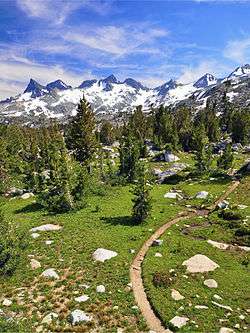
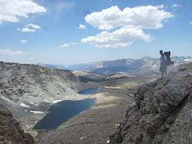
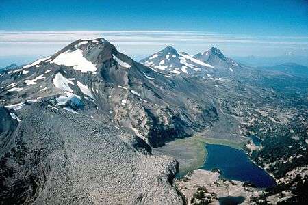
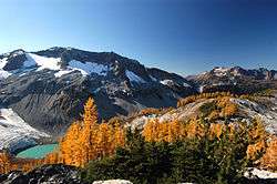
The Pacific Crest Trail in the Ansel Adams Wilderness, with a view of the Ritter Range | |
| Length | 2,659 mi (4,279 km)[1] |
| Location | California / Oregon / Washington, USA / British Columbia, Canada |
| Designation | National Scenic Trail |
| Trailheads |
Campo, California Manning Park, British Columbia |
| Use |
Hiking Horse riding |
| Elevation | |
| Elevation change | 420,880 ft (128,284 m)[2] |
| Highest point | Forester Pass, 13,153 ft (4,009 m)[3] |
| Lowest point | Cascade Locks, 140 ft (43 m)[4] |
| Hiking details | |
| Months | Late April to Late September |
| Sights |
Sierra Nevada (U.S.) Cascade Range |
| Hazards |
Severe Weather Dehydration Wildlife |
The Pacific Crest Trail (commonly abbreviated as the PCT, and officially designated as the Pacific Crest National Scenic Trail) is a long-distance hiking and equestrian trail closely aligned with the highest portion of the Sierra Nevada and Cascade mountain ranges, which lie 100 to 150 miles (160 to 240 km) east of the U.S. Pacific coast. The trail's southern terminus is on the U.S. border with Mexico, just south of Campo, California, and its northern terminus on the Canada–US border on the edge of Manning Park in British Columbia; its corridor through the U.S. is in the states of California, Oregon, and Washington.
The Pacific Crest Trail is 2,659 mi (4,279 km) long[1] and ranges in elevation from just above sea level at the Oregon–Washington border to 13,153 feet (4,009 m)[3] at Forester Pass in the Sierra Nevada. The route passes through 25 national forests and 7 national parks.[7] Its midpoint is near Chester, California (near Mt. Lassen), where the Sierra and Cascade mountain ranges meet.[8]
It was designated a National Scenic Trail in 1968, although it was not officially completed until 1993.[9] The PCT was conceived by Clinton Churchill Clarke in 1932.[10] It received official status under the National Trails System Act of 1968.
It is the westernmost and second longest component of the Triple Crown of Hiking and is part of the 6,875-mile Great Western Loop.
Route
The route is mostly through National Forest and protected wilderness. The trail avoids civilization and covers scenic and pristine mountainous terrain with few roads. It passes through the Laguna, Santa Rosa, San Jacinto, San Bernardino, San Gabriel, Liebre, Tehachapi, Sierra Nevada, and Klamath ranges in California, and the Cascade Range in California, Oregon, and Washington.
A parallel route for bicycles, the Pacific Crest Bicycle Trail (PCBT) is a 2,500-mile (4,000 km) route designed closely parallel to the PCT on roads. The PCT and PCBT cross in about 27 places along their routes.
History
The Pacific Crest Trail was first proposed by Clinton C. Clarke, as a trail running from Mexico to Canada along the crest of the mountains in California, Oregon, and Washington. The original proposal was to link the John Muir Trail, the Tahoe-Yosemite Trail (both in California), the Skyline Trail (in Oregon) and the Cascade Crest Trail (in Washington).[9]
The Pacific Crest Trail System Conference was formed by Clarke to both plan the trail and to lobby the federal government to protect the trail. The conference was founded by Clarke, the Boy Scouts, the YMCA, and Ansel Adams (amongst others). From 1935 through 1938, YMCA groups explored the 2000 miles of potential trail and planned a route, which has been closely followed by the modern PCT route.[9]
In 1968, President Lyndon B. Johnson defined the PCT and the Appalachian Trail with the National Trails System Act. The PCT was then constructed through cooperation between the federal government and volunteers organized by the Pacific Crest Trail Association. In 1993, the PCT was officially declared finished.[9]
Thru hiking
Thru hiking is a term used in referring to hikers who complete long-distance trails from end to end in a single trip. The Pacific Crest Trail, Appalachian Trail, and Continental Divide Trail were the first three long-distance trails in the U.S.. Successfully thru-hiking all of these three trails is known as the Triple Crown of Hiking.[11] Thru-hiking is a long commitment, usually taking between four and six months, that requires thorough preparation and dedication. The Pacific Crest Trail Association estimates that it takes most hikers between six and eight months to plan their trip.[12]
While most hikers travel from the Southern Terminus at the Mexico–US border northward to Manning Park, British Columbia, some hikers prefer a southbound route. In a normal weather year, northbound hikes are most practical due to snow and temperature considerations. If snowpack in the Sierra Nevada is high in early June and low in the Northern Cascades, some hikers may choose to 'flip-flop.' Flip-flopping can take many forms but often describes a process whereby a hiker begins at one end (on the PCT, usually the southern end) of the trail and then, at some point, like reaching the Sierra, 'flips' to the end of the trail at the Canada–US border and hikes southbound to complete the trail. However, it is not currently possible to legally enter the United States from Canada by using the Pacific Crest Trail.[13]
Hikers also have to determine their resupply points. Resupply points are towns or post offices where hikers replenish food and other supplies such as cooking fuel. Hikers can ship packages to themselves at the U.S. Post Offices along the trail, resupply at general and grocery stores along the trail, or any combination of the two.[14] The final major logistical step is to create an approximate schedule for completion. Thru hikers have to make sure they complete enough miles every day to reach the opposite end of the trail before weather conditions make sections impassable. For northbound thru-hikers, deep snow pack in the Sierra Nevada can prevent an early start. The timing is a balance between not getting to the Sierra too soon nor the Northern Cascades too late. Most hikers cover about 20 miles (32 km) per day.[12]
In order to reduce their hiking time and thereby increase their chances of completing the trail, many hikers try to substantially reduce their pack weight. Since the creation of the Pacific Crest Trail there has been a large movement by hikers to get away from large heavy packs with a lot of gear. There are three general classifications for hikers: Traditional, Lightweight, and Ultralight.[15] Over the past few years the number of traditional hikers has dropped considerably.
Notable hikers
Before the PCT was planned, Martin Papendick was the first known person to hike across three states of the PCT in 1952.[16] After being one of the first to finish the Appalachian trail in 1951, Papendick hiked between July 4 and December 1, 1952, from British Columbia to the Mexico–US border over the crests of the mountains along the Pacific Coast, a feat he reported in a periodical under the title "Pacific Crest Trails".[17]
On October 16, 1970, Eric Ryback, an 18-year-old student, completed the first PCT thru-hike. His personal congratulations came by telegram from no less than Edward P. Cliff, Chief of the U.S. Forest Service.[18] Ryback is credited, recognized, and has been honored by the Pacific Crest Trail Associated as the official first thru-hiker of the entire trail.[19] Ryback completed the Appalachian Trail in 1969 (as a 16-year-old); the Pacific Crest Trail in 1970; and a route approximating today’s Continental Divide Trail in 1972.[20] Ryback's 1971 book The High Adventure of Eric Ryback: Canada to Mexico on Foot focused public attention on the PCT. Ryback carried an 80-pound pack on his 1970 thru-hike. He had only five resupply packages on the entire trip and was loaded with 40 pounds of food at the start of each leg. He often ran out of food and foraged or went hungry.[19] Ryback also helped the Forest Service lay out future plans for the PCT.[21]
However, Ryback's claim is disputed. When the guidebook publisher, Wilderness Press, stated in print that Ryback had used motor transport in places along the PCT, Ryback sued for $3 million but withdrew the suit after Wilderness Press revealed statements from the people who claim to have picked up the young hiker along highways parallel to the 2,600-mile trail.[22] Ryback is in Smithsonian's top 9 list of people Cheating Their Way to Fame though it notes that The claims that Ryback “cheated” are still doubted by some.[23]
The first person to hike the PCT from south to north was Richard Watson, who completed the trail on September 1, 1972.[16] Watson was often credited as the first PCT thru-hiker, because Papendick was generally unknown and Ryback may have accepted rides.[16] The first woman to complete the PCT was Mary Carstens, who finished the journey later in 1972, accompanied by Jeff Smukler.[16]
The first person to thru-hike the entire PCT both ways in a single continuous round-trip was Scott Williamson, who completed the "yo-yo" circuit on his fourth attempt in November 2004. Williamson traveled a total of 5,300 miles (8,530 km) in 197 days, covering an average of 35 to 40 miles (56 to 64 km) per day when not in snow – an overall average of 27 miles (43 km) per day – wearing an extremely ultra-lightweight pack, which "without food, weighed about 8.5 pounds (3.9 kg)".[24] Williamson then went on to complete a second round trip on November 28, 2006, cutting two weeks off his 2004 time.[25]
The youngest person to hike the trail is Christian Thomas Geiger, who at the age of 6 completed the 2686 mile trail with his parents Andrea Rego and Dion Pagonis. [26] Christian, also known by his trail name Buddy Backpacker, is also the youngest person to hike the Appalachian Trail [27] [28]
Other notable young hikers include Sierra Burror and Reed Gjonnes. Sierra Burror, who completed a continuous thru-hike of the trail in 2012 at the age of 9, is the youngest girl to thru-hike the trail. She completed her hike with her mother, Heather Burror.[29][30][31][32] Reed Gjonnes, who thru-hiked the trail in 2011 at age 11, went on to complete the Triple Crown of Hiking, becoming the youngest person ever to do so.[33]
An autobiographical account of a woman hiking a portion of the PCT alone in 1995 at age 26 was written by Cheryl Strayed. Her memoir Wild: From Lost to Found on the Pacific Crest Trail was published in 2012 and reached #1 on the New York Times Best Sellers list.[34] Her hike is the subject of the 2014 film Wild, starring Reese Witherspoon.
The oldest person to thru-hike the trail is not known.[35]
On August 7, 2013, Heather "Anish" Anderson of Bellingham, Washington, set the current unsupported speed record. She completed the entire PCT in 60 days, 17 hours, 12 minutes,[36] beating the previous record by almost 4 days.[37]
In 2014, Olive McGloin (from Ireland) became the first woman to thru-hike the PCT both ways in a single continuous round-trip.[38]
On August 10, 2014, Joseph McConaughy of Shoreline, Washington, and a former Boston College middle distance runner, set a new supported speed record and the overall fastest time for the PCT. The distance was covered in 53 days, 6 hours, and 37 minutes.[39][40][41] This overcame the previous record of 59 days, 8 hours, 14 minutes,[37][42][43][44] set by Josh Garret on August 8, 2013, by more than 6 days. Joe was supported by a team of three hikers, Jordan Hamm (a former Boston College distance runner), Michael Dillon, and Jack Murphy.
McConaughly's record was broken on August 14, 2016 by Karel Sabbe, a 27-year-old dentist from Ghent, Belgium. He covered the distance in a total time of 52 days, 8 hours, and 25 minutes, shaving almost a day off the previous record.[45] Sabbe was supported by his friend Joren Biebuyck. There has been some debate about the validity of Sabbe's attempt, because of multiple deviations from the trail caused by bushfires.[46]
Deaths
The first two reported deaths were in November 1995, when thru-hikers Jane and Flicka Rodman were killed during a detour down California State Route 138 in Southern California, when they were struck by a motorist who lost control of his vehicle. They were less than 400 miles from their goal of reaching the Mexico–US border.[47][48]
In May 2005, John Donovan died just five days shy of his 60th birthday after becoming lost on San Jacinto Peak in an unseasonal snowstorm. His body was not recovered until more than a year later. The cause of death is unknown, but hypothermia is suspected.[49]
Wendell Ray Echols (“No Way Ray”) of Mariposa, California died on May 15, 2006, near Deep Creek Hot Springs in a remote part of the San Bernardino National Forest. Ray was hiking with his wife, Alice Tulloc, when he lost his footing and fell approximately 200 feet to his death. Alice was hiking roughly 20 yards behind him when he went around a corner and disappeared. Another group of hikers heard Alice’s cries for help and were able to use a satellite phone to call for assistance. Ray was pronounced dead at the scene.[50]
At the age of 19, Timothy Evan Nodal died on April 24, 2014, of heat stroke near Lake Morena. Timothy began to feel sick and phoned his stepfather for help. When firefighters arrived, they were going over his symptoms when he suddenly went into arrest. Emergency personnel were unable to revive him. There was no evidence of dehydration or alcohol or substance abuse, according to the coroner's report.[51]
Equestrian use
Don and June Mulford made the first verifiable equestrian Thru-Ride of the PCT in 1959.[52][53][54] In that year the Pacific Crest Trail stretched a poorly marked 2,400 miles from Mexico to Canada. More concept than footpath, the trail was an oft-broken, high-ridge track disappearing regularly from map and terrain. On April 19, 1959, on an empty scrub sage plain seven miles east of Tijuana, with four horses, Don and June Mulford began their journey north to the Washington–Canada border. The Mulfords went to Hollywood for three months immediately after the ride and were featured on network television. June's old press book yields a half-dozen TV-Guide pages, and she recalls, "Art Linkletter was such a nice man. We appeared on his 'House Party' show and he had coffee with us afterward." "High Road to Danger," a syndicated TV show, made an episode on their ride. Even after they had returned home to the Northwest, there was continued TV coverage. A January 1961 TV Guide records their appearance on Portland's KOIN Red Dunning Show. The Mulfords even made a 90-minute movie and showed it around 12 western states for 10 years.
The Murray family – Barry, Bernice, Barry Jr. and Bennette – completed the trek on horseback on October 7, 1970.[55]
Future
In 2008, an agreement for realignment through Tejon Ranch was reached.[56]
Portland, Oregon's 40 Mile Loop proposes to extend the Springwater Corridor hiking and bicycling spur trail to connect the Pacific Crest Trail[57] with the proposed Cazadero Trail.[58]
Notable locations
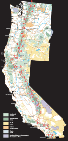
The following notable locations are found along or adjacent to the route of the Pacific Crest Trail. They are listed from south to north to correspond with the itinerary typically followed by thru-hikers to take advantage of the best seasonal weather conditions. The numbers in parentheses correspond to the numbers on the PCT overview map above.
California
- Campo, California, near the trail's southern terminus at the Mexico–United States border
- Anza-Borrego Desert State Park (41)
- Cleveland National Forest (40)
- Mount San Jacinto State Park
- Big Bear Lake
- Cajon Pass
- Angeles National Forest (35)
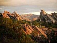
- Vasquez Rocks
- Agua Dulce
- Walker Pass
- Owens Peak Wilderness (34)
- South Sierra Wilderness (34)
- Golden Trout Wilderness (34)
- Kings Canyon National Park (33)
- Forester Pass, highest point on the trail
- John Muir Wilderness (31)
- Ansel Adams Wilderness (30)
- Yosemite National Park (29)
- Sonora Pass, Ebbetts Pass, Carson Pass
- Desolation Wilderness
- Lassen National Forest (22)
- McArthur-Burney Falls Memorial State Park (21)
- Shasta-Trinity National Forest (19)
- Klamath Mountains
Oregon

- Cascade–Siskiyou National Monument (17)
- Rogue River National Forest (16) and Winema National Forest (14)
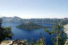
- Crater Lake National Park (15)
- Umpqua National Forest (13)
- Willamette National Forest (11) and Deschutes National Forest (12)
- Diamond Peak Wilderness
- Waldo Lake
- Three Sisters Wilderness
- Dee Wright Observatory and McKenzie Pass (water supply 250 m west of the observatory)
- Mount Washington Wilderness
- Mount Jefferson Wilderness
- Mount Hood National Forest (9)
- Columbia River Gorge National Scenic Area (8)
- Mark O. Hatfield Wilderness (formerly the Columbia Wilderness)
- Cascade Locks, Oregon, lowest point on the trail
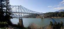
- Bridge of the Gods (links Oregon and Washington, crossing the Columbia River)
Washington
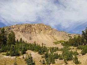
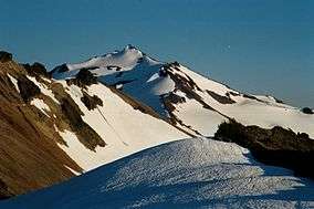
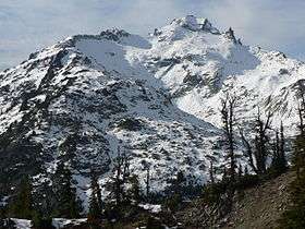 Mount Daniel in the Alpine Lakes Wilderness |
||
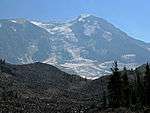 Adams Glacier viewed from the PCT on Mount Adams |
||
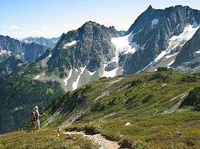 Cascade Pass in the North Cascades National Park |
 |
- Gifford Pinchot National Forest (7)
- Mount Rainier National Park (6)
- Mount Baker-Snoqualmie National Forest (5)
- Snoqualmie Pass
- Stevens Pass
- Lake Chelan National Recreation Area
- Stehekin, Washington, last town along the trail, 10 miles (16 km) from PCT by NPS bus
- North Cascades National Park (2)
- Okanogan National Forest (3)
- Pacific Northwest National Scenic Trail
- Boundary Monument 78, at the Canada–United States border
British Columbia, Canada
- E.C. Manning Provincial Park, the northern terminus of the trail (1)
Location coordinates
| Point | Coordinates (links to map & photo sources) |
Notes |
|---|---|---|
| United States – Mexico border | 32°35′23″N 116°28′07″W / 32.5898°N 116.4685°W | |
| Forester Pass | 36°41′39″N 118°22′19″W / 36.6941°N 118.3720°W | highest point |
| Midpoint | 40°12′48″N 121°21′17″W / 40.2132°N 121.3546°W | |
| Oregon – California border | 42°00′14″N 122°54′36″W / 42.0038°N 122.9100°W | |
| Columbia River | 45°39′45″N 121°53′58″W / 45.6624°N 121.8994°W | lowest point |
| Canada – United States border | 49°00′00″N 120°47′55″W / 49.0000°N 120.7987°W |
Coordinates: 40°12′48″N 121°21′17″W / 40.2132°N 121.3546°W
See also
- Other Triple Crown trails
- Connected National Scenic Trail
- Connected National Historic Trails
- California Trail
- Juan Bautista de Anza National Historic Trail
- Lewis and Clark National Historic Trail
- Old Spanish Trail
- Oregon Trail
- Pony Express National Historic Trail
- Connected U.S. long-distance trails
- High Sierra Trail
- John Muir Trail
- Mark O. Hatfield Memorial Trail
- Oregon Skyline Trail
- Tahoe-Yosemite Trail
- Tahoe Rim Trail
- Timberline Trail
- Long-distance routes
References
- 1 2 Halfmile's Pacific Crest Trail Notes - Ashland, OR to Manning Park, BC (PDF), retrieved 2016-03-05
- ↑ Parks, Scott (2011-04-06). "Postholer.com Pacific Crest Trail Data Book". Retrieved 2011-04-18.
- 1 2 Sources disagree on Forester Pass's elevation. The Forest Service claims 13,180 feet (4,017 m)[5] while the USGS says 13,153 feet (4,009 m),[6] but topographic maps showing 36°41′39″N 118°22′19″W / 36.6941°N 118.3720°W indicate a little less than 13,123 feet (4,000 m).
- ↑ "Pacific Crest National Scenic Trail". USFS. Archived from the original on 2010-01-16.
- ↑ "Pacific Crest Trail – Central California Online Map and Guide". USFS. 2005-04-26. Archived from the original on 2006-05-25. Retrieved 2006-09-23.
- ↑ "Forester Pass". Geographic Names Information System. United States Geological Survey.
- ↑ "Pacific Crest National Scenic Trail." Parks Directory of the United States. 2004 ed.
- ↑ Backpacker Magazine. "Pacific Crest Trail: CA Section 31". Trimble Outdoors.
- 1 2 3 4 "History of the Pacific Crest Trail". Archived from the original on 2010-01-22. Retrieved 2010-03-28.
- ↑ Gally, Sid. "The Pacific Crest Trail had its roots in Pasadena". Pasadena Star News.
- ↑ Berger, Karen (2001). Hiking the Triple Crown: How to Hike America's Longest Trails : Appalachian Trail, Pacific Crest Trail, Continental Divide Trail. Seattle: Mountaineers Press. ISBN 0-89886-760-6.
- 1 2 "FAQs". Pacific Crest Trail Association. Archived from the original on 2011-12-25. Retrieved 2006-12-19.
- ↑ Wilson, Kimberly (2010-07-02). "Mind the border: Feds warn Pacific Crest Trail hikers crossing from Canada to U.S.". The Oregonian.
- ↑ "Pacific Crest Trail Resupply Points". PlanYourHike.com. Retrieved 2010-03-01.
- ↑ Jardine, Ray (2000). Beyond Backpacking: Ray Jardine's Guide to Lightweight Hiking. LaPine, OR: AventureLore. ISBN 0-9632359-3-1.
- 1 2 3 4 Schifrin, Ben; Schaffer, Jeffrey P; Jenkins, Ruby Johnson (2003). The Pacific Crest Trail: Southern California. Wilderness Press. p. 5. ISBN 0-89997-316-7.
- ↑ Papendick, Martin. "Pacific Crest Trails". Appalachia. Appalachian Mountain Club, 1953. XXVIII: 374–376.
- ↑ "Ryback Returns" (PDF). Pcta.org. Retrieved 13 January 2015.
- 1 2 "Fun Facts". Pacific Crest Trail Association. Archived from the original on 2012-08-28. Retrieved 13 January 2015.
- ↑ "Medals for Miles" (PDF). Pcta.org. Retrieved 13 January 2015.
- ↑ "Muir Trail Story". Mchalepacks.com. Retrieved 13 January 2015.
- ↑ Dropping the suit is not necessarily a confession of cheating but could have been motivated by the difficulty of litigating the case, unavailability of witnesses, and the misplacement of journals, photos, and other evidence after many years.
- ↑ Alastair Bland (April 17, 2013). "Cheating Their Way to Fame". smithsonian.com. Retrieved October 10, 2014.
- ↑ "Hiker Completes First Round-Trip of Pacific Crest Trail". Outside Magazine. November 18, 2004. Archived from the original on 2004-12-04. Retrieved 2009-09-14.
- ↑ "A solo accomplishment is appreciated by many". San Diego Union-Tribune. 2006-12-02. Retrieved 2006-12-02.
- ↑ http://www.buddybackpacker.com/buddy-backpacker-pacific-crest-trail-thru-hiker/
- ↑ http://appalachiantrials.com/buddy-backpacker-5-year-old-thru-hiker/
- ↑ http://www.backpacker.com/special-features/kindergarten-can-wait/
- ↑ "Nine-year-old Monkey completes the PCT". Pacific Crest Trail Association. Retrieved 30 January 2016.
- ↑ "An Interview with "Monkey"". Retrieved 30 January 2016.
- ↑ Burror, Heather (March 29 & 30, 2014) "Adventures on the Pacific Crest Trail" Inyo Register p. 15.
- ↑ See also Heather and Sierra's PCT Thru Hike Journal
- ↑ Zach Urness, (Salem, Ore.) Statesman Journal (27 October 2013). "Ore. girl, 13, youngest to claim hiking 'Triple Crown'". Usatoday.com. Retrieved 13 January 2015.
- ↑ Taylor, Ihsan. "Best Sellers - The New York Times". Nytimes.com. Retrieved 2012-03-06.
- ↑ "Interview with John Craig". RadioNZ. In this interview, John was stated as being the oldest person to walk the trail but this was as a result of miscommunication. In 2010, White Beard walked the trail at 70 but he may not be the oldest.
- ↑ Doug Williams, Records set on Pacific Crest Trail, at ESPN Enduracne Sports, September 3, 2013
- 1 2 "Pacific Crest Trail (CA, OR, WA)". Fastest Known Time. Retrieved 13 January 2015.
- ↑ "A walk on the wild side: meet the first woman to YoYo the Pacific Crest Trail". Irish Times.
- ↑ "Seattle Runner Smashes Speed Record For Full Length of Pacific Crest Trail". Northwest Public Radio.
- ↑ "55 miles a day: Blistering pace for hiker seeking Pacific Crest record". The Seattle Times.
- ↑ "Run For Colin". Runforcolin.com. Retrieved 13 January 2015.
- ↑ "PCT speed record is shattered twice". Pacific Crest Trail Association. Retrieved 13 January 2015.
- ↑ "Vegan Hiker Sets New Record On Pacific Crest Trail". Oregon Public Broadcasting. Retrieved 13 January 2015.
- ↑ "Man, woman set records on Pacific Crest Trail". Seattle Times. Retrieved 13 January 2015.
- ↑ http://appalachiantrials.com/karel-sabbe-claims-new-supported-pct-speed-record/
- ↑ https://trailrunnermag.com/component/content/article/2257-karel-sabbe-pacific-crest-trail-fkt-debate
- ↑ "Jane and Flicka Rodman", Pacific Crest Trail Association', Retrieved 2015-05-07.
- ↑ "Sierra hikers remembered in trek by family, friends". The Las Vegas Sun. Aug 18, 1997. Retrieved 8 May 2015.
- ↑ Donahue, Bill. "Lost & Found". Backpacker.com. Retrieved 8 May 2015.
- ↑ "Ray Echols". Pacific Crest Trail Association. Retrieved 8 May 2015.
- ↑ Stickney, R. (Jul 28, 2014). "Death of Teenager Along Pacific Crest Trail Ruled an Accident". NBC San Diego. Retrieved 8 May 2015.
- ↑ Meadows, Mel (1959-09-06). Seattle Post Intelligencer. Missing or empty
|title=(help) - ↑ Mann, Barney (2009-09-25). Portland Oregonian. Missing or empty
|title=(help) - ↑ Mann, Barney (December 2009). PCTA Communicator. Missing or empty
|title=(help) - ↑ Life Magazine, September 3, 1971
- ↑ "PCT alignment through Tejon Ranch a big step closer - Pacific Crest Trail Association". 2014-05-07. Retrieved 2016-07-26.
- ↑ "40 Mile Loop map". 40-Mile Loop Land Trust. Archived from the original (PDF) on 2009-04-27. Retrieved 2008-07-10.
- ↑ "Cazadero Trail". Metro (Oregon). Retrieved August 16, 2013.
External links
| Wikivoyage has a travel guide for Pacific Crest Trail. |
| Wikimedia Commons has media related to Pacific Crest Trail. |
- Pacific Crest Trail Association – Non-profit that maintains and promotes the trail, and provides advice to hikers
- Postholer.Com – An extensive source of PCT information, journals, Google trail maps, printed maps, data book and more.
- PlanYourHike.Com – A website dedicated to helping hikers plan their Pacific Crest Trail thru hikes.
- Trailjournals.com – PCT Photos & 1,000+ Pacific Crest Trail Journals
- Pacific Crest Trail: A Ride to Remember Documentary produced by Oregon Public Broadcasting
- Islands In The Sky: Tales From The Pacific Crest Trail – KCET Covers the PCT
- BLM, Pacific Crest National Scenic Trail – BLM's Summary of the PCT