| [2] |
Landmark name |
Image |
Date designated[3] |
Location |
County |
Description |
|---|
| 1 |
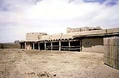
Bent's Old Fort |
|
000000001960-12-19-0000December 19, 1960
(#66000254) |
La Junta
38°02′34″N 103°25′51″W / 38.042886°N 103.430786°W / 38.042886; -103.430786 (Bent's Old Fort) |
Otero |
Adobe fort built in 1833 to trade with Plains Indians and trappers, on Santa Fe Trail
|
| 2 |
Central City/Black Hawk Historic District |
|
000000001961-07-04-0000July 4, 1961
(#66000246) |
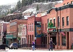
Central City and Black Hawk
39°48′04″N 105°30′27″W / 39.801111°N 105.5075°W / 39.801111; -105.5075 (Central City/Black Hawk Historic District) |
Gilpin |
Former gold mining camps in the Front Range of the Rocky Mountains, once known as the 'Richest Square Mile on Earth
|
| 3 |
Colorado Chautauqua |
|
000000002006-02-10-0000February 10, 2006
(#78000830) |
Boulder
39°59′52″N 105°16′50″W / 39.997778°N 105.280556°W / 39.997778; -105.280556 (Colorado Chautauqua) |
Boulder |
This 1898 Chautauqua is the only one West of the Mississippi, one of only four continuously operating since its inception, and the only one open year round.
|
| 4 |
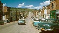
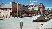
Cripple Creek Historic District |
|
000000001961-07-04-0000July 4, 1961
(#66000939) |
Cripple Creek
38°45′07″N 105°10′31″W / 38.751944°N 105.175278°W / 38.751944; -105.175278 (Cripple Creek Historic District) |
Teller |
The gold mining town of Cripple Creek and the surrounding hills
|
| 5 |
Denver & Rio Grande Railroad San Juan Extension(Cumbres & Toltec Scenic Railroad) |
|
000000002012-10-16-0000October 16, 2012
(#73000462) |
Antonito, CO and Chama, NM
37°00′22″N 106°17′44″W / 37.006048°N 106.295485°W / 37.006048; -106.295485 (Denver & Rio Grande Railroad San Juan Extension) |
Archuleta, CO, Conejos, CO, and Rio Arriba, NM |
Longest & most complete representation of late nineteenth- and early twentieth-century railroading.
|
| 6 |
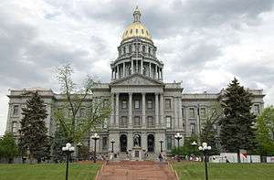
Denver Civic Center |
|
000000002012-10-16-0000October 16, 2012
(#12001017) |
Denver
39°44′21″N 104°59′12″W / 39.739237°N 104.986753°W / 39.739237; -104.986753 (Denver Civic Center) |
Denver |
City Beautiful-era civic center.
|
| 7 |
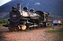
Durango-Silverton Narrow-Gauge Railroad |
|
000000001961-07-04-0000July 4, 1961
(#66000247) |
Durango to Silverton
37°17′51″N 107°42′39″W / 37.2975°N 107.710833°W / 37.2975; -107.710833 (Durango-Silverton Narrow-Gauge Railroad) |
San Juan and La Plata |
Narrow gauge mining railroad which has continued to serve as a tourist line between Durango and Silverton
|
| 8 |
Georgetown-Silver Plume Historic District |
|
000000001966-11-13-0000November 13, 1966
(#66000243) |
Georgetown and Silver Plume
39°41′55″N 105°42′48″W / 39.698611°N 105.713333°W / 39.698611; -105.713333 (Georgetown-Silver Plume Historic District) |
Clear Creek |
Historic district which includes the silver mining towns of Georgetown and Silver Plume as well as the 1884 railway engineering marvel which connects them, the Georgetown Loop Railroad.
|
| 9 |
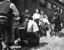
Granada Relocation Center |
|
000000002006-02-10-0000February 10, 2006
(#94000425) |
Granada
38°02′58″N 102°19′43″W / 38.049444°N 102.328611°W / 38.049444; -102.328611 (Granada Relocation Center) |
Prowers |
World War II Japanese American internment center
|
| 10 |
Leadville Historic District |
|
000000001961-07-04-0000July 4, 1961
(#66000248) |
Leadville
39°14′39″N 106°13′42″W / 39.244167°N 106.228333°W / 39.244167; -106.228333 (Leadville Historic District) |
Lake |
Historic Leadville, Colorado mining district and village area
|
| 11 |
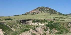
Lindenmeier Site |
|
000000001961-01-20-0000January 20, 1961
(#66000249) |
Norfolk
40°58′48″N 105°03′44″W / 40.979898°N 105.062256°W / 40.979898; -105.062256 (Lindenmeier Site) |
Larimer |
The only extensive Folsom culture campsite yet found with artifacts dating from approximately 11200 BCE to 3000 BCE.
|
| 12 |
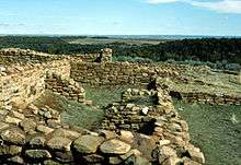
Lowry Ruin |
|
000000001964-07-19-0000July 19, 1964
(#66000253) |
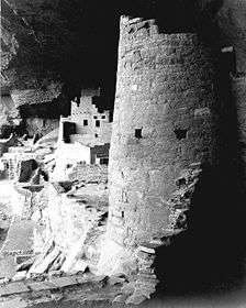
Pleasant View
37°35′04″N 108°55′11″W / 37.584531°N 108.919647°W / 37.584531; -108.919647 (Lowry Ruin) |
Montezuma |
Ancient Pueblo Peoples archaeological site from 1060 with a very large kiva
|
| 13 |
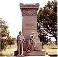
Ludlow Tent Colony Site |
|
000000002009-01-16-0000January 16, 2009
(#85001328) |
Ludlow
37°20′00″N 104°35′00″W / 37.333333°N 104.583333°W / 37.333333; -104.583333 (Ludlow Tent Colony Site) |
Las Animas |
Site of 1914 miners' strike that culminated in Ludlow Massacre
|
| 14 |
Mesa Verde Administrative District |
|
000000001987-05-29-0000May 29, 1987
(#87001410) |
Mesa Verde National Park
37°10′53″N 108°29′26″W / 37.181264°N 108.490654°W / 37.181264; -108.490654 (Mesa Verde Administrative District) |
Montezuma |
First buildings built by the National Park Service with intent to reflect cultural traditions in the park area, built in 1921
|
| 15 |
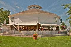
Philadelphia Toboggan Company Carousel No. 6 |
|
000000001987-02-27-0000February 27, 1987
(#78000861) |
Burlington
39°18′26″N 102°16′13″W / 39.307102°N 102.270324°W / 39.307102; -102.270324 (Philadelphia Toboggan Company Carousel No. 6) |
Kit Carson |
Carousel built for Elitch Gardens in 1905. In 1928 it moved to Kit Carson County fairgrounds where it remains open today. It is the only antique carousel in America retaining its original paint on both the scenery panels and the animals, and it is the only surviving Philadelphia Toboggan Company menagerie carousel.
|
| 16 |
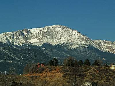
Pikes Peak |
|
000000001961-07-04-0000July 4, 1961
(#66000245) |
Colorado Springs
38°50′26″N 105°02′39″W / 38.840556°N 105.044167°W / 38.840556; -105.044167 (Pikes Peak) |
El Paso |
Pike's Peak (everything above 14,000 feet (4,300 m) elevation). This mountain was inspiration for "America the Beautiful" as well as the motto "Pike's Peak or Bust"
|
| 17 |
Pike's Stockade |
|
000000001961-07-04-0000July 4, 1961
(#66000244) |
Sanford
37°17′30″N 105°48′36″W / 37.291792°N 105.809944°W / 37.291792; -105.809944 (Pike's Stockade) |
Conejos |
Explorer Zebulon Pike set up a fort here.
|
| 18 |
Raton Pass |
|
000000001960-12-19-0000December 19, 1960
(#66000474) |
Trinidad, CO and Raton, NM
36°59′25″N 104°29′17″W / 36.9903°N 104.488°W / 36.9903; -104.488 (Raton Pass) |
Las Animas, CO and Colfax, NM |
Mountain pass between New Mexico and Colorado
|
| 19 |
Red Rocks Park and Mount Morrison Civilian Conservation Corps Camp |
|
000000002015-08-04-0000August 4, 2015
(#90000725) |
Morrison, CO
39°39′41″N 105°12′29″W / 39.661389°N 105.208056°W / 39.661389; -105.208056 (Red Rocks Park and Mount Morrison Civilian Conservation Corps Camp) |
Jefferson |
Denver Mountain Park and camp where workers stayed while building the park's amphitheater.
|
| 20 |
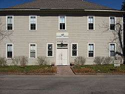
Rocky Mountain National Park Administration Building |
|
000000002001-01-03-0000January 3, 2001
(#01000069) |
Estes Park
40°21′58″N 105°33′39″W / 40.366111°N 105.560833°W / 40.366111; -105.560833 (Rocky Mountain National Park Administration Building) |
Larimer |
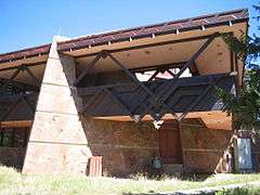
Also known as the Beaver Meadows Visitor Center, it was designed by Taliesin Associated Architects, their first major work after Frank Lloyd Wright had died. It demonstrated modern architecture could be successful inside the National Parks and was the last significant project in Mission 66.
|
| 21 |
Shenandoah-Dives (Mayflower) Mill |
|
000000002000-02-16-0000February 16, 2000
(#00000262) |
Silverton
37°49′44″N 107°37′42″W / 37.828972°N 107.628207°W / 37.828972; -107.628207 (Shenandoah-Dives (Mayflower) Mill) |
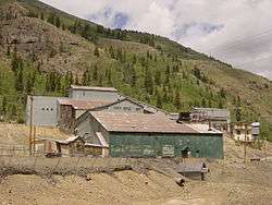
San Juan |
Only surviving example of a selective flotation mill in Colorado.
|
| 22 |
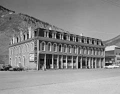
Silverton Historic District |
|
000000001961-07-04-0000July 4, 1961
(#66000255) |
Silverton
37°48′45″N 107°39′47″W / 37.812545°N 107.662994°W / 37.812545; -107.662994 (Silverton Historic District) |
San Juan |
Former silver mining town, home of the Shenandoah-Dives (Mayflower) Mill and one end of the Durango-Silverton Narrow-Gauge Railroad
|
| 23 |
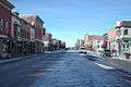
Telluride Historic District |
|
000000001961-07-04-0000July 4, 1961
(#66000256) |
Telluride
37°56′14″N 107°48′29″W / 37.937222°N 107.808056°W / 37.937222; -107.808056 (Telluride Historic District) |
San Miguel |
Former gold mining boomtown, it is now an artistic retreat and a ski resort town
|
| 24 |
Trujillo Homestead |
|
000000002012-02-01-0000February 1, 2012
(#03001544) |
Mosca
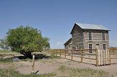
37°44′00″N 105°44′09″W / 37.7333°N 105.7358°W / 37.7333; -105.7358 (Trujillo Homestead) |
Alamosa |
Early ranch settlement (1880s) in the San Luis Valley, with a surviving period ranch house; located on a Nature Conservancy property near Great Sand Dunes National Park.
|
| 25 |
United States Air Force Academy, Cadet Area |
|
000000002004-04-01-0000April 1, 2004
(#04000484) |
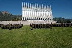
Colorado Springs
39°00′30″N 104°53′26″W / 39.008333°N 104.890417°W / 39.008333; -104.890417 (United States Air Force Academy, Cadet Area) |
El Paso |
Bold use of Modern architecture at the United States Air Force Academy, especially with the Cadet Chapel |