Lamar, Colorado
| Lamar, Colorado | |
|---|---|
| Home Rule Municipality | |
|
Main Street facing north in downtown (2007) | |
 Location within Prowers County and Colorado | |
| Coordinates: 38°05′10″N 102°37′10″W / 38.08611°N 102.61944°WCoordinates: 38°05′10″N 102°37′10″W / 38.08611°N 102.61944°W | |
| Country |
|
| State |
|
| County | Prowers County Seat[1] |
| Incorporated | December 5, 1886[2] |
| Government | |
| • Type | Home Rule Municipality[1] |
| • Mayor | Roger Stagner[3] |
| Area | |
| • Total | 4.2 sq mi (11 km2) |
| • Land | 4.2 sq mi (11 km2) |
| • Water | 0 sq mi (0 km2) |
| Elevation[4] | 3,625 ft (1,105 m) |
| Population (2010) | |
| • Total | 7,804 |
| • Estimate (2014)[5] | 7,608 |
| • Density | 1,900/sq mi (710/km2) |
| Time zone | Mountain (MST) (UTC-7) |
| • Summer (DST) | MDT (UTC-6) |
| ZIP code[6] | 81052 |
| Area code(s) | 719 |
| FIPS code | 08-43110 |
| GNIS feature ID | 0203835 |
| Website | City Website |

Lamar is a Home Rule Municipality that is the county seat and the most populous municipality of Prowers County, Colorado, United States.[7] The city population was 7804 at the 2010 United States Census. The city was named after Lucius Quintus Cincinnatus Lamar II[8] during the period that he was Secretary of the Interior in the futile hope that the then town would be named as the land office.
History

The northern site of the Pierre Auger Observatory of ultra-high energy cosmic rays is planned to be built near Lamar.[9]
Geography and climate
Lamar is located at 38°5′10″N 102°37′10″W / 38.08611°N 102.61944°W. According to the United States Census Bureau, the city has a total area of 4.2 square miles (11 km2), all land. Lamar is east of Pueblo, on the Arkansas River in southeastern Colorado.
Lamar is antipodal, or globally opposite, to Ile Amsterdam, an island in the southern Indian Ocean, making Lamar one of only three locations in the United States that is opposite another landmass on earth.
| Climate data for Lamar, Colorado Averages (1981–2010) Records (2000-2016) | |||||||||||||
|---|---|---|---|---|---|---|---|---|---|---|---|---|---|
| Month | Jan | Feb | Mar | Apr | May | Jun | Jul | Aug | Sep | Oct | Nov | Dec | Year |
| Record high °F (°C) | 74 (23) |
87 (31) |
89 (32) |
94 (34) |
103 (39) |
111 (44) |
109 (43) |
109 (43) |
104 (40) |
95 (35) |
86 (30) |
73 (23) |
111 (44) |
| Average high °F (°C) | 45.1 (7.3) |
49.2 (9.6) |
59.5 (15.3) |
68.8 (20.4) |
77.9 (25.5) |
87.5 (30.8) |
93.0 (33.9) |
90.5 (32.5) |
83.0 (28.3) |
70.3 (21.3) |
56.4 (13.6) |
45.2 (7.3) |
68.9 (20.5) |
| Average low °F (°C) | 14.5 (−9.7) |
18.0 (−7.8) |
26.7 (−2.9) |
36.3 (2.4) |
47.4 (8.6) |
57.5 (14.2) |
62.5 (16.9) |
61.1 (16.2) |
51.2 (10.7) |
36.6 (2.6) |
24.1 (−4.4) |
14.9 (−9.5) |
37.6 (3.1) |
| Record low °F (°C) | −15 (−26) |
−17 (−27) |
−5 (−21) |
14 (−10) |
27 (−3) |
38 (3) |
49 (9) |
49 (9) |
34 (1) |
19 (−7) |
−5 (−21) |
−15 (−26) |
−15 (−26) |
| Average precipitation inches (mm) | 0.44 (11.2) |
0.48 (12.2) |
0.87 (22.1) |
1.32 (33.5) |
2.12 (53.8) |
2.39 (60.7) |
2.36 (59.9) |
2.51 (63.8) |
1.35 (34.3) |
1.01 (25.7) |
0.52 (13.2) |
0.47 (11.9) |
15.84 (402.3) |
| Average snowfall inches (cm) | 6.5 (16.5) |
5.0 (12.7) |
5.0 (12.7) |
1.8 (4.6) |
0.0 (0) |
0.0 (0) |
0.0 (0) |
0.0 (0) |
0.1 (0.3) |
1.4 (3.6) |
3.3 (8.4) |
6.1 (15.5) |
29.2 (74.2) |
| Source: NOAA[10] | |||||||||||||
Demographics
| Historical population | |||
|---|---|---|---|
| Census | Pop. | %± | |
| 1890 | 566 | — | |
| 1900 | 987 | 74.4% | |
| 1910 | 2,977 | 201.6% | |
| 1920 | 2,512 | −15.6% | |
| 1930 | 4,233 | 68.5% | |
| 1940 | 4,445 | 5.0% | |
| 1950 | 6,829 | 53.6% | |
| 1960 | 7,369 | 7.9% | |
| 1970 | 7,797 | 5.8% | |
| 1980 | 7,713 | −1.1% | |
| 1990 | 8,343 | 8.2% | |
| 2000 | 8,869 | 6.3% | |
| 2010 | 7,804 | −12.0% | |
| Est. 2015 | 7,555 | [11] | −3.2% |
As of the census[13] of 2000, there were 8,869 people, 3,324 households, and 2,247 families residing in the city. The population density was 2,095.8 people per square mile (809.5/km²). There were 3,656 housing units at an average density of 863.9/sq mi (333.7/km²). The racial makeup of the city was 76.24% White, 0.38% African American, 1.48% Native American, 0.47% Asian, 0.05% Pacific Islander, 18.81% from other races, and 2.57% from two or more races. Hispanic or Latino of any race were 36.54% of the population.
There were 3,324 households out of which 36.0% had children living with them, 49.2% were married couples living together, 13.3% had a female householder with no husband present, and 32.4% were non-families. 28.2% of all households were made up of individuals and 12.4% had someone living alone who was 65 years of age or older. The average household size was 2.59 and the average family size was 3.18.
In the city the population was spread out with 29.1% under the age of 18, 12.1% from 18 to 24, 26.1% from 25 to 44, 19.5% from 45 to 64, and 13.1% who were 65 years of age or older. The median age was 31 years. For every 100 females there were 98.6 males. For every 100 females age 18 and over, there were 95.8 males.
The median income for a household in the city was $28,660, and the median income for a family was $32,560. Males had a median income of $24,145 versus $20,133 for females. The per capita income for the city was $13,900. About 14.4% of families and 19.7% of the population were below the poverty line, including 29.5% of those under age 18 and 12.2% of those age 65 or over.
Education
Public schools
Lamar is part of School District RE-2.[14][15]
Higher education
Lamar is home to Lamar Community College, founded in 1937.[16]
Infrastructure
Transportation
Rail
Lamar receives intercity passenger rail service via Amtrak's Southwest Chief, which runs between Chicago and Los Angeles, stopping twice each day, once in each direction. See Lamar (Amtrak station).
Bus
Bus service is provided daily eastward towards Wichita, Kansas and westward towards Pueblo, Colorado by BeeLine Express (subcontractor of Greyhound Lines).[17][18]
Highways
-
 US 50 is an east-west highway running from Interstate 80 near West Sacramento, California to an intersection with Maryland State Highway 528 at Ocean City, Maryland. It is also the main route to Pueblo and Las Animas.
 -
 Prowers County Road 196 (state has abandoned highway) is a 11.4-mile (18.3 km) stretch that connects around Lamar to Wiley.
 -

 US 287/385 are two concurrent highways that run south through Lamar. They connect Lamar to Springfield. US 287 runs from Texas State Highway 87 in Port Arthur, Texas to US 89 at Choteau, Montana. US 385 runs from Big Bend National Park in Texas to US 85 in Deadwood, SD.
Notable people
Notable individuals who were born in and/or have lived in Lamar include:
- Gordon L. Allott (1907-1989), U.S. Senator from Colorado[19]
- Marvin Ash (1914-1974), jazz pianist[20]
- Doug Brocail (1967- ), baseball pitcher[21]
- Ken Curtis (1916-1991), actor, singer[22]
- Scott Elarton (1976- ), baseball pitcher[23]
- Curt Gentry (1931-2014), journalist, non-fiction author[24]
- Gerald Gregg (1907-1985), illustrator, book cover artist[25]
- Wayne R. Grisham (1923-2011), U.S. Representative from California[26]
- Floyd D. Hall (1916-2012), pilot, airline executive[27]
- Kenneth Kester (1936- ), Colorado state legislator[28]
- Wesley Tuttle (1917-2003), singer-songwriter, guitarist[29]
- Sandy Vance (1947- ), baseball pitcher[30]
See also
- Outline of Colorado
- State of Colorado
- Lamar Amtrak train station
- Madonna of the Trail monument
- National Old Trails Road
- Santa Fe National Historic Trail
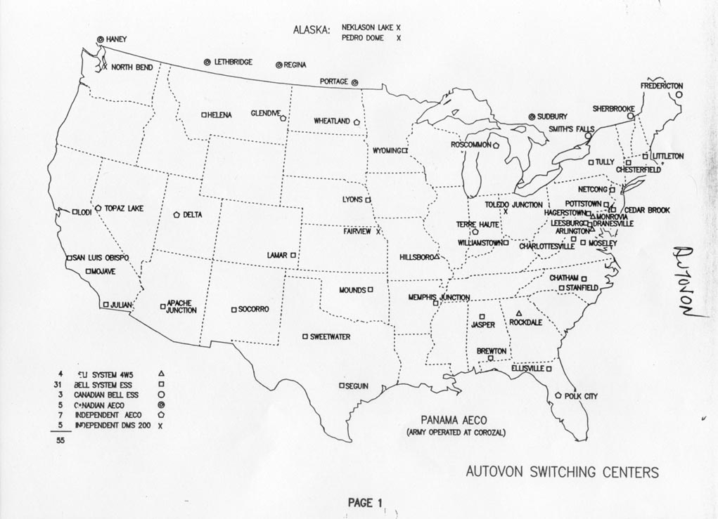
- Autovon[31]
References
- 1 2 "Active Colorado Municipalities". State of Colorado, Department of Local Affairs. Retrieved 2007-09-01.
- ↑ "Colorado Municipal Incorporations". State of Colorado, Department of Personnel & Administration, Colorado State Archives. 2004-12-01. Retrieved 2007-09-02.
- ↑ "2009 - 2011 City Elected Officials". City of Lamar. Retrieved 2011-11-25.
- ↑ "US Board on Geographic Names". United States Geological Survey. 2007-10-25. Retrieved 2008-01-31.
- ↑ "Annual Estimates of the Resident Population: April 1, 2010 to July 1, 2014". United States Census Bureau. Retrieved 2015-06-28.
- ↑ "ZIP Code Lookup" (JavaScript/HTML). United States Postal Service. Retrieved November 13, 2007.
- ↑ "Find a County". National Association of Counties. Retrieved 2011-06-07.
- ↑ Gannett, Henry (1905). The Origin of Certain Place Names in the United States. Government Printing Office. p. 180.
- ↑ Pierre Auger Observatory - Northern Auger Site
- ↑ "Observed Weather Reports". National Oceanic and Atmospheric Administration. Retrieved February 19, 2016.
- ↑ "Annual Estimates of the Resident Population for Incorporated Places: April 1, 2010 to July 1, 2015". Retrieved July 2, 2016.
- ↑ "Census of Population and Housing". Census.gov. Retrieved June 4, 2015.
- ↑ "American FactFinder". United States Census Bureau. Retrieved 2008-01-31.
- ↑ Lamar School District
- ↑ "Lamar School District RE-2". Retrieved 10 January 2014.
- ↑ "About LCC". Retrieved 10 January 2014.
- ↑ BeeLine Express
- ↑ Greyhound Lines
- ↑ "Allott, Gordon Llewellyn, (1907-1989)". Biographical Directory of the United States Congress. U.S. Congress. Retrieved 2016-06-21.
- ↑ Edwards, Bill. "Marvin E. Ashbaugh". RagPiano.com. Retrieved 2016-06-21.
- ↑ "Doug Brocail". Baseball-Reference.com. Retrieved 2016-06-21.
- ↑ "Ken Curtis (I)". IMDb. Retrieved 2016-06-21.
- ↑ "Scott Elarton". Baseball-Reference.com. Retrieved 2016-06-21.
- ↑ Nolte, Carl (2014-07-19). "Curt Gentry dies: best-selling writer of Manson, Hoover books". San Francisco Chronicle. Retrieved 2016-06-21.
- ↑ "Summary Bibliography: Gerald Gregg". Internet Speculative Fiction Database. Retrieved 2016-06-21.
- ↑ "Grisham, Wayne Richard, (1923-2011)". Biographical Directory of the United States Congress. U.S. Congress. Retrieved 2016-06-21.
- ↑ Hevesi, Dennis (2012-05-03). "Floyd D. Hall, Head of Eastern Airlines, Dies at 96". The New York Times. Retrieved 2016-06-21.
- ↑ "Kenneth Kester's Biography". Vote Smart. Retrieved 2016-06-21.
- ↑ "Wesley Tuttle [Obituary]". The Independent. 2003-10-15. Archived from the original on July 30, 2011. Retrieved 2016-06-21.
- ↑ "Sandy Vance". Baseball-Reference.com. Retrieved 2016-06-21.
- ↑ Former Autovon Switching Centers.
Further reading
- The National Old Trails Road To Southern California, Part 1 (LA to KC); Automobile Club Of Southern California; 64 pages; 1916. (Download 6.8MB PDF eBook)
- Thomas Lamar Coughlin "Those Southern Lamars" ISBN 0-7388-2410-0
External links
- City of Lamar
- Lamar Ledger, local newspaper
- Lamar City Map, CDOT
- Santa Fe Trail Research Site
- Lamar School District RE-2
Municipalities and communities of Prowers County, Colorado, United States | ||
|---|---|---|
| City | 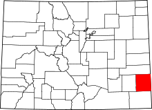 | |
| Towns | ||
| Unincorporated communities | ||