Lowry Pueblo
|
Lowry Ruin | |
|
Lowry Pueblo | |
  | |
| Location | Montezuma County, Colorado, USA |
|---|---|
| Nearest city | Pleasant View, Colorado |
| Coordinates | 37°35′4.31″N 108°55′10.73″W / 37.5845306°N 108.9196472°WCoordinates: 37°35′4.31″N 108°55′10.73″W / 37.5845306°N 108.9196472°W |
| NRHP Reference # | 66000253 |
| Significant dates | |
| Added to NRHP | October 15, 1966[1] |
| Designated NHL | July 19, 1964[2] |

The Lowry Pueblo is an Ancestral Puebloan archaeological site located in Canyons of the Ancients National Monument near Pleasant View, Colorado, United States. The pueblo was constructed around 1060 AD atop abandoned pithouses from an earlier period of occupation. It was occupied by 40 to 100 people at a time for 165 years.[3] The structure was built up to about 40 rooms and featured multiple kivas. The architecture of Lowry Pueblo was influenced by the settlement at Chaco Canyon, approximately 100 miles to the south.[3]
The inhabitants were farmers who also hunted small game, made elaborately decorated pottery, and wove cotton obtained by trade. Its last occupation occurred in the early 13th century.
The pueblo was named for the early area homesteader George Lowry. Lowry Pueblo was excavated during summer field seasons from 1930 to 1936 by Paul Sidney Martin of the Field Museum of Natural History in Chicago. The site was declared a National Historic Landmark on 1964-07-19.[2][4]
Lowry Pueblo was incorporated as part of the Canyons of the Ancients National Monument on 2000-06-09, and is now managed by the Bureau of Land Management.
 Lowry Pueblo
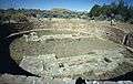 Great Kiva in Lowry Pueblo
See also
References
- ↑ National Park Service (2007-01-23). "National Register Information System". National Register of Historic Places. National Park Service.
- 1 2 "Lowry Ruin". National Historic Landmark summary listing. National Park Service. Retrieved October 16, 2007.
- 1 2 Bureau of Land Management
- ↑ Albert H. Schroeder (September 24, 1962) National Survey of Historic Sites and Buildings: Lowry Pueblo (includes maps and diagrams of site), National Park Service and Accompanying 2 photos, from the Field expedition.
External links
- Lowry Pueblo at United States Bureau of Land Management website
- Lowry Ruin at Field Museum of Natural History website
37°35′04″N 108°55′11″W / 37.584531°N 108.919648°W

| Topics | |
|---|---|
| Lists by states |
|
| Lists by insular areas | |
| Lists by associated states | |
| Other areas | |
| |