Gunnison Gorge Wilderness
| Gunnison Gorge Wilderness | |
|---|---|
|
IUCN category Ib (wilderness area) | |
 | |
 | |
| Location | Montrose / Delta counties, Colorado, USA |
| Nearest city | Montrose, CO |
| Coordinates | 37°40′00″N 107°50′00″W / 37.66667°N 107.83333°W[1]Coordinates: 37°40′00″N 107°50′00″W / 37.66667°N 107.83333°W[2] |
| Area | 17,784 acres (71.97 km2) |
| Established | 1999 |
| Governing body | Bureau of Land Management |
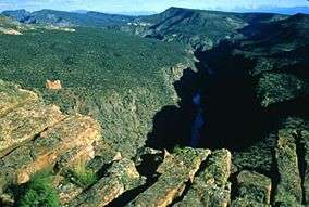
The Gunnison Gorge Wilderness is a U.S. Wilderness Area located immediately northwest of the Black Canyon of the Gunnison National Park. The 17,784-acre (71.97 km2) wilderness area established in 1999 includes 14 miles (23 km) of the Gunnison River inside the Gunnison Gorge National Conservation Area.[3][4]
References
- ↑ "Gunnison Gorge Wilderness". Geographic Names Information System. United States Geological Survey. Retrieved August 10, 2012.
- ↑ "Gunnison Gorge Wilderness". Geographic Names Information System. United States Geological Survey. Retrieved August 10, 2012.
- ↑ "Gunnison Gorge Wilderness". Bureau of Land Management. Retrieved August 10, 2012.
- ↑ "Gunnison Gorge Wilderness". Wilderness.net. Retrieved August 10, 2012.
This article is issued from Wikipedia - version of the 11/19/2016. The text is available under the Creative Commons Attribution/Share Alike but additional terms may apply for the media files.