National Register of Historic Places listings in the Federated States of Micronesia

This is a list of the buildings, sites, districts, and objects listed on the National Register of Historic Places in the Federated States of Micronesia. There are currently 26 listed sites located in all 4 states of the Federated States of Micronesia.
- This National Park Service list is complete through NPS recent listings posted December 16, 2016.[1]
Numbers of listings
The following are approximate tallies of current listings in the Federated States on the National Register of Historic Places. These counts are based on entries in the National Register Information Database as of April 24, 2008[2] and new weekly listings posted since then on the National Register of Historic Places web site.[3] There are frequent additions to the listings and occasional delistings and the counts here are not official. Also, the counts in this table exclude boundary increase and decrease listings which modify the area covered by an existing property or district and which carry a separate National Register reference number.
| State | # of Sites | |
|---|---|---|
| 1 | Kosrae | 3 |
| 2 | Pohnpei | 10 |
| 3 | Chuuk | 8 |
| 4 | Yap | 5 |
| Total: | 26 | |
Kosrae
| [4] | Name on the Register | Image | Date listed[5] | Location | Municipality | Description |
|---|---|---|---|---|---|---|
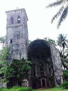
| 1 | Leluh Ruins |  |
(#83004524) |
Address Restricted |
Lelu | |
| 2 | Safonfok | Upload image | (#02000004) |
Address Restricted |
Walung | |
| 3 | Likinlulem | Upload image | (#04000277) |
Walung 5°17′32″N 162°54′40″E / 5.292361°N 162.911111°E |
Walung |
Pohnpei
Chuuk

Yap
| [4] | Name on the Register | Image | Date listed[5] | Location | Municipality | Description |
|---|---|---|---|---|---|---|
| 1 | Rull Men's Meetinghouse |  |
(#76002214) |
Rull 9°30′19″N 138°07′21″E / 9.5053°N 138.1226°E |
Rull | |
| 2 | O'Keefe's Island | Upload image | (#76002216) |
Near Colonia 9°31′38″N 138°07′54″E / 9.527222°N 138.131667°E |
Weloy | |
| 3 | Spanish Fort | Upload image | (#76002215) |
Colonia 9°30′50″N 138°07′36″E / 9.513889°N 138.126528°E |
Weloy | |
| 4 | Dinay Village | Upload image | (#04000276) |
Dinay 9°30′37″N 138°06′12″E / 9.510139°N 138.103333°E |
Rull | |
| 5 | Bechiel Village Historic District | Upload image | (#83004522) |
Address Restricted |
Maap |
See also
| Wikimedia Commons has media related to National Register of Historic Places in the Federated States of Micronesia. |
References
- ↑ "National Register of Historic Places: Weekly List Actions". National Park Service, United States Department of the Interior. Retrieved on December 16, 2016.
- ↑ National Park Service (2008-04-24). "National Register Information System". National Register of Historic Places. National Park Service.
- ↑ "National Register of Historic Places: Weekly List Actions". National Park Service. Retrieved January 16, 2009.
- 1 2 3 4 Numbers represent an ordering by significant words. Various colorings, defined here, differentiate National Historic Landmarks and historic districts from other NRHP buildings, structures, sites or objects.
- 1 2 3 4 The eight-digit number below each date is the number assigned to each location in the National Register Information System database, which can be viewed by clicking the number.
| Topics | |
|---|---|
| Lists by states |
|
| Lists by insular areas | |
| Lists by associated states | |
| Other areas | |
| |