Shenandoah-Dives Mill
|
Shenandoah-Dives (Mayflower) Mill | |
  | |
| Location | San Juan County, Colorado |
|---|---|
| Nearest city | Silverton, Colorado |
| Coordinates | 37°49′44.5″N 107°37′39″W / 37.829028°N 107.62750°WCoordinates: 37°49′44.5″N 107°37′39″W / 37.829028°N 107.62750°W |
| Built | 1928 |
| Architect | Arthur J. Weinig, Metallurgy |
| NRHP Reference # | 00000262 |
| Significant dates | |
| Added to NRHP | February 16, 2000[1] |
| Designated NHL | February 16, 2000[2] |
The Shenandoah-Dives Mill or Mayflower Mill is an intact and functional but inactive historic ore mill two miles east of Silverton, Colorado, United States. The mill was built in 1929 to recover gold, silver, lead, zinc, and copper from ore mined at the Mayflower mine and brought to the mill by an aerial tramway.
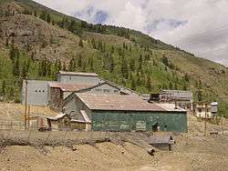
The mill recovered metals from the ore by gravity separation and by selective flotation.[3] The sulfide ore minerals were concentrated by froth flotation, an innovative method in the early twentieth century that allowed processing of ores that would previously have been too difficult for feasibility. The original mill equipment is still in working order. It is the only intact and functional mill of its kind in Colorado.[3]
It was declared a National Historic Landmark in 2000.[2][4] The mill is owned by the Silverton Historic Society, which staffs an information and gift shop at the mill under the name Mayflower Mill. The mill is open for self-guided tours in the summer months.
References
- ↑ National Park Service (2007-01-23). "National Register Information System". National Register of Historic Places. National Park Service.
- 1 2 "Shenandoah-Dives (Mayflower) Mill". National Historic Landmark summary listing. National Park Service. Retrieved 2007-10-09.
- 1 2 Colorado History
- ↑ Dawn Bunyak (August 25, 1999) National Historic Landmark Nomination: Shenandoah-Dives Mill / Mayflower Mill, National Park Service and Accompanying 32 photos, exterior and interior, from 1932, 1960, and 1995.
External links
- Silverton Historical Society - operates mill tours
- Silverton Historic Society description of Mayflower Mill
- 9news description of mill
- Silverton magazine description of Mine and Mill

| Topics | |
|---|---|
| Lists by states |
|
| Lists by insular areas | |
| Lists by associated states | |
| Other areas | |
| |
37°49′44″N 107°37′42″W / 37.828972°N 107.628207°W