Rawah Wilderness
| Rawah Wilderness | |
|---|---|
|
IUCN category Ib (wilderness area) | |
|
Rawah Wilderness | |
 | |
| Location | Larimer County, Colorado, USA |
| Nearest city | Fort Collins, CO |
| Coordinates | 40°46′10″N 105°59′22″W / 40.76944°N 105.98944°WCoordinates: 40°46′10″N 105°59′22″W / 40.76944°N 105.98944°W[1] |
| Area | 76,394 acres (309.16 km2) |
| Established | 1964 |
| Governing body | U.S. Forest Service |
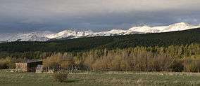
The Rawah Wilderness is administered by the USDA Forest Service. It is located on the Canyon Lakes Ranger District of the Roosevelt National Forest in Colorado, near the Wyoming border, and also in the Routt National Forest to its south. It encompasses 76,394 acres (309.16 km2) and includes 25 named lakes ranging in size from five to 39 acres (20,000 to 160,000 m2). There are 85 miles (137 km) of trails in the area and elevation ranges from 8,400 feet (2,600 m) to 13,000 feet (4,000 m). Much of the area is traversed by the Medicine Bow Mountains and the Rawah Range for which it is named.[2][3][4]
References
- ↑ "Rawah Wilderness". Geographic Names Information System. United States Geological Survey. Retrieved August 12, 2012.
- ↑ "Rawah Wilderness". Wilderness.net. Retrieved August 12, 2012.
- ↑ "Rawah Wilderness". U.S. Forest Service. Retrieved August 12, 2012.
- ↑ "Rawah Wilderness Area". Colorado Wilderness. Retrieved August 12, 2012.
This article is issued from Wikipedia - version of the 11/19/2016. The text is available under the Creative Commons Attribution/Share Alike but additional terms may apply for the media files.