Castlewood Canyon State Park
| Castlewood Canyon State Park | |
|---|---|
|
IUCN category V (protected landscape/seascape) | |
|
Remnants of Castlewood Dam | |
 Colorado | |
| Location | Douglas County, Colorado, USA |
| Nearest city | Castle Rock, CO |
| Coordinates | 39°19′47″N 104°44′19″W / 39.32972°N 104.73861°WCoordinates: 39°19′47″N 104°44′19″W / 39.32972°N 104.73861°W |
| Area | 2,621 acres (10.61 km2) |
| Established | 1964 |
| Governing body | Colorado Department of Natural Resources |
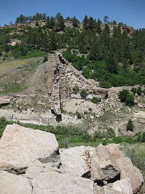
Castlewood Canyon State Park is a Colorado state park near Franktown, Colorado. The park retains a unique part of Colorado's history, the remains of Castlewood Canyon Dam. Visitors can still see the remnants and damage from that dam which burst in 1933. The event sent a 15-foot (5 m) wave of water all the way to downtown Denver resulting in a flood. Also contained within the park is the historic Cherry Creek Bridge.
Recreation
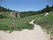
This park hosts a multitude of hiking/running trails, handicapped access trails and rock climbing opportunities, as well as a nature preservation area on the eastern side that is home to wildlife and interesting geological features.[1] Located within the northernmost extension of the Black Forest, Castle Wood Canyon encompasses 2,136 acres (9 km2) with elevations ranging from 6,200 to 6,600 feet (2,010 m). Many urban dwellers come for the picnic opportunity away from the city (group picnic facilities can be reserved), others visit the park because of the unusual geology, particularly the caprock features.
Wildlife, ecology, and geography
Among the many species living in the park are coyote, cottontail rabbit, red fox, black bear, prairie rattlesnake, mountain lion, meadow jumping mouse, turkey vulture, golden eagle, prairie falcon, virile crayfish, Woodhouse's toad and the northern leopard frog.
Ecosystem Zones in the park are grasslands, shrublands, riparian, foothills-conifer, and caprock.
Castlewood Canyon is on the edge of the Palmer Divide, a geologically upraised area that results in more moisture falling than is normal in eastern Colorado, watering the Black Forest.
See also
References
- ↑ Brachfeld, Aaron. "The other Castlewood Canyon State Park - a phototour". the Meadowlark Herald (August 2015). the Meadowlark Herald. Retrieved 08/03/2015. Check date values in:
|access-date=(help)
- "Castlewood Canyon State Park". Colorado State Parks.
- "Plants at Castlewood Canyon State Park". Colorado State Parks.