Spanish Peaks Wilderness
| Spanish Peaks Wilderness | |
|---|---|
|
IUCN category Ib (wilderness area) | |
|
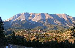
West Spanish Peak in the Spanish Peaks Wilderness | |
 | |
| Location | Huerfano / Las Animas counties, Colorado, United States |
| Nearest city | Walsenburg |
| Coordinates | 37°22′57″N 104°58′43″W / 37.38250°N 104.97861°WCoordinates: 37°22′57″N 104°58′43″W / 37.38250°N 104.97861°W[1] |
| Area | 19,226 acres (77.80 km2) |
| Established | January 1, 2000 |
| Governing body | U.S. Forest Service |
The Spanish Peaks Wilderness is a 19,226 acres (77.80 km2) wilderness area in Huerfano County and Las Animas County, Colorado, United States, located 20 miles (32 km) southwest of Walsenburg. All of the wilderness area is located within San Isabel National Forest, which is managed by the U.S. Forest Service.[2][3]
Geography
The Spanish Peaks (Spanish: Las Cumbres Españolas) are prominent landmarks along the eastern front of the southern Rockies. Their snow-capped summits of the East Spanish Peak and the West Spanish Peak, rise 7,000 feet (2,100 m) above the arid plains, made the "Double Mountain" an easily recognizable reference point to travelers of all cultures. The West Spanish Peak with an elevation of 13,623 feet (4,152 m), overtops the East Spanish Peak which only has an elevation of 12,708 feet (3,873 m). However, this difference is not readily discernible from a distance.
History
The Peaks have traditional and religious significance to American Indian tribes including the Apache, Comanche, and Ute. Summer thunderstorms, which often form near the summits, were evidence the rain gods worked their magic on the peaks. The common Indian name appears in at least three different spellings in various accounts, reflecting different renditions of oral expression. These are "Wahatoya", Huajatolla" or Guajatoyah", roughly interpreted as "breasts of the earth".
Geology
The Spanish Peaks are geologically distinct from the faulted and uplifted mountains of the Sangre de Cristo range to the west. To the geologist the Spanish Peaks are prime examples of "stocks" which are defined as large masses of igneous (molten) rock which intruded layers of sedimentary rock and were later exposed by erosion. When mapped by geologists the Peaks were found to be masses of granite, granodiorite, and syenodiorite.
Among the most unusual features of the Spanish Peaks are the great dikes which radiate out from the mountains like spokes of a wheel. These walls of rock are often spectacular. They are easily visible from the highway north of the peaks (and west of Walsenburg), and pictures of them have been used as type examples in more than one introductory geology textbook. Several can be easily seen up close on back dirt roads, and one (Apishapa Arch) on the south side of the peaks can actually be driven through.
References
- ↑ "Spanish Peaks Wilderness". Geographic Names Information System. United States Geological Survey. Retrieved August 12, 2012.
- ↑ "Spanish Peaks Wilderness". Wilderness.net. Retrieved August 12, 2012.
- ↑ "Spanish Peaks Wilderness". U.S. Forest Service. Retrieved August 12, 2012.