Sand Creek Massacre National Historic Site
| Sand Creek Massacre National Historic Site | |
|---|---|
|
IUCN category V (protected landscape/seascape) | |
|
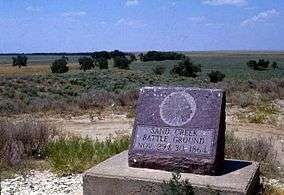
The site, July 1985 | |
  | |
| Location | Kiowa County, Colorado, United States |
| Nearest city | Eads, CO |
| Coordinates | 38°32′27″N 102°31′43″W / 38.54083°N 102.52861°WCoordinates: 38°32′27″N 102°31′43″W / 38.54083°N 102.52861°W |
| Area | 12,583 acres (5,092 ha)[1] |
| Established | April 27, 2007 |
| Visitors | 1,229,590 (in 2011)[2] |
| Governing body | National Park Service |
| Website | Sand Creek Massacre National Historic Site |
Sand Creek Massacre National Historic Site is a National Historic Site in Kiowa County, Colorado, near Eads and Chivington in Kiowa County commemorating the Sand Creek Massacre. The site is about 170 miles (270 km) southeast of Denver and about 125 miles (200 km) east of Pueblo. A few basic park facilities have been opened at this site.

In 1999, archaeological teams from the National Park Service, Dept. of the Interior BLM, Colorado Historical Society and accompanied by Native American observers, made a major archaeological discovery of remains of the massacre site. Large numbers of period bullets, camp equipment, and other items convinced the NPS that they had found the correct site. Subsequent transfers of ownership from the Dawson family, former owners of the property have left the title of the site to the Cheyenne and Arapaho tribes with management to be undertaken by NPS. The National Park Service offers scheduled Ranger-led programs without charge during hours of operation, from 9 am – 4 pm, April 1 – December 1, or by advance appointment in the winter season.
The Historical Site was authorized by Public Law 106-465 on November 7, 2000, in order to "recognize the national significance of the massacre in American history, and its ongoing significance to the Cheyenne and Arapaho people and the descendants of the massacre victims." The law authorized establishment of the site once the National Park Service acquired sufficient land from willing sellers to preserve, commemorate, and interpret the massacre. The site near the junction of County Road 54 and County Road "W" was listed on the National Register of Historic Places on September 28, 2001. On August 2, 2005, President George W. Bush gave final approval for the site. On April 23, 2007 it was announced that site would become America's 391st official park unit[3] with an effective date of April 27, 2007.[4] The dedication ceremony was held on April 28, 2007.[5]
Currently the Site encompasses 12,583 acres (5,092 ha) of which 2,385 acres (965 ha) are federally owned.[1] By 2004 the federal government acquired 920 acres (3.7 km2) from private land owners. On September 9, 2006 the Cheyenne and Arapaho Tribes of Oklahoma conveyed to the United States title to 1,465 acres (6 km2) to be held in trust for the National Historic Site.[4]
References
- 1 2 "Listing of acreage as of December 31, 2011". Land Resource Division, National Park Service. Retrieved 2012-03-19.
- ↑ "NPS Annual Recreation Visits Report". National Park Service. Retrieved 2012-03-19.
- ↑ U.S. Dept. of Interior. "Secretary Kempthorne Creates Sand Creek Massacre National Historic Site". Retrieved May 2, 2007.
- 1 2 Dirk Kempthorne (Federal Register Volume 72, Number 81, pp. 21048-21049). "Notice of Establishment of the Sand Creek Massacre National Historic Site". Retrieved May 2, 2007.
- ↑ National Park Service. "Sand Creek Massacre NHS Dedication, Schedule of Events" (PDF). Retrieved May 2, 2007.
External links
![]() Media related to Sand Creek massacre site at Wikimedia Commons
Media related to Sand Creek massacre site at Wikimedia Commons
- Sand Creek Massacre National Historic Site – National Park Service
- Sand Creek Tours – tours of the massacre site on the Bowen cattle ranch
- The Conservation Fund – Sand Creek Massacre National Historic Site

| Overview | |||||||||||||||
|---|---|---|---|---|---|---|---|---|---|---|---|---|---|---|---|
| Contemporary peoples native to Colorado |
| ||||||||||||||
| Prehistoric cultures in Colorado |
| ||||||||||||||
| Related articles | |||||||||||||||
| Topics | |
|---|---|
| Lists by states |
|
| Lists by insular areas | |
| Lists by associated states | |
| Other areas | |
| |