List of National Historic Landmarks in Alaska
The National Historic Landmarks in Alaska represent Alaska's history from its Russian heritage to its statehood. There are 49 National Historic Landmarks (NHLs) in the state.[1] The United States National Historic Landmark program is operated under the auspices of the National Park Service, and recognizes structures, districts, objects, and similar resources according to a list of criteria of national significance.[2] Major themes include Alaska's ancient cultures, Russian heritage, and role in World War II, but other stories are represented as well. In addition, two sites in Alaska were designated National Historic Landmarks, but the designation was later withdrawn. These sites appear in italics in another table further below.
The National Historic Landmark Program is administered by the National Park Service, a branch of the Department of the Interior. The National Park Service determines which properties meet NHL criteria and makes nomination recommendations after an owner notification process.[2] The Secretary of the Interior reviews nominations and, based on a set of predetermined criteria, makes a decision on NHL designation or a determination of eligibility for designation.[3] Both public and privately owned properties can be designated as NHLs. This designation provides indirect, partial protection of the historic integrity of the properties via tax incentives, grants, monitoring of threats, and other means.[2] Owners may object to the nomination of the property as a NHL. When this is the case the Secretary of the Interior can only designate a site as eligible for designation.[3]
NHLs in Alaska
The table below lists all 49 of the National Historic Landmark sites, along with added detail and description.
| [4] | Landmark name | Image | Date designated[5] | Location | County | Description |
|---|---|---|---|---|---|---|
| 1 | Adak Army Base and Adak Naval Operating Base | 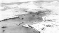 |
(#87000841) |
Adak Station 51°52′19″N 176°38′10″W / 51.872°N 176.636°W |
Aleutians West | Established in 1942 as part of World War II, this military base was the launching pad for the American attack on the Japanese-held Aleutian Islands of Kiska and Attu. |
| 2 | Alaska Native Brotherhood Hall | .jpg) |
(#72000192) |
Sitka 57°02′57″N 135°20′22″W / 57.0492°N 135.3394°W |
Sitka | This 1914 meeting hall and headquarters building served the original chapter of Alaska Native Brotherhood, founded by Tlingits in the early 1900s to fight discrimination and represent interests of natives. |
| 3 | Amalik Bay Archeological District | .jpg) |
(#05000460) |
King Salmon 58°05′19″N 154°32′06″W / 58.0886°N 154.535°W |
Lake and Peninsula | An archeological site located in Lake and Peninsula Borough |
| 4 | American Flag Raising Site | _by_Postels.jpg) |
(#66000162) |
Sitka 57°02′48″N 135°20′02″W / 57.0468°N 135.3338°W |
Sitka | In 1867, site of Russian flag lowering and American flag raising marking the transfer of Alaska to the U.S.; in 1959, after Alaska admitted as 49th state, site of first official raising of 49-star U.S. flag; also called Castle Hill. |
| 5 | Anangula Site | .jpg) |
(#78000512) |
Nikolski 53°00′02″N 168°54′40″W / 53.00056°N 168.91111°W |
Aleutians West | Site of earliest signs of human occupation in the Aleutian Islands. |
| 6 | Attu Battlefield and U.S. Army and Navy Airfields on Attu | 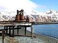 |
(#85002729) |
Attu Island 52°54′02″N 172°54′34″E / 52.9005°N 172.9094°E |
Aleutians West | Site of bloody battle in which only 29 of 2,500 Japanese survived, only battle on U.S. soil during World War II. |
| 7 | Bering Expedition Landing Site |  |
(#77001542) |
Kayak Island 59°53′33″N 144°29′08″W / 59.8926°N 144.4856°W |
Valdez-Cordova | Site of first recorded contacts between natives and Europeans |
| 8 | Birnirk Site |  |
(#66000953) |
Barrow 71°17′00″N 156°45′00″W / 71.28333°N 156.75000°W |
North Slope | Sixteen prehistoric mounds of the Birnirk and Thule cultures. |
| 9 | Brooks River Archeological District | .jpg) |
(#78000342) |
Katmai National Park and Preserve 58°33′16″N 155°47′00″W / 58.5544°N 155.7833°W |
Lake and Peninsula | An archaeological site located along an ancient beach and modern river. There are twenty separate well preserved sites which have provided a large number of Arctic Small Tool Tradition artifacts. |
| 10 | Cape Krusenstern Archeological District | 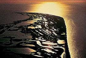 |
(#73000378) |
Kotzebue 67°06′51″N 163°41′09″W / 67.1142°N 163.6858°W |
Northwest Arctic | The archeological district comprises 114 ancient beach ridges which formed nearly 60 years apart. They provide a rare sequential look at over 5000 years of inhabitation. |
| 11 | Cape Nome Mining District Discovery Sites | 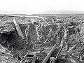 |
(#78000535) |
Nome 64°33′49″N 165°22′17″W / 64.56361°N 165.37139°W |
Nome | Significant for role in the history of gold mining in Alaska |
| 12 | Chaluka Site | 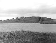 |
(#66000155) |
Nikolski 52°55′59″N 168°51′00″W / 52.933°N 168.850°W |
Aleutians West | Includes a large mound; yields information about origins of Aleuts |
| 13 | Chilkoot Trail and Dyea Site | 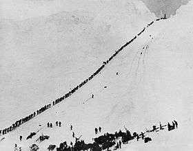 |
(#75002120) |
Skagway 59°38′00″N 135°17′00″W / 59.6333°N 135.2833°W |
Skagway | Major access route from the coast to Yukon goldfields in the late 1890s. |
| 14 | Church of the Holy Ascension | 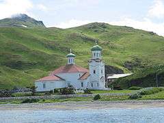 |
(#70000112) |
Unalaska 53°52′33″N 166°32′11″W / 53.8758°N 166.5363°W |
Aleutians West | Built in 1826 by the Russian American Fur Company to help acclimate indigenous population in Russian Alaska. |
| 15 | Dry Creek Archeological Site | .jpg) |
(#74000442) |
Healy, Alaska 63°54′33″N 149°01′00″W / 63.9092°N 149.0167°W |
Denali | This archeological site has provided evidence which supports the Bering land bridge theory |
| 16 | Dutch Harbor Naval Operating Base and Fort Mears, U.S. Army | 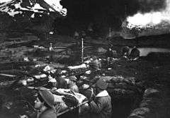 |
(#85002733) |
Unalaska 53°53′16″N 166°32′23″W / 53.8878°N 166.5397°W |
Aleutians West | Only US fortifications in the Aleutian Islands prior to WWII, attacked by the Japanese Navy during the Battle of Dutch Harbor in June 1943. |
| 17 | Eagle Historic District | |
(#70000919) |
Eagle 64°47′10″N 141°12′00″W / 64.7861°N 141.2°W |
Southeast Fairbanks | Historic district with over 100 well-preserved buildings from the Gold Rush years on the Yukon River. Roald Amundsen announced his successful traverse of the Northwest Passage from here in 1905 |
| 18 | Fort Durham Site | Upload image | (#78000529) |
Taku Harbor 58°02′01″N 134°00′01″W / 58.03361°N 134.00028°W |
Juneau | One of three Hudson's Bay Company posts set up in Alaska |
| 19 | Fort Glenn | 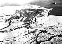 |
(#87001301) |
Fort Glenn 53°22′39″N 167°53′24″W / 53.37750°N 167.89000°W |
Aleutians West | Well preserved World War II defense base. |
| 20 | Fort William H. Seward | 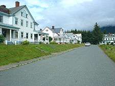 |
(#72000190) |
Haines 59°13′36″N 135°26′41″W / 59.2267°N 135.4446°W |
Haines | Last of a series of 11 military posts established in Alaska during the gold rush era |
| 21 | Gallagher Flint Station Archeological Site | 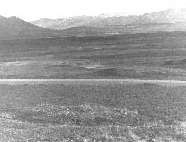 |
(#78003208) |
Sagwon 69°22′00″N 148°42′00″W / 69.36667°N 148.70000°W |
North Slope | Discovered in 1970 during the construction of the Trans-Alaska Pipeline, it was at the time the earliest dated archaeological site in northern Alaska. |
| 22 | Holy Assumption Orthodox Church | 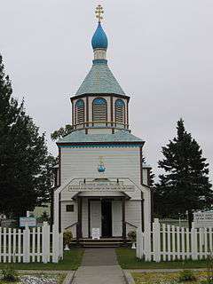 |
(#70000898) |
Kenai 60°33′09″N 151°15′59″W / 60.5524°N 151.2663°W |
Kenai Peninsula | Russian Orthodox church in Kenai, Alaska. |
| 23 | Ipiutak Site |  |
(#66000157) |
Point Hope Peninsula 68°20′49″N 166°45′47″W / 68.3469°N 166.7631°W |
North Slope | The type site for the Ipiutak culture |
| 24 | Iyatayet Site |  |
(#66000158) |
Cape Denbigh Peninsula 64°24′33″N 161°30′51″W / 64.40917°N 161.514028°W |
Nome | Shows evidence of several separate cultures, dating back as far as 6000 BC |
| 25 | Sheldon Jackson School | 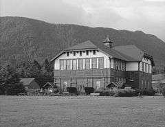 |
(#72000193) |
Sitka 57°03′06″N 135°19′22″W / 57.0516°N 135.3228°W |
Sitka | Oldest institution of higher learning in Alaska |
| 26 | Kake Cannery | .jpg) |
(#97001677) |
Kake 56°57′50″N 133°55′31″W / 56.9639°N 133.9253°W |
Petersburg | Built 1912-1940; significant for role in history of salmon canning in Alaska |
| 27 | Kennecott Mines | 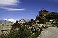 |
(#78003420) |
Kennecott 61°29′07″N 142°53′19″W / 61.4852°N 142.8885°W |
Valdez-Cordova | Site of discovery of copper in 1900 and subsequent mining activities |
| 28 | Kijik Archeological District | .jpg) |
(#94001644) |
Lake Clark National Park and Preserve 60°17′33″N 154°15′01″W / 60.2925°N 154.2503°W |
Lake and Peninsula | Related to the history of the Dena'ina Athabaskan Indians |
| 29 | Japanese Occupation Site, Kiska Island |  |
(#85002732) |
Kiska Island 51°58′02″N 177°29′31″E / 51.9672°N 177.4919°E |
Aleutians West | Site of the Japanese occupation of Kiska which along with nearby Attu were the only US land occupied by the Japanese during World War II |
| 30 | Kodiak Naval Operating Base and Forts Greely and Abercrombie | 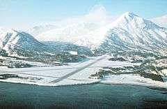 |
(#85002731) |
Kodiak 57°44′19″N 152°30′17″W / 57.73861°N 152.50472°W |
Kodiak Island | World War II-related facilities |
| 31 | Ladd Field | 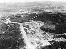 |
(#85002730) |
Fairbanks 64°50′15″N 147°36′52″W / 64.8375°N 147.6144°W |
Fairbanks North Star | Primary role during WWII was major stopping point for the Lend-Lease program. |
| 32 | Leffingwell Camp Site | 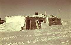 |
(#71001093) |
Flaxman Island 70°11′06″N 146°00′14″W / 70.1851°N 146.0039°W |
North Slope | Campsite of geologist and polar explorer Ernest de Koven Leffingwell on Arctic coast of Alaska, not far from Prudhoe Bay. |
| 33 | Nenana (river steamboat) | _Fairbanks%2C_Alaska.jpg) |
(#72001581) |
Fairbanks 64°50′16″N 147°46′06″W / 64.8377°N 147.7683°W |
Fairbanks North Star | River steamboat; only surviving wooden one of this type. |
| 34 | New Russia Site | Upload image | (#72001593) |
Yakutat 59°32′35″N 139°48′28″W / 59.54306°N 139.80778°W |
Yakutat | Site of Russian trading post attacked and destroyed by Tlingit natives. |
| 35 | Old Sitka |  |
(#66000166) |
6 miles (9.6 km) north of Sitka on Starrigavan Bay 57°07′53″N 135°22′15″W / 57.131389°N 135.370833°W |
Sitka | Also known as the Redoubt St. Archangel Michael Site, this was the site of a Russian-American Company settlement, established in 1799 and destroyed by Tlingit attack in 1802. |
| 36 | Onion Portage Archeological District |  |
(#72000191) |
Kiana 67°05′49″N 158°17′51″W / 67.0969°N 158.2975°W |
Northwest Arctic | Perhaps most important archaeological site in Alaska; caribou river crossing; human presence for millennia. |
| 37 | Palugvik Site | Upload image | (#66000957) |
Hawkins Island 60°31′01″N 146°03′00″W / 60.517°N 146.050°W |
Valdez-Cordova | Includes a large midden yielding information about Eskimo culture in the area. |
| 38 | Russian-American Building #29 |  |
(#87001282) |
Sitka 57°02′50″N 135°19′52″W / 57.047280°N 135.331157°W |
Sitka | Siding covered log building; dates back to the years after the 1867 purchase of Alaska. |
| 39 | Russian-American Magazin | .jpg) |
(#66000954) |
Kodiak 57°47′16″N 152°24′13″W / 57.78778°N 152.40361°W |
Kodiak Island | Storehouse building associated with the Russian and then the American trading companies active in Alaska. |
| 40 | Russian Bishop's House | 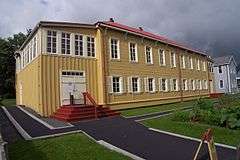 |
(#66000025) |
Sitka 57°02′55″N 135°19′38″W / 57.0485°N 135.3273°W |
Sitka | One of four surviving examples of Russian Colonial Style architecture in the Western Hemisphere. |
| 41 | St. Michael's Cathedral | 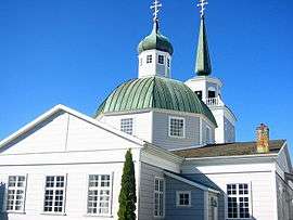 |
(#66000165) |
Sitka 57°02′59″N 135°20′05″W / 57.0497°N 135.3347°W |
Sitka | Primary evidence of Russian influence in North America. |
| 42 | Seal Island Historic District |  |
(#66000156) |
Pribilof Islands 57°N 170°W / 57°N 170°W |
Aleutians West | Historic buildings related to northern fur seal hunting in the Pribilof Islands and its restriction in 1911 and 1966. |
| 43 | Sitka Naval Operating Base and U.S. Army Coastal Defenses |  |
(#86003559) |
Sitka 57°02′49″N 135°21′52″W / 57.04694°N 135.36444°W |
Sitka | Commissioned as Sitka Naval Air Station in October 1939, it was redesignated the Naval Operating Base, July 1942. Protected the North Pacific during World War II.[6] |
| 44 | Sitka Spruce Plantation |  |
(#78000513) |
Unalaska 53°53′12″N 166°32′23″W / 53.8866°N 166.5397°W |
Aleutians West | First recorded afforestation project in North America; Russian settlers began in 1805; attempt to make Unalaska self-sufficient in timber. |
| 45 | Skagway Historic District and White Pass | 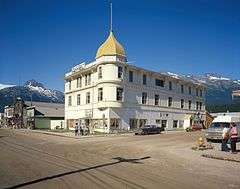 |
(#66000943) |
Skagway and White Pass 59°27′30″N 135°18′50″W / 59.4583°N 135.3139°W |
Skagway | Historic frontier Gold Rush town and trail leading to White Pass on the border of Canada. Over 100 buildings from the era survive, though they are threatened by continued development. Mentioned in The Call of the Wild by Jack London. |
| 46 | George C. Thomas Memorial Library | 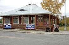 |
(#72001542) |
Fairbanks 64°50′41″N 147°43′40″W / 64.844735°N 147.727652°W |
Fairbanks North Star | The public library for Fairbanks from its construction in 1909 until the opening of the Noel Wien Public Library in 1977. Site of 1915 meeting between U.S. officials and native Alaskans to settle land claims. |
| 47 | Three Saints Bay Site | 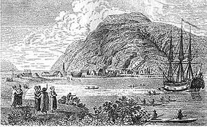 |
(#72001541) |
Old Harbor 57°08′00″N 153°30′00″W / 57.1333°N 153.5°W |
Kodiak Island | Site of the first Russian settlement in Alaska in 1784. |
| 48 | Wales Site | 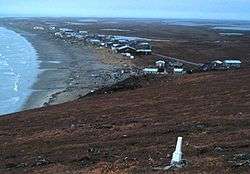 |
(#66000161) |
Wales 65°36′44″N 168°05′21″W / 65.6122°N 168.0892°W |
Nome | Site of first discovery of how the Thule culture followed the Birnirk culture in precontact whaling populations of the Alaskan shoreline. |
| 49 | Yukon Island Main Site |  |
(#66000955) |
Yukon Island 59°30′54″N 151°29′56″W / 59.5150°N 151.4989°W |
Kenai Peninsula | Related to the Kachemak Bay Culture. |
Historic areas of the NPS in Alaska
National Historic Sites, National Historical Parks, some National Monuments, and certain other areas listed in the National Park System are historic landmarks of national importance that are highly protected already, often before the inauguration of the NHL program in 1960, and are then often not also named NHLs per se. There are three of these in Alaska. The National Park Service lists these three together with the NHLs in the state,[7]
Cape Krusenstern National Monument is also an NHL and is listed above. The other two are:
| Landmark name |
Image | Date established[8] | Location | County | Description | |
|---|---|---|---|---|---|---|
| 1 | Klondike Gold Rush National Historical Park | 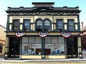 |
Skagway | Skagway | Park of Klondike Gold Rush, an NHL shared with Seattle, Washington. | |
| 2 | Sitka National Historical Park | 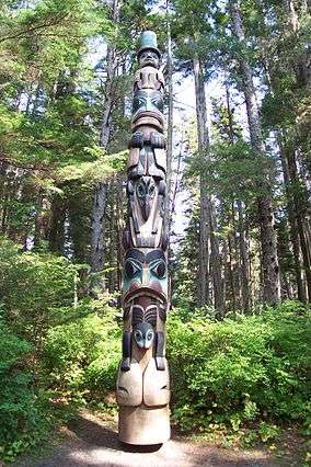 |
Sitka | Sitka |
Former NHLs in Alaska
| Landmark name[9] | Image | Date designated[9] |
Date withdrawn[9] | Locality[9][10] | Borough or Census Area[9] |
Description[10] | |
|---|---|---|---|---|---|---|---|
| 1 | Gambell Sites[11] | 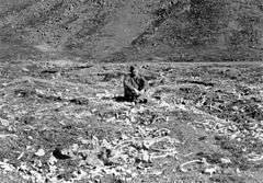 |
1962[11] | 1989[11] | Gambell [11] 63°46′34″N 171°42′3″W / 63.77611°N 171.70083°W |
Nome [11] | These five archeological sites established a chronology of human habitation on St. Lawrence Island, with evidence of four cultural phases of the Thule tradition, beginning about 2000 years before the present. Over the 20th century, the archeological value of the sites was largely destroyed due to ivory mining, and landmark designation was withdrawn.[11] |
| 2 | Sourdough Lodge[11] | .jpg) |
1978[11] | 1994[11] | Gakona [11] 62°18′07″N 145°18′07″W / 62.301940°N 145.30194°W |
Valdez-Cordova [11] | Built of logs in 1903-05, this was one of a number of roadhouses built along the Valdez Trail. It was destroyed by fire in 1992, leading to withdrawal of its landmark status. By the time of its destruction, it was one of the oldest continuously-operating roadhouses in Alaska.[11] |
See also
- National Register of Historic Places listings in Alaska
- History of Alaska
- Historic preservation
- National Register of Historic Places
- List of U.S. National Historic Landmarks by state
References
- ↑ NPS Alaska NHL List
- 1 2 3 "National Historic Landmarks Program: Questions & Answers". National Park Service. Retrieved 2007-09-21.
- 1 2 "Title 36 of the Code of Federal Regulations, Part 65". US Government Printing Office. Retrieved 2008-04-05.
- ↑ Numbers represent an ordering by significant words. Various colorings, defined here, differentiate National Historic Landmarks and historic districts from other NRHP buildings, structures, sites or objects.
- ↑ The eight-digit number below each date is the number assigned to each location in the National Register Information System database, which can be viewed by clicking the number.
- ↑ "Sitka Naval Operating Base and U.S. Army Coastal Defenses". National Historic Landmarks Quioklinks. National Park Service. Retrieved 18 March 2012.
- ↑ These are listed on p.110 of "National Historic Landmarks Survey: List of National Historic Landmarks by State", November 2007 version.
- ↑ Date of listing as National Historic Site or similar designation, from various sources in articles indexed.
- 1 2 3 4 5 National Park Service (June 2011). "National Historic Landmarks Survey: List of NHLs by State" (PDF). Retrieved 2011-07-04.
- 1 2 National Park Service. "National Historic Landmark Program: NHL Database". Retrieved 2007-10-04.
- 1 2 3 4 5 6 7 8 9 10 11 12 National Park Service. "National Historic Landmark Program: Withdrawal of NHL Designation". Retrieved 2007-10-04.
External links
- National Historic Landmark Program at the National Park Service
- Lists of National Historic Landmarks
Juneau (capital) | ||
| Topics |
|  |
| Society |
| |
| Regions | ||
| Largest cities | ||
| Boroughs | ||
| Census Areas | ||
| Topics | |
|---|---|
| Lists by states |
|
| Lists by insular areas | |
| Lists by associated states | |
| Other areas | |
| |