Gunnison County, Colorado
| Gunnison County, Colorado | |
|---|---|
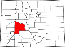 Location in the U.S. state of Colorado | |
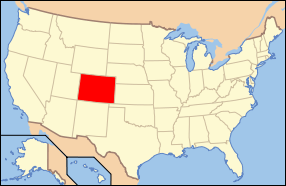 Colorado's location in the U.S. | |
| Founded | March 9, 1877 |
| Named for | John W. Gunnison |
| Seat | Gunnison |
| Largest city | Gunnison |
| Area | |
| • Total | 3,260 sq mi (8,443 km2) |
| • Land | 3,239 sq mi (8,389 km2) |
| • Water | 21 sq mi (54 km2), 0.6% |
| Population (est.) | |
| • (2015) | 16,067 |
| • Density | 4.7/sq mi (2/km²) |
| Congressional district | 3rd |
| Time zone | Mountain: UTC-7/-6 |
| Website |
www |
Gunnison County is the fifth-most extensive of the 64 counties in the U.S. state of Colorado. As of the 2010 census, the population was 15,324.[1] The county seat is Gunnison.[2] The county was named for John W. Gunnison, a United States Army officer and captain in the Army Topographical Engineers, who surveyed for the transcontinental railroad in 1853.
Daniel I.J. Thornton, the Republican governor of Colorado from 1951 to 1955, operated a ranch in Gunnison County. The city of Thornton, Colorado, north of Denver, is named in his honor.
History
Archeological studies have dated the Ute people's appearance in the Uncompahgre region of Colorado as early as 1150 A.D. Possibilities exist that they are descendants of an earlier people living in the area as far back as 1500 B.C.[3] They were a nomadic race of dark skin moving about the Western Slope of Colorado in the various parts of the year.[4] In the early to mid-1600s the Spaniards of New Mexico introduced the horse which changed their patterns of hunting taking them across the divide to the eastern slopes and into conflict with the Plains Indians which soon became their bitter enemies.[5]
The first recorded expedition of Western Colorado wilderness was led by Don Juan Rivera in 1765. In 1776, two Spanish priests, Fathers Escalante and Dominguez, led a party into the area around Montrose and Paonia.[6]
The 1830s brought the mountainmen into the area to trap beaver. An old cabin located on Cochetopa Creek discovered by Sidney Jocknick was most likely built between 1830 and 1840 and a rude fort was discovered on a tributary of Tomichi Creek bore signs of a conflict.[7]
In 1853, Capt. John W. Gunnison surveyed the area for the transcontinental railroad route.[8]
In 1858 gold was discovered near Denver bringing the white man across the divide into the western slope in search of the precious metal. In 1859 a party settled on Texas Gulch in Union Park.[9]
Placer gold was found at Washington Gulch in 1861 as part of the Colorado Gold Rush.[10]
In 1861 the Territory of Colorado was organized. The territorial governor was made ex officio Superintentant of Indian Affairs. A conference on October 1, 1863 established a boundary line for a reservation.[11] This treaty averted a possible dangerous situation by giving the Utes some cattle and sheep, a blacksmith and 20,000 dollars a year in goods and provisions. The government failed to fulfill any these obligations straining the relations further.[12] The treaty of 1868 recognized Chief Ouray as the sole spokesman for seven tribes of the Ute People. He held this power over his people through diplomacy and understanding.[13]
The Los Pinos Agency was developed through the Treaties of 1868 and 1873. The first agent was 2nd Lieutenant Calvin T. Speer. In 1871 a cow camp was started near the present site of Gunnison with James P. Kelley in charge. In this year, Jabez Nelson Trask, a Harvard grad, relieved Speer as agent upon orders from Governor Edward M. McCook.[14] In 1872 Trask was replaced by Charles Adams.
In 1875 orders from Washington to move the agency to the Uncomphgre Valley were completed in November.[15]
In 1876 Colorado entered the Union and Gunnison County was formed. 1879 was a year of expansion due to the miners, speculators and adventurers seeking wealth. The cattle industry was established by 1880. The short growing season was not conducive to farming and the ranchers had to level fields and construct irrigation ditches to water the fields for hay.
Geography
According to the U.S. Census Bureau, the county has a total area of 3,260 square miles (8,400 km2), of which 3,239 square miles (8,390 km2) is land and 21 square miles (54 km2) (0.6%) is water.[16] It is the fifth-largest county by area in Colorado. The county seat is Gunnison, Colorado which is located in a wide valley at the confluence of Tomichi Creek and Gunnison River. The county rests in the Gunnison Basin formed by the Continental Divide to the east, Collegiate Peaks Wilderness rises in the northeast, Maroon Bells-Snowmass Wilderness and the White River National Forest to the north, the West Elk Wilderness rises in the west of the county with Delta and Montrose Counties on its western slopes. The Uncompahgre Wilderness rises in the southwest of the county and the Powderhorn Wilderness east of there and Saquache County being south of Gunnison county eastward over to Marshall Pass southeast of the county.[17]
Taylor Park Reservoir is a man-made lake created by the Taylor Dam constructed in 1934 with appropriations of 2,725,000 dollars.[18]
Adjacent counties
- Pitkin County, Colorado — north
- Chaffee County, Colorado — east
- Saguache County, Colorado — southeast
- Hinsdale County, Colorado — south
- Ouray County, Colorado — southwest
- Delta County, Colorado — west
- Montrose County, Colorado — west
- Mesa County, Colorado — northwest
Demographics
| Historical population | |||
|---|---|---|---|
| Census | Pop. | %± | |
| 1880 | 8,235 | — | |
| 1890 | 4,359 | −47.1% | |
| 1900 | 5,331 | 22.3% | |
| 1910 | 5,897 | 10.6% | |
| 1920 | 5,590 | −5.2% | |
| 1930 | 5,527 | −1.1% | |
| 1940 | 6,192 | 12.0% | |
| 1950 | 5,716 | −7.7% | |
| 1960 | 5,477 | −4.2% | |
| 1970 | 7,578 | 38.4% | |
| 1980 | 10,689 | 41.1% | |
| 1990 | 10,273 | −3.9% | |
| 2000 | 13,956 | 35.9% | |
| 2010 | 15,324 | 9.8% | |
| Est. 2015 | 16,067 | [19] | 4.8% |
| U.S. Decennial Census[20] 1790-1960[21] 1900-1990[22] 1990-2000[23] 2010-2015[1] | |||
2000
As of the census[24] of 2000, there were 13,956 people, 5,649 households, and 2,965 families residing in the county. The population density was 4 people per square mile (2/km²). There were 9,135 housing units at an average density of 3 per square mile (1/km²). The racial makeup of the county was 95.08% White, 0.49% Black or African American, 0.70% Native American, 0.54% Asian, 0.04% Pacific Islander, 1.44% from other races, and 1.72% from two or more races. 5.02% of the population were Hispanic or Latino of any race.
There were 5,649 households out of which 24.10% had children under the age of 18 living with them, 44.20% were married couples living together, 5.40% had a female householder with no husband present, and 47.50% were non-families. 27.20% of all households were made up of individuals and 4.60% had someone living alone who was 65 years of age or older. The average household size was 2.30 and the average family size was 2.84.
In the county the population was spread out with 17.90% under the age of 18, 21.10% from 18 to 24, 32.90% from 25 to 44, 21.20% from 45 to 64, and 6.90% who were 65 years of age or older. The median age was 30 years. For every 100 females there were 118.30 males. For every 100 females age 18 and over, there were 120.90 males.
The median income for a household in the county was $36,916, and the median income for a family was $51,950. Males had a median income of $30,885 versus $25,000 for females. The per capita income for the county was $21,407. About 6.00% of families and 15.00% of the population were below the poverty line, including 9.40% of those under age 18 and 7.20% of those age 65 or over.
2010
Total population for Gunnison County in the year 2010 was 15,324. There were 8,306 males and 7,018 females. The median age was 35.7 years old. Of the races, 14,152 were white, 92.4 percent; 1,255 were Hispanic or Latino (of any race), 8.2 percent; 510 claimed other race, 3.3 percent; 208 were American Indian and Alaska Native, 1.4 percent; 100 were Asian, 0.7 percent.
Total households were 6,516, 100.0 percent; Family households (families) 3,454, 53.0 percent, ("Family households" were based on a householder and one or more other people related to the householder by birth, marriage, or adoption. Same-sex married couples were not included.)
Occupied housing units consisted of 6,516 units, being 100.0 percent, with 3,900 or 59.9 percent being owner-occupied housing units; 2,616 or 40.1 percent being renters.
There were estimated 9,155 employed persons and 459 unemployed. 4,601 people drove to work alone and 1,027 car-pooled; 1,297 people walked to work and 1,052 took other means. Management, business, science, and arts occupations included 2,895 persons; Service occupations included 1,828 persons; Sales and office occupations included 2,192 persons; Natural resources, construction, and maintenance occupations included 1,635 persons; Production, transportation, and material moving occupations included 605 persons. 6,635 people were private wage and salary workers; 1,865 people were government workers; 655 people were self-employed and 49,356 dollars was the median household income and 67,333 dollars was the mean household income.
Recreation

State parks
National recreation areas
National forests
National wilderness areas
- Collegiate Peaks Wilderness
- Fossil Ridge Wilderness
- Maroon Bells-Snowmass Wilderness
- Powderhorn Wilderness
- Raggeds Wilderness
- Uncompahgre Wilderness
- West Elk Wilderness
Trails
- American Discovery Trail
- Colorado Trail
- Continental Divide National Scenic Trail
- Old Spanish National Historic Trail
Bicycle routes
Scenic byways
- West Elk Loop Scenic Byway
- Silver Thread Scenic Byway
Communities
In popular culture
In 2007, the science fiction horror film Aliens vs. Predator: Requiem was set in and around the town of Gunnison.
See also
- Outline of Colorado
- Index of Colorado-related articles
- National Register of Historic Places listings in Gunnison County, Colorado
References
- 1 2 "State & County QuickFacts". United States Census Bureau. Retrieved June 8, 2014.
- ↑ "Find a County". National Association of Counties. Retrieved 2011-06-07.
- ↑ Wormington, H. M. and Robert H. Lister. Archaeological Investigations on the Uncompahgre Plateau in West Central Colorado. Proceedings No. 2, Denver Museum of Natural History (Denver, Colorado, March, 1956), p.124.
- ↑ Rockwell (1956), pp. 11–12
- ↑ Rockwell (1956), pp. 15–16
- ↑ Rockwell (1956), pp. 54–59
- ↑ Jocknick (1913), pp. 319–320
- ↑ Mumey (1955), pp. 48–49
- ↑ United States Forest Service Historical Records, Gunnison, Colorado, miscellaneous materials.
- ↑ Voynick (1992), p. 30
- ↑ Rockwell (1956), pp. 68–69
- ↑ Rockwell (1956), pp. 70–71
- ↑ Jocknick (1913), pp. 117–120
- ↑ Jocknick (1913), pp. 37–38
- ↑ Rockwell (1956), pp. 106–107
- ↑ "US Gazetteer files: 2010, 2000, and 1990". United States Census Bureau. 2011-02-12. Retrieved 2011-04-23.
- ↑ Gunnison Basin Public Lands. Colorado: Forest Service Series Map, 2008. United States Department of Agriculture.
- ↑ Sibley, George. Water Wranglers. Colorado River District, Grand Junction, Colorado. 2012. P. 36.
- ↑ "County Totals Dataset: Population, Population Change and Estimated Components of Population Change: April 1, 2010 to July 1, 2015". Retrieved July 2, 2016.
- ↑ "U.S. Decennial Census". United States Census Bureau. Retrieved June 8, 2014.
- ↑ "Historical Census Browser". University of Virginia Library. Retrieved June 8, 2014.
- ↑ "Population of Counties by Decennial Census: 1900 to 1990". United States Census Bureau. Retrieved June 8, 2014.
- ↑ "Census 2000 PHC-T-4. Ranking Tables for Counties: 1990 and 2000" (PDF). United States Census Bureau. Retrieved June 8, 2014.
- ↑ "American FactFinder". United States Census Bureau. Retrieved 2011-05-14.
Bibliography
- Jocknick, Sidney (1913). Early Days on the Western Slope of Colorado – 1870 to 1883. Denver, CO: The Carson-Harper Company.
- Mumey, Nolie (1955). John Williams Gunnison. Denver, CO: Artcraft Press.
- Rockwell, Wilson (1956). The Utes – a Forgotten People. Denver, CO: Sage Books.
- Voynick, Stephen M. (1992). Colorado Gold: from the Pike's Peak Rush to the Present. Missoula, MO: Mountain Press Publishing Company. ISBN 9780878424559.
External links
- Gunnison County official website
- Gunnison-Crested Butte Tourism Association
- "Colorado County Evolution", by Don Stanwyck
- Colorado Historical Society
| Wikimedia Commons has media related to Gunnison County, Colorado. |
 |
Mesa County | Pitkin County | | |
| Delta County and Montrose County | |
Chaffee County | ||
| ||||
| | ||||
| Ouray County | Hinsdale County | Saguache County |
Municipalities and communities of Gunnison County, Colorado, United States | ||
|---|---|---|
| City | | |
| Towns | ||
| Unincorporated communities | ||
| Ghost town | ||

Coordinates: 38°40′N 107°01′W / 38.67°N 107.01°W