Mount Massive Wilderness
| Mount Massive Wilderness | |
|---|---|
|
IUCN category Ib (wilderness area) | |
|
Mount Massive | |
 | |
| Location | Lake County, Colorado, USA |
| Nearest city | Leadville, CO |
| Coordinates | 39°11′27″N 106°27′56″W / 39.19083°N 106.46556°WCoordinates: 39°11′27″N 106°27′56″W / 39.19083°N 106.46556°W[1] |
| Area | 30,540 acres (123.6 km2) |
| Established | 1980 |
| Governing body | U.S. Forest Service / Fish and Wildlife Service |
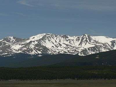
The Mount Massive Wilderness is a federally designated wilderness area in the Sawatch Range, located in the U.S. state of Colorado. It is operated jointly by the United States Forest Service and the Fish and Wildlife Service as part of the San Isabel National Forest and the Leadville National Fish Hatchery. It is 30,540 acres (123.6 km2) in size, with 27,980 acres (113.2 km2) in San Isabel National Forest and 2,560 acres (10.4 km2) in Leadville National Fish Hatchery, and it was designated by the US Congress in 1980. The name comes from Mount Massive, the second highest peak in Colorado, located inside the wilderness. Elevations in the wilderness range from 9,700 feet (3,000 m) to 14,421 feet (4,396 m). It is the only federally designated wilderness area within the National Fish Hatchery System.[2][3]
On the west side, the Continental Divide separates the Mount Massive Wilderness from the Hunter-Fryingpan Wilderness, part of the White River National Forest.
Trailheads accessing the wilderness are:
- Hagerman Pass Road – The Colorado Trail, Native Lake and Windsor Lake Trailhead
- US Fish Hatchery – The Rock Creek Trailhead
- Halfmoon Creek Trailhead – Mt. Elbert/Mt. Massive Trailhead and the North Halfmoon Lake Trailhead
References
- ↑ "Mount Massive Wilderness". Geographic Names Information System. United States Geological Survey. Retrieved August 12, 2012.
- ↑ "Mount Massive Wilderness". Wilderness.net. Retrieved August 12, 2012.
- ↑ "Mount Massive Wilderness Area". Colorado Wilderness. Retrieved August 12, 2012.
Further reading
Maps:
- San Isabel National Forest Map
- Trails Illustrated Independence Pass and Holy Cross maps
- USGS Homestake, Mount Massive, and Mount Champion quadrangles