Arapahoe County, Colorado
| Arapahoe County, Colorado | |
|---|---|
|
Logo | |
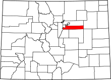 Location in the U.S. state of Colorado | |
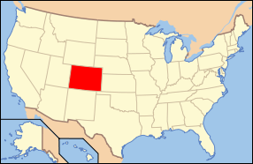 Colorado's location in the U.S. | |
| Founded | November 1, 1861 |
| Named for | The Arapaho Nation[1] |
| Seat | Littleton |
| Largest city | Aurora |
| Area | |
| • Total | 805 sq mi (2,085 km2) |
| • Land | 798 sq mi (2,067 km2) |
| • Water | 7.3 sq mi (19 km2), 0.9% |
| Population (est.) | |
| • (2015) | 631,096 |
| • Density | 606/sq mi (234/km²) |
| Congressional districts | 1st, 4th, 6th |
| Time zone | Mountain: UTC-7/-6 |
| Website |
www |
|
Footnotes: | |
Arapahoe County (/əˈræpəhoʊ/ ə-RAP-ə-ho) is one of the 64 counties in the U.S. state of Colorado. As of the 2010 census, the population was 572,003,[2] making it the third-most populous county in Colorado. The county seat is Littleton,[3] and the most populous city is Aurora. The county was named for the Arapaho Native American tribe who once lived in the region.[1]
Arapahoe County is part of the Denver-Aurora-Lakewood, CO Metropolitan Statistical Area. Arapahoe County calls itself "Colorado's First County" since its origins predate the Pike's Peak Gold Rush.
History
On August 25, 1855, the Kansas Territorial Legislature created a huge Arapahoe County to govern the entire western portion of the Territory of Kansas. The county was named for the Arapaho Nation who lived in the region.[1]
In July 1858, gold was discovered along the South Platte River in Arapahoe County (in present-day Englewood). This discovery precipitated the Pike's Peak Gold Rush. Many residents of the mining region felt disconnected from the remote territorial governments of Kansas and Nebraska, so they voted to form their own Territory of Jefferson on October 24, 1859. The following month, the Jefferson Territorial Legislature organized 12 counties for the new territory, including a smaller Arrappahoe County. Denver City served as the county seat of Arapahoe County.
The Jefferson Territory never received federal sanction, and instead on February 28, 1861, U.S. President James Buchanan signed an act organizing the Territory of Colorado.[4] On November 1, 1861, the Colorado General Assembly organized the 17 original counties of Colorado, including a new Arapahoe County. Arapahoe County originally stretched from the line of present-day Sheridan Boulevard 160 miles (258 kilometers) east to the Kansas border, and from the line of present-day County Line Road 30 miles (48 kilometers) north to the Parallel 40° North (168th Avenue). Denver City served as the county seat of Arapahoe County until 1902.
In 1901, the Colorado General Assembly voted to split Arapahoe County into three parts: a new consolidated City and County of Denver, a new Adams County, and the remainder of the Arapahoe County to be renamed South Arapahoe County. A ruling by the Colorado Supreme Court, subsequent legislation, and a referendum delayed the reorganization until November 15, 1902. Governor James Bradley Orman designated Littleton as the temporary county seat of South Arapahoe County. On April 11, 1903, the Colorado General Assembly changed the name of South Arapahoe County back to Arapahoe County. On November 8, 1904, Arapahoe County voters chose Littleton over Englewood by a vote of 1310 to 829 to be the permanent county seat.
Geography
According to the U.S. Census Bureau, the county has a total area of 805 square miles (2,080 km2), of which 798 square miles (2,070 km2) is land and 7.3 square miles (19 km2) (0.9%) is water.[5] The county measures 72 miles (116 kilometers) east to west and 4 to 12 miles (6 to 19 kilometers) south to north.
Two exclaves of Arapahoe County are entirely surrounded by the City and County of Denver, the City of Glendale and the Holly Hills neighborhood, a census-designated place.
Adjacent counties
- City and County of Denver – northwest and exclaves
- Adams County – north
- Washington County – east
- Lincoln County – southeast
- Elbert County – south
- Douglas County – southwest
- Jefferson County – west
Major highways
- Interstate 25
- Interstate 70
- Interstate 225
- E-470 (tollway)
State park
Historic trails
Recreation trails
- Highline Canal National Recreation Trail
- Platte River Greenway National Recreation Trail
Demographics
| Historical population | |||
|---|---|---|---|
| Census | Pop. | %± | |
| 1870 | 6,829 | — | |
| 1880 | 38,644 | 465.9% | |
| 1890 | 132,135 | 241.9% | |
| 1900 | 153,017 | 15.8% | |
| 1910 | 10,263 | −93.3% | |
| 1920 | 13,766 | 34.1% | |
| 1930 | 22,647 | 64.5% | |
| 1940 | 32,150 | 42.0% | |
| 1950 | 52,125 | 62.1% | |
| 1960 | 113,426 | 117.6% | |
| 1970 | 162,142 | 42.9% | |
| 1980 | 293,621 | 81.1% | |
| 1990 | 391,511 | 33.3% | |
| 2000 | 487,967 | 24.6% | |
| 2010 | 572,003 | 17.2% | |
| Est. 2015 | 631,096 | [6] | 10.3% |
| U.S. Decennial Census[7] 1790-1960[8] 1900-1990[9] 1990-2000[10] 2010-2015[2] | |||
As of the census of 2000, there were 487,967 people, 190,909 households, and 125,809 families residing in the county. The population density was 608 people per square mile (235/km²). There were 196,835 housing units at an average density of 245 per square mile (95/km²). The racial makeup of the county was 79.93% White, 7.67% Black or African American, 0.66% Native American, 3.95% Asian, 0.12% Pacific Islander, 4.51% from other races, and 3.16% from two or more races. 11.81% of the population were Hispanic or Latino of any race.
There were 190,909 households out of which 34.90% had children under the age of 18 living with them, 51.20% were married couples living together, 10.60% had a female householder with no husband present, and 34.10% were non-families. 27.00% of all households were made up of individuals and 5.90% had someone living alone who was 65 years of age or older. The average household size was 2.53 and the average family size was 3.11.
In the county the population was spread out with 26.70% under the age of 18, 8.60% from 18 to 24, 33.10% from 25 to 44, 23.00% from 45 to 64, and 8.60% who were 65 years of age or older. The median age was 34 years. For every 100 females there were 97.10 males. For every 100 females age 18 and over, there were 94.20 males.
The median income for a household in the county was $53,570, and the median income for a family was $63,875. Males had a median income of $41,601 versus $31,612 for females. The per capita income for the county was $28,147. About 4.20% of families and 5.80% of the population were below the poverty line, including 7.00% of those under age 18 and 5.10% of those age 65 or over.
Politics
Arapahoe County was once a Republican stronghold, and a classic bastion of suburban conservatism. However, the margin gradually declined in the 1990s and early 2000s, reflecting the county's growing and more diverse population. In 2008, the county swung over dramatically to support Barack Obama, Democrat to carry it since 1964, and only the second since 1944. Four years earlier, George W. Bush had won the county by four points; in 2008, Obama won it by 13 points. It voted for Obama by a similar margin in 2012, and provided much of Hillary Clinton's statewide margin in 2016.
| Year | Republican | Democrat |
|---|---|---|
| 2016 | 38.66% 116,711 | 52.73% 159,171 |
| 2012 | 43.99% 125,588 | 53.90% 153,905 |
| 2008 | 42.78% 113,868 | 55.69% 148,224 |
| 2004 | 51.42% 119,475 | 47.45% 110,262 |
| 2000 | 51.47% 97,768 | 43.49% 82,614 |
| 1996 | 50.78% 82,778 | 41.90% 68,306 |
| 1992 | 39.26% 72,221 | 36.21% 66,607 |
| 1988 | 60.23% 95,926 | 38.37% 61,113 |
| 1984 | 71.91% 107,556 | 26.67% 39,891 |
| 1980 | 62.19% 79,594 | 23.55% 30,148 |
| 1976 | 63.45% 63,154 | 33.84% 33,685 |
| 1972 | 72.23% 52,283 | 25.74% 18,631 |
| 1968 | 59.64% 33,712 | 32.85% 18,569 |
| 1964 | 44.92% 23,071 | 54.40% 27,940 |
| 1960 | 60.06% 26,379 | 39.62% 17,400 |
Communities
Cities
- Aurora (part; also extends into Douglas County and Adams County)
- Centennial
- Cherry Hills Village
- Englewood
- Glendale
- Greenwood Village
- Littleton
- Sheridan
- Foxfield
- Bow Mar (part; also extends into Jefferson County)
- Columbine Valley
Towns
Census-designated places
Unincorporated communities
See also
- Outline of Colorado
- Index of Colorado-related articles
- Colorado census statistical areas
- Denver–Aurora–Boulder Combined Statistical Area
- Front Range Urban Corridor
- National Register of Historic Places listings in Arapahoe County, Colorado
References
- 1 2 3 Gannett, Henry (1905). The Origin of Certain Place Names in the United States. p. 27.
- 1 2 "State & County QuickFacts". United States Census Bureau. Retrieved June 7, 2014.
- ↑ "Find a County". National Association of Counties. Archived from the original on 2011-05-31. Retrieved 2011-06-07.
- ↑ "An Act to provide a temporary Government for the Territory of Colorado" (PDF). Thirty-sixth United States Congress. 1861-02-28. Archived (PDF) from the original on 26 November 2007. Retrieved 2007-11-26.
- ↑ "US Gazetteer files: 2010, 2000, and 1990". United States Census Bureau. 2011-02-12. Retrieved 2011-04-23.
- ↑ "County Totals Dataset: Population, Population Change and Estimated Components of Population Change: April 1, 2010 to July 1, 2015". Retrieved July 2, 2016.
- ↑ "U.S. Decennial Census". United States Census Bureau. Archived from the original on May 11, 2015. Retrieved June 7, 2014.
- ↑ "Historical Census Browser". University of Virginia Library. Retrieved June 7, 2014.
- ↑ "Population of Counties by Decennial Census: 1900 to 1990". United States Census Bureau. Retrieved June 7, 2014.
- ↑ "Census 2000 PHC-T-4. Ranking Tables for Counties: 1990 and 2000" (PDF). United States Census Bureau. Retrieved June 7, 2014.
- ↑ "Dave Leip's Atlas of U.S. Presidential Elections". Retrieved 2011-06-11.
External links
- Arapahoe County Government website
- Colorado County Evolution by Don Stanwyck
- Colorado Historical Society
 |
City and County of Denver | Adams County | | |
| Jefferson County | |
Washington County | ||
| ||||
| | ||||
| Douglas County | Elbert County | Lincoln County |
Municipalities and communities of Arapahoe County, Colorado, United States | ||
|---|---|---|
| Cities | | |
| Towns | ||
| CDPs | ||
| Footnotes | ‡This populated place also has portions in an adjacent county or counties | |

Coordinates: 39°38′N 104°20′W / 39.64°N 104.33°W