Cize, Ain
| Cize | |
|---|---|
|
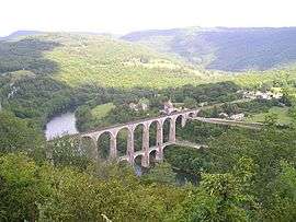
Cize–Bolozon railroad viaduct | |
 Cize | |
|
Location within Auvergne-Rhône-Alpes region  Cize | |
| Coordinates: 46°12′15″N 5°26′45″E / 46.2042°N 5.4458°ECoordinates: 46°12′15″N 5°26′45″E / 46.2042°N 5.4458°E | |
| Country | France |
| Region | Auvergne-Rhône-Alpes |
| Department | Ain |
| Arrondissement | Bourg-en-Bresse |
| Canton | Ceyzériat |
| Intercommunality | La Vallière |
| Government | |
| • Mayor (2008–2014) | Joël Bibet |
| Area1 | 4.52 km2 (1.75 sq mi) |
| Population (2008)2 | 158 |
| • Density | 35/km2 (91/sq mi) |
| Time zone | CET (UTC+1) |
| • Summer (DST) | CEST (UTC+2) |
| INSEE/Postal code | 01106 / 01250 |
| Elevation |
264–540 m (866–1,772 ft) (avg. 433 m or 1,421 ft) |
|
1 French Land Register data, which excludes lakes, ponds, glaciers > 1 km² (0.386 sq mi or 247 acres) and river estuaries. 2 Population without double counting: residents of multiple communes (e.g., students and military personnel) only counted once. | |
Cize is a commune in the Ain department in eastern France.
Population
| Historical population | ||
|---|---|---|
| Year | Pop. | ±% |
| 1793 | 200 | — |
| 1800 | 148 | −26.0% |
| 1806 | 184 | +24.3% |
| 1821 | 210 | +14.1% |
| 1831 | 168 | −20.0% |
| 1836 | 167 | −0.6% |
| 1841 | 196 | +17.4% |
| 1846 | 201 | +2.6% |
| 1851 | 222 | +10.4% |
| 1856 | 226 | +1.8% |
| 1861 | 223 | −1.3% |
| 1866 | 197 | −11.7% |
| 1872 | 206 | +4.6% |
| 1876 | 179 | −13.1% |
| 1881 | 188 | +5.0% |
| 1886 | 186 | −1.1% |
| 1891 | 192 | +3.2% |
| 1896 | 177 | −7.8% |
| 1901 | 196 | +10.7% |
| 1906 | 171 | −12.8% |
| 1911 | 167 | −2.3% |
| 1921 | 154 | −7.8% |
| 1926 | 126 | −18.2% |
| 1931 | 237 | +88.1% |
| 1936 | 172 | −27.4% |
| 1946 | 155 | −9.9% |
| 1954 | 137 | −11.6% |
| 1962 | 136 | −0.7% |
| 1968 | 126 | −7.4% |
| 1975 | 128 | +1.6% |
| 1982 | 108 | −15.6% |
| 1990 | 112 | +3.7% |
| 1999 | 127 | +13.4% |
| 2008 | 158 | +24.4% |
See also
References
| Wikimedia Commons has media related to Cize, Ain. |
This article is issued from Wikipedia - version of the 3/15/2016. The text is available under the Creative Commons Attribution/Share Alike but additional terms may apply for the media files.