Cressin-Rochefort
| Cressin-Rochefort | |
|---|---|
|
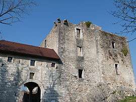
Chateau of Rochefort sur Séran | |
 Cressin-Rochefort | |
|
Location within Auvergne-Rhône-Alpes region  Cressin-Rochefort | |
| Coordinates: 45°46′34″N 5°45′36″E / 45.776°N 5.76°ECoordinates: 45°46′34″N 5°45′36″E / 45.776°N 5.76°E | |
| Country | France |
| Region | Auvergne-Rhône-Alpes |
| Department | Ain |
| Arrondissement | Belley |
| Canton | Belley |
| Intercommunality | Belley Bas Bugey |
| Government | |
| • Mayor (2008–2014) | Pierre Gonod |
| Area1 | 7.93 km2 (3.06 sq mi) |
| Population (2008)2 | 361 |
| • Density | 46/km2 (120/sq mi) |
| Time zone | CET (UTC+1) |
| • Summer (DST) | CEST (UTC+2) |
| INSEE/Postal code | 01133 / 01350 |
| Elevation |
225–554 m (738–1,818 ft) (avg. 230 m or 750 ft) |
|
1 French Land Register data, which excludes lakes, ponds, glaciers > 1 km² (0.386 sq mi or 247 acres) and river estuaries. 2 Population without double counting: residents of multiple communes (e.g., students and military personnel) only counted once. | |
Cressin-Rochefort is a commune in the Ain department in eastern France.
Population
| Historical population | ||
|---|---|---|
| Year | Pop. | ±% |
| 1793 | 374 | — |
| 1800 | 231 | −38.2% |
| 1806 | 415 | +79.7% |
| 1821 | 521 | +25.5% |
| 1831 | 559 | +7.3% |
| 1836 | 537 | −3.9% |
| 1841 | 570 | +6.1% |
| 1846 | 587 | +3.0% |
| 1851 | 551 | −6.1% |
| 1856 | 565 | +2.5% |
| 1861 | 530 | −6.2% |
| 1866 | 547 | +3.2% |
| 1872 | 530 | −3.1% |
| 1876 | 532 | +0.4% |
| 1881 | 468 | −12.0% |
| 1886 | 432 | −7.7% |
| 1891 | 427 | −1.2% |
| 1896 | 444 | +4.0% |
| 1901 | 404 | −9.0% |
| 1906 | 401 | −0.7% |
| 1911 | 404 | +0.7% |
| 1921 | 345 | −14.6% |
| 1926 | 321 | −7.0% |
| 1931 | 276 | −14.0% |
| 1936 | 260 | −5.8% |
| 1946 | 256 | −1.5% |
| 1954 | 197 | −23.0% |
| 1962 | 183 | −7.1% |
| 1968 | 166 | −9.3% |
| 1975 | 179 | +7.8% |
| 1982 | 216 | +20.7% |
| 1990 | 250 | +15.7% |
| 1999 | 308 | +23.2% |
| 2008 | 361 | +17.2% |
See also
References
| Wikimedia Commons has media related to Cressin-Rochefort. |
This article is issued from Wikipedia - version of the 2/12/2016. The text is available under the Creative Commons Attribution/Share Alike but additional terms may apply for the media files.