Saint-Paul-de-Varax
| Saint-Paul-de-Varax | |
|---|---|
|
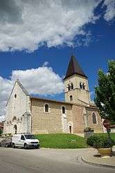
Church | |
 Saint-Paul-de-Varax | |
|
Location within Auvergne-Rhône-Alpes region  Saint-Paul-de-Varax | |
| Coordinates: 46°05′59″N 5°07′44″E / 46.0997°N 5.1289°ECoordinates: 46°05′59″N 5°07′44″E / 46.0997°N 5.1289°E | |
| Country | France |
| Region | Auvergne-Rhône-Alpes |
| Department | Ain |
| Arrondissement | Bourg-en-Bresse |
| Canton | Villars-les-Dombes |
| Intercommunality | Centre Dombes |
| Government | |
| • Mayor (2008–2014) | Gérard Dédedjian |
| Area1 | 25.97 km2 (10.03 sq mi) |
| Population (2008)2 | 1,497 |
| • Density | 58/km2 (150/sq mi) |
| Time zone | CET (UTC+1) |
| • Summer (DST) | CEST (UTC+2) |
| INSEE/Postal code | 01383 / 01240 |
| Elevation |
245–281 m (804–922 ft) (avg. 268 m or 879 ft) |
|
1 French Land Register data, which excludes lakes, ponds, glaciers > 1 km² (0.386 sq mi or 247 acres) and river estuaries. 2 Population without double counting: residents of multiple communes (e.g., students and military personnel) only counted once. | |
Saint-Paul-de-Varax is a commune in the Ain department in eastern France.
It is situated between Bourg-en-Bresse and Lyon. Its castle, which belonged to the Rivérieulx de Varax family since the 13th century, is closed to the public.
Population
| Historical population | ||
|---|---|---|
| Year | Pop. | ±% |
| 1793 | 526 | — |
| 1800 | 520 | −1.1% |
| 1806 | 309 | −40.6% |
| 1821 | 469 | +51.8% |
| 1831 | 453 | −3.4% |
| 1836 | 510 | +12.6% |
| 1841 | 540 | +5.9% |
| 1846 | 619 | +14.6% |
| 1851 | 684 | +10.5% |
| 1856 | 683 | −0.1% |
| 1861 | 707 | +3.5% |
| 1866 | 784 | +10.9% |
| 1872 | 751 | −4.2% |
| 1876 | 801 | +6.7% |
| 1881 | 825 | +3.0% |
| 1886 | 855 | +3.6% |
| 1891 | 847 | −0.9% |
| 1896 | 814 | −3.9% |
| 1901 | 810 | −0.5% |
| 1906 | 804 | −0.7% |
| 1911 | 823 | +2.4% |
| 1921 | 759 | −7.8% |
| 1926 | 745 | −1.8% |
| 1931 | 694 | −6.8% |
| 1936 | 763 | +9.9% |
| 1946 | 731 | −4.2% |
| 1954 | 780 | +6.7% |
| 1962 | 721 | −7.6% |
| 1968 | 711 | −1.4% |
| 1975 | 743 | +4.5% |
| 1982 | 1,161 | +56.3% |
| 1990 | 1,081 | −6.9% |
| 1999 | 1,187 | +9.8% |
| 2008 | 1,497 | +26.1% |
See also
References
External links
| Wikimedia Commons has media related to Saint-Paul-de-Varax. |
This article is issued from Wikipedia - version of the 10/27/2016. The text is available under the Creative Commons Attribution/Share Alike but additional terms may apply for the media files.