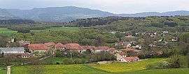
Peyriat
| Peyriat | |
|---|---|
 | |
 Peyriat | |
|
Location within Auvergne-Rhône-Alpes region  Peyriat | |
| Coordinates: 46°09′18″N 5°30′40″E / 46.155°N 5.5111°ECoordinates: 46°09′18″N 5°30′40″E / 46.155°N 5.5111°E | |
| Country | France |
| Region | Auvergne-Rhône-Alpes |
| Department | Ain |
| Arrondissement | Nantua |
| Canton | Izernore |
| Intercommunality | Monts Berthiand |
| Government | |
| • Mayor (2008–2014) | Pierre-Marie Benoît |
| Area1 | 5.93 km2 (2.29 sq mi) |
| Population (2008)2 | 166 |
| • Density | 28/km2 (73/sq mi) |
| Time zone | CET (UTC+1) |
| • Summer (DST) | CEST (UTC+2) |
| INSEE/Postal code | 01293 / 01430 |
| Elevation |
557–815 m (1,827–2,674 ft) (avg. 630 m or 2,070 ft) |
|
1 French Land Register data, which excludes lakes, ponds, glaciers > 1 km² (0.386 sq mi or 247 acres) and river estuaries. 2 Population without double counting: residents of multiple communes (e.g., students and military personnel) only counted once. | |
Peyriat is a commune in the Ain department in eastern France.
Population
| Historical population | ||
|---|---|---|
| Year | Pop. | ±% |
| 1962 | 97 | — |
| 1968 | 85 | −12.4% |
| 1975 | 87 | +2.4% |
| 1982 | 120 | +37.9% |
| 1990 | 154 | +28.3% |
| 1999 | 158 | +2.6% |
| 2008 | 166 | +5.1% |
See also
References
| Wikimedia Commons has media related to Peyriat. |
This article is issued from Wikipedia - version of the 3/15/2016. The text is available under the Creative Commons Attribution/Share Alike but additional terms may apply for the media files.