Jayat
| Jayat | |
|---|---|
|
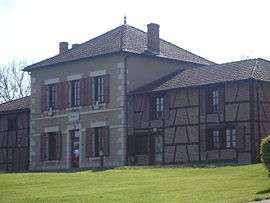
Town hall | |
 Jayat | |
|
Location within Auvergne-Rhône-Alpes region  Jayat | |
| Coordinates: 46°22′17″N 5°07′18″E / 46.3714°N 5.1217°ECoordinates: 46°22′17″N 5°07′18″E / 46.3714°N 5.1217°E | |
| Country | France |
| Region | Auvergne-Rhône-Alpes |
| Department | Ain |
| Arrondissement | Bourg-en-Bresse |
| Canton | Montrevel-en-Bresse |
| Intercommunality | Montrevel-en-Bresse |
| Government | |
| • Mayor (2008–2014) | Daniel Bereziat |
| Area1 | 16.3 km2 (6.3 sq mi) |
| Population (2008)2 | 994 |
| • Density | 61/km2 (160/sq mi) |
| Time zone | CET (UTC+1) |
| • Summer (DST) | CEST (UTC+2) |
| INSEE/Postal code | 01196 / 01340 |
| Elevation | 183–218 m (600–715 ft) |
|
1 French Land Register data, which excludes lakes, ponds, glaciers > 1 km² (0.386 sq mi or 247 acres) and river estuaries. 2 Population without double counting: residents of multiple communes (e.g., students and military personnel) only counted once. | |
Jayat is a commune in the Ain department in eastern France.
Population
| Historical population | ||
|---|---|---|
| Year | Pop. | ±% |
| 1793 | 1,053 | — |
| 1800 | 1,128 | +7.1% |
| 1806 | 1,125 | −0.3% |
| 1821 | 1,176 | +4.5% |
| 1831 | 1,218 | +3.6% |
| 1836 | 1,192 | −2.1% |
| 1841 | 1,231 | +3.3% |
| 1846 | 1,236 | +0.4% |
| 1851 | 1,269 | +2.7% |
| 1856 | 1,244 | −2.0% |
| 1861 | 1,224 | −1.6% |
| 1866 | 1,211 | −1.1% |
| 1872 | 1,180 | −2.6% |
| 1876 | 1,152 | −2.4% |
| 1881 | 1,130 | −1.9% |
| 1886 | 1,140 | +0.9% |
| 1891 | 1,104 | −3.2% |
| 1896 | 1,058 | −4.2% |
| 1901 | 1,038 | −1.9% |
| 1906 | 1,030 | −0.8% |
| 1911 | 1,004 | −2.5% |
| 1921 | 857 | −14.6% |
| 1926 | 876 | +2.2% |
| 1931 | 885 | +1.0% |
| 1936 | 863 | −2.5% |
| 1946 | 822 | −4.8% |
| 1954 | 778 | −5.4% |
| 1962 | 758 | −2.6% |
| 1968 | 713 | −5.9% |
| 1975 | 698 | −2.1% |
| 1982 | 681 | −2.4% |
| 1990 | 650 | −4.6% |
| 1999 | 773 | +18.9% |
| 2008 | 994 | +28.6% |
See also
References
| Wikimedia Commons has media related to Jayat. |
This article is issued from Wikipedia - version of the 2/11/2016. The text is available under the Creative Commons Attribution/Share Alike but additional terms may apply for the media files.