Indiana State Road 14
| ||||
|---|---|---|---|---|
 | ||||
| Route information | ||||
| Maintained by INDOT | ||||
| Length: | 122.98 mi[1] (197.92 km) | |||
| Major junctions | ||||
| West end: |
| |||
|
| ||||
| East end: |
| |||
| Location | ||||
| Counties: | Allen, Fulton, Jasper, Kosciusko, Newton, Pulaski, Whitley | |||
| Highway system | ||||
| ||||

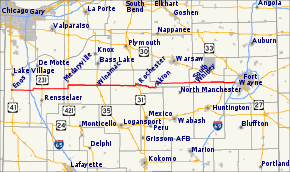
State Road 14 is an east–west road in northern Indiana. Its western terminus is at U.S. Route 41 in Enos, and its eastern terminus is at Interstate 69 in Fort Wayne.
In August 2005, construction on a new ramp connecting State Road 14 to Interstate 65 was completed. Winamac is the only control city listed, and is approximately 40 miles (64 km) east of the interchange. The ramp is noted for direct access to Fair Oaks Farms, immediately west of the interchange.
History
Until 1995, State Road 14 continued east of I-69, following Illinois Road to Washington Boulevard (westbound) and Jefferson Boulevard (eastbound), then following Washington Boulevard through downtown Fort Wayne. East of the city center, State Road 14 briefly joined State Road 930. It then split from SR-930 in New Haven, continuing east on Lincoln Highway and Dawkins Road to its former eastern terminus at the village of Edgerton, Indiana at the Ohio state line. This segment was decommissioned in 1995 with the opening of Interstate 469.
Major intersections
| County | Location | mi[1] | km | Destinations | Notes |
|---|---|---|---|---|---|
| Newton | Enos | 0.00 | 0.00 | Western Terminus of SR 14 | |
| 6.10 | 9.82 | ||||
| Jasper | Newton Township | 9.39 | 15.11 | ||
| Union Township | 16.57 | 26.67 | |||
| Barkley Township | 22.06 | 35.50 | Southern terminus of SR 49 | ||
| Pulaski | White Post Township | 30.07 | 48.39 | Southern end of US 421 concurrency | |
| 32.08 | 51.63 | Northern end of US 421 concurrency | |||
| Jefferson Township | 38.05 | 61.24 | |||
| Winamac | 46.98 | 75.61 | Southern end of US 35 concurrency | ||
| 47.10 | 75.80 | Northern end of US 35 concurrency | |||
| Fulton | Union Township | 56.56 | 91.02 | ||
| Rochester | 67.34 | 108.37 | Western end of SR 25 concurrency | ||
| 69.29 | 111.51 | Eastern end of SR 25 concurrency | |||
| Akron | 78.31 | 126.03 | |||
| Kosciusko | Silver Lake | 87.68 | 141.11 | ||
| Jackson Township | 95.46 | 153.63 | |||
| Whitley | South Whitley | 101.69 | 163.65 | Western end of SR 5 concurrency | |
| 102.33 | 164.68 | Eastern end of SR 5 concurrency | |||
| 110.26 | 177.45 | ||||
| Allen | Fort Wayne | 122.98 | 197.92 | Eastern terminus of SR 14 | |
1.000 mi = 1.609 km; 1.000 km = 0.621 mi
| |||||
References
- 1 2 "INDOT Roadway Referencing System" (PDF). staff.