Auburn, Indiana
| Auburn, Indiana | ||
|---|---|---|
| City | ||
|
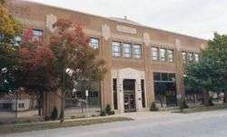
Main Street in downtown Auburn, Indiana | ||
| ||
| Nickname(s): Home of the Classics | ||
 Location in the state of Indiana | ||
| Coordinates: 41°21′56″N 85°3′23″W / 41.36556°N 85.05639°WCoordinates: 41°21′56″N 85°3′23″W / 41.36556°N 85.05639°W | ||
| Country | United States | |
| State | Indiana | |
| County | DeKalb | |
| Township | Grant, Union, Keyser, Jackson | |
| Government | ||
| • Mayor | Norman E. Yoder (R) | |
| Area[1] | ||
| • Total | 7.10 sq mi (18.39 km2) | |
| • Land | 7.10 sq mi (18.39 km2) | |
| • Water | 0 sq mi (0 km2) | |
| Elevation[2] | 866 ft (264 m) | |
| Population (2010)[3] | ||
| • Total | 12,731 | |
| • Estimate (2012)[4] | 12,787 | |
| • Density | 1,793.1/sq mi (692.3/km2) | |
| Time zone | EST (UTC-5) | |
| • Summer (DST) | EDT (UTC-4) | |
| ZIP code | 46706 | |
| Area code | 260 | |
| FIPS code[2][5] | 18-02674 | |
| GNIS ID[2][5] | 430334 | |
| Website |
www | |

| Historical population | |||
|---|---|---|---|
| Census | Pop. | %± | |
| 1850 | 260 | — | |
| 1860 | 639 | 145.8% | |
| 1870 | 677 | 5.9% | |
| 1880 | 1,542 | 127.8% | |
| 1890 | 2,415 | 56.6% | |
| 1900 | 3,396 | 40.6% | |
| 1910 | 3,919 | 15.4% | |
| 1920 | 4,650 | 18.7% | |
| 1930 | 5,088 | 9.4% | |
| 1940 | 5,415 | 6.4% | |
| 1950 | 5,879 | 8.6% | |
| 1960 | 6,350 | 8.0% | |
| 1970 | 7,388 | 16.3% | |
| 1980 | 8,122 | 9.9% | |
| 1990 | 9,379 | 15.5% | |
| 2000 | 12,074 | 28.7% | |
| 2010 | 13,086 | 8.4% | |
| Est. 2015 | 12,979 | [6] | −0.8% |
Auburn is a city in DeKalb County, Indiana, United States. The population was 13,086 at the 2010 census. Founded in 1836 by Wesley Park (1811–1868), the city is the county seat of DeKalb County.[8] Auburn is also known as Home of the Classics.
Geography
Auburn is located at 41°21′56″N 85°03′23″W / 41.365505°N 85.056355°W[9] 20 miles north of Fort Wayne in Northern Indiana. Interstate 69 passes just west of the city.
According to the 2010 census, the city has a total area of 7.10 square miles (18.4 km2), all land.[10]
Most of Auburn is located in Union civil township. Portions of Jackson, Keyser and Grant civil townships are also within the city limits.
Climate
Auburn has typical continental weather with very warm summers and very cold winters. Average January temperatures are a high of 31.4 °F (−0.3 °C) and a low of 17.2 °F (−8.2 °C). Average July temperatures are a high of 83.9 °F (28.8 °C) and a low of 62.0 °F (16.7 °C). There are an average of 13.1 days with highs of 90 °F (32 °C) or higher and an average of 136.8 days with lows of 32 °F (0 °C) or lower. The record high temperature was 106 °F (41 °C) on June 26, 1988. The record low temperature was −24 °F (−31 °C) on January 21, 1984.[11]
Average annual precipitation in Auburn is 35.47 inches (901 mm). The wettest month is normally June, with an average of 4.17 inches (106 mm). The wettest year was 1985 with 43.50 inches (1,105 mm) and the driest year was 1964 with 19.93 inches (506 mm). The most precipitation in one month was 9.65 inches (245 mm) in June 1981. The most precipitation in 24 hours was 3.85 inches (98 mm) on August 20, 1904. There is an average of 32.4 inches (820 mm) of snow each year. The snowiest season was 1981-82 with 67.5 inches (1,710 mm), including 30.0 inches (760 mm) in January 1982. The most snowfall in 24 hours was 14.0 inches (360 mm) on January 26, 1978.[12]
History
Auburn's site on Cedar Creek was chosen by Wesley Park and John Badlam Howe at the intersection of two major trails, Goshen-Defiance Road and Coldwater Road, and next to the land of John Houlton.[13] The name for the community likely came from "The Deserted Village" by Oliver Goldsmith, that begins "Sweet Auburn! Loveliest village of the plain."[14] The plat of the Village of Auburn is dated April 21, 1836, but it was held by Howe and not recorded until March 12, 1879. John Drury purchased the first lot (Lot 73) for $25.00 on September 5, 1837. The first store was built at Park's corners by Thomas Freeman, applying for a license on March 5, 1838, and bringing supplies by horseback from Fort Wayne. Daniel Altenburg, Levi Walsworth, the Sherlock family, Samuel Sprott, David Weave, David Shoemaker, Henry Curtis, Lyman Childsey, James Cosper, and David Cosper were early residents.
A post office was established in 1839.[15] In 1841, malaria ran through the town, and in 1843 a terrible storm wreaked havoc on cabins and crops. The Church of God was built by the Presbyterians in 1846. The Village of Auburn was incorporated in 1849, divided into wards, and governed under a town board and constable. By the end of the American Civil War, the town included over 700 inhabitants. The storm of September 29, 1872, destroyed Odd Fellow's Hall and damaged the Methodist Episcopal church. A few months later (April 6, 1873), the new brick block of Seventh Street (Snyder's Building) collapsed, also destroying the Ensley Building.[16] Auburn water and lights was constructed in 1898. The change in status to the City of Auburn on March 26, 1900 followed a referendum. Notable citizen Charles Eckhart erected a public library and a YMCA building. The Auburn Automobile Company founded in 1900 produced its first automobile in 1903.[17] William Wrigley, Jr. and Errett Lobban Cord controlled interests in the company that eventually acquired Duesenberg, Lexington, and Lycoming. The company failed in August 1937. The Auburn Rubber Company was started in 1913 as the Double Fabric Tire Company, making tires for Auburn Automobile Company. In the 1920s as Auburn Rubber, it became a large manufacturer of rubber toys, leaving Auburn in 1959.
Notorious bank robber John Dillinger and some accomplices raided Auburn's police station on October 14, 1933, stealing a submachine gun, two steel vests, three rifles, six pistols and over 1000 rounds of ammunition.[18] The acts that led to the U.S. Supreme Court's decision in Stump v. Sparkman, 435 U.S. 349 (1978), the leading American case on judicial immunity, took place in Auburn in 1971. On June 28, 1988, four workers were asphyxiated at a local metal-plating plant in the worst confined-space industrial accident in U.S. history; a fifth victim died two days later.[19]
The Auburn Community Mausoleum, Auburn Cord Duesenberg Automobile Facility, Downtown Auburn Historic District, and Eckhart Public Library and Park are listed on the National Register of Historic Places.[20][21]
Demographics

2010 census
As of the 2010 census,[3] there were 12,731 people, 5,226 households, and 3,322 families residing in the city. The population density was 1,793.1 inhabitants per square mile (692.3/km2). There were 5,692 housing units at an average density of 801.7 per square mile (309.5/km2). The racial makeup of the city was 96.9% White, 0.4% African American, 0.2% Native American, 0.7% Asian, 0.7% from other races, and 1.0% from two or more races. Hispanic or Latino of any race were 2.6% of the population.
There were 5,226 households of which 32.5% had children under the age of 18 living with them, 46.0% were married couples living together, 12.3% had a female householder with no husband present, 5.2% had a male householder with no wife present, and 36.4% were non-families. 31.2% of all households were made up of individuals and 13.9% had someone living alone who was 65 years of age or older. The average household size was 2.38 and the average family size was 2.96.
The median age in the city was 37.9 years. 25.3% of residents were under the age of 18; 8.1% were between the ages of 18 and 24; 25.9% were from 25 to 44; 25.1% were from 45 to 64; and 15.6% were 65 years of age or older. The gender makeup of the city was 48.1% male and 51.9% female.
2000 census
As of the 2000 census,[22] there were 12,074 people, 4,927 households, and 3,202 families residing in the city. The population density was 1,816.2 people per square mile (701.0/km²). There were 5,258 housing units at an average density of 790.9 per square mile (305.3/km²). The racial makeup of the city was 97.71% White, 0.35% African American, 0.10% Native American, 0.41% Asian, 0.02% Pacific Islander, 0.61% from other races, and 0.80% from two or more races. Hispanic or Latino of any race were 1.75% of the population.
There were 4,927 households out of which 33.4% had children under the age of 18 living with them, 51.2% were married couples living together, 10.1% had a female householder with no husband present, and 35.0% were non-families. 30.1% of all households were made up of individuals and 12.2% had someone living alone who was 65 years of age or older. The average household size was 2.41 and the average family size was 2.99.
In the city the population was spread out with 26.4% under the age of 18, 9.2% from 18 to 24, 30.7% from 25 to 44, 19.9% from 45 to 64, and 13.7% who were 65 years of age or older. The median age was 34 years. For every 100 females there were 92.5 males. For every 100 females age 18 and over, there were 89.0 males.
The median income for a household in the city was $42,762, and the median income for a family was $52,687. Males had a median income of $38,007 versus $24,414 for females. The per capita income for the city was $20,945. About 2.9% of families and 5.2% of the population were below the poverty line, including 3.4% of those under age 18 and 7.5% of those age 65 or over.
Government


Auburn is governed by an elected mayor and seven-member common council and a three-member board of public works and safety consisting of the mayor and two others appointed by the mayor. Five members of the common council are elected from individual districts and two are elected at-large. A list of persons who have served as mayor appears in the table below.
| Mayors of Auburn | Term(s) |
|---|---|
| Donald A. Garwood | 1900–1902 |
| Thomas H. Sprott | 1902–1904 |
| James W.Y. McClellan | 1904–1906 1914–1918 |
| George O. Dennison | 1906–1910 |
| Hugh Culbertson | 1910–1914 |
| Eli C. Walker | 1918–1922 |
| Warren Lige | 1922–1935 |
| Lodi E. Potter | 1935–1948 |
| Hal E. Hoham | 1949–1952 |
| H. Gerald Oren | 1952–1964 |
| Clarren L. Boger | 1964–1968 |
| Donald M. Allison | 1968–1972 |
| John L. Foley | 1972–1976 |
| Jesse A. ("Jack") Sanders | 1976–1984 |
| Burtis L. Dickman | 1984–1992 |
| Norman N. Rohm | 1992–2000 |
| Norman E. Yoder | 2000— |
Media
- Radio stations
- 1570 AM WGLL—religious
- 102.3 FM WGBJ—"Mega 102.3" Licensed to Auburn, studios in Fort Wayne, Indiana
Activities
The Dekalb County Free Fall Fair is held in down town Auburn. It starts at the end of September and has over 850,000 guests a year.
- Television stations
- Newspaper
- The Star, (formerly known as The Evening Star)
Education
Most of Auburn lies in the DeKalb County Central United School District. Public schools serving Auburn are:
- James R. Watson Elementary School
- McKenney-Harrison Elementary School
- DeKalb Middle School (Waterloo)
- DeKalb High School (Waterloo)
There is also a K-12 private school:
- Lakewood Park Christian School
Events and sites of interest
Auburn is the location of the Auburn Cord Duesenberg Festival, held each Labor Day weekend, and of the Auburn Cord Duesenberg Automobile Museum and the National Automotive and Truck Museum of the United States. Both are National Historic Landmarks. The Auburn Cord Duesenberg Festival, with the annual Labor Day auction, is said to host the world's largest automotive auction. These automotive-related events are the legacy of the Auburn Automobile Company, which closed in the late 1930s. The company had its headquarters and a factory in Auburn. Other museums located near Auburn include the Hoosier Air Museum, the Kruse Automotive and Carriage Museum and the World War II Victory Museum. Auburn also hosts the annual DeKalb County Free Fall Fair, a six-day event usually held in the last week of September.
Auburn was also home to early automobile company DeSoto in 1913. This company has no connection with the DeSoto that was manufactured by Chrysler.
Notable people
- Gordon Buehrig (1904–1990), automobile designer, lived in Auburn for two years while designing the 1935–1936 Auburn Speedster and is buried in Roselawn Cemetery.
- Errett Lobban Cord (1894–1974), industrialist, lived in Auburn while running the Auburn Automobile Company.
- Will Cuppy (1884–1949), humorist and journalist, was born in Auburn, graduated from Auburn High School and is buried in Evergreen Cemetery.
- Charles Eckhart (1841–1915), industrialist and philanthropist, founded the Eckhart Carriage Company, predecessor of the Auburn Automobile Company, and was Prohibition Party candidate for Governor of Indiana in 1900. He lived in Auburn from 1874 until his death and is buried in Woodlawn Cemetery.
- James I. Farley (1871–1948), member of US House of Representatives, 1933–1939, lived in Auburn while an executive of the Auburn Automobile Company and is buried in Woodlawn Cemetery.
- Walter Hartman Hodge (1896–1975) was a lawyer and judge.
- Don Lash (1912–1994), track-and-field champion who won the 1938 James E. Sullivan Award as the top amateur athlete in the United States, graduated from Auburn High School in 1933.
- Charles A.O. McClellan (1835–1898), member of US House of Representatives, 1889–1892, lived in Auburn and practiced law there.
- Rollie Zeider (1883-1967), early 20th Century infielder in Major League Baseball, was born in Cass County and raised in Auburn.
City logo
The official city logo, pictured at right, is based on the logo of the former Auburn Automobile Company. The company went out of business in the 1930s. The municipality began using the logo in the 1980s. The city's official nickname is '"Home of the Classics,"' a reference to the "classic" automobiles once manufactured there.
References
- ↑ "Places (2010)" (Zipped TXT). 2010 Census Gazetteer Files. United States Census Bureau. Retrieved 2012-12-11. External link in
|work=(help) - 1 2 3 "Feature ID 430334". Geographic Names Information System. United States Geological Survey. Retrieved June 30, 2014.
- 1 2 "American FactFinder". United States Census Bureau. Retrieved 2012-12-11.
- ↑ "Population Estimates". United States Census Bureau. Archived from the original on June 17, 2013. Retrieved 2013-06-25.
- 1 2 "FIPS55 Data: Indiana". FIPS55 Data. United States Geological Survey. February 23, 2006. Archived from the original on June 18, 2006. Retrieved June 30, 2014. External link in
|work=(help) - ↑ "Annual Estimates of the Resident Population for Incorporated Places: April 1, 2010 to July 1, 2015". Retrieved July 2, 2016.
- ↑ "Census of Population and Housing". Census.gov. Archived from the original on May 11, 2015. Retrieved June 4, 2015.
- ↑ "Find a County". National Association of Counties. Archived from the original on May 31, 2011. Retrieved 2011-06-07.
- ↑ "US Gazetteer files: 2010, 2000, and 1990". United States Census Bureau. 2011-02-12. Retrieved 2011-04-23.
- ↑ "2010 Census U.S. Gazetteer Files for Places – Indiana". United States Census. Retrieved 2012-04-21.
- ↑ "Temperature Summary - 120334 AUBURN, IN". Mcc.sws.uiuc.edu. Archived from the original on 2012-02-25. Retrieved 2012-02-14.
- ↑ "Precipitation Summary - 120334 AUBURN, IN". Mcc.sws.uiuc.edu. Archived from the original on 2012-02-25. Retrieved 2012-02-14.
- ↑ "detailed city history". Ingenweb.org. Retrieved 2012-02-14.
- ↑ City Parks and Recreation
- ↑ "DeKalb County". Jim Forte Postal History. Retrieved 3 September 2014.
- ↑ "USA Cities". Usacitiesonline.com. 2011-02-28. Retrieved 2012-02-14.
- ↑ "Automotive History of Auburn". Automotivehistoryonline.com. 2012-01-27. Retrieved 2012-02-14.
- ↑ John Toland, The Dillinger Days, Da Capo Press edition, 1995 p. 132 ISBN 978-0-306-80626-1; G. Russell Girardin, William J. Helmer and Rick Mattix, Dillinger: The Untold Story, , Indiana University Press, 2005, p. 35. ISBN 0-253-32556-0
- ↑ Joseph A. Kinney and William G. Mosley, "Death on the Job," The Multinational Monitor, April 1990, v. 11, no. 4, citing a report by the National Institute for Occupational Safety and Health.
- ↑ National Park Service (2010-07-09). "National Register Information System". National Register of Historic Places. National Park Service.
- ↑ "National Register of Historic Places Listings". Weekly List of Actions Taken on Properties: 3/24/14 through 3/28/14. National Park Service. 2014-04-04.
- ↑ "American FactFinder". United States Census Bureau. Archived from the original on September 11, 2013. Retrieved 2008-01-31.
External links
- City of Auburn, Indiana website
- DeKalb County Central United School District
- Auburn Cord Duesenberg Museum
- Auburn Cord Duesenberg Festival
- NATMUS
- WWII Victory Museum
- Hoosier Air Museum
- Kruse Automotive and Carriage Museum
- DeKalb Visitors Bureau
- Eckhart Public Library
- Downtown Auburn Business Association
Image gallery
-

U.S. Post Office, completed in 1934.
-

DeKalb County Court House.
-

Eckhart Public Library, 1996 addition.
-

Old Vandalia Railroad Bridge over Cedar Creek in Auburn.
-

Childhood home of author Will Cuppy.
-

Author Will Cuppy's gravestone, Evergreen Cemetery.
-

A storefront church in Auburn.
-

Auburn Automobile Company historical marker.
| Counties |  | |
|---|---|---|
| Municipalities with population over 10,000 in 2010 | ||
| Municipalities with population 1,000-10,000 in 2010 | ||
| Municipalities with population under 1,000 in 2010 | ||
| CDPs | ||
Municipalities and communities of DeKalb County, Indiana, United States | ||
|---|---|---|
| Cities | ||
| Towns | ||
| Townships | ||
| Unincorporated communities | ||
| Footnotes | ‡This populated place also has portions in an adjacent county or counties | |