Lake Forest Park, Washington
| City of Lake Forest Park | ||
|---|---|---|
| City | ||
| ||
| Nickname(s): LFP | ||
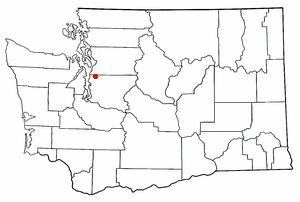
 Location of Lake Forest Park in King County and Washington | ||
| Coordinates: 47°45′24″N 122°17′23″W / 47.75667°N 122.28972°WCoordinates: 47°45′24″N 122°17′23″W / 47.75667°N 122.28972°W | ||
| Country | United States | |
| State | Washington | |
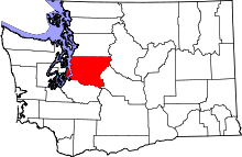
| County | King | |
| Incorporated | 1961 | |
| Government | ||
| • Mayor | Jeff Johnson | |
| Area[1] | ||
| • Total | 3.65 sq mi (9.45 km2) | |
| • Land | 3.53 sq mi (9.14 km2) | |
| • Water | 0.12 sq mi (0.31 km2) | |
| Elevation | 69 ft (21 m) | |
| Population (2010)[2] | ||
| • Total | 12,598 | |
| • Estimate (2015)[3] | 13,243 | |
| • Density | 3,568.8/sq mi (1,377.9/km2) | |
| Time zone | PST (UTC-8) | |
| • Summer (DST) | PDT (UTC-7) | |
| ZIP code | 98155 | |
| Area code(s) | 206 | |
| FIPS code | 53-37270 | |
| GNIS feature ID | 1512366[4] | |
| Website | http://www.cityoflfp.com/ | |

Lake Forest Park is a city in King County, Washington, United States, just north of Seattle. A bedroom community by design, most of the city consists of single-family housing on medium to large-sized lots. Less than 4% of the city land is zoned commercial; most of that is in one location, and there are no industrial areas.
Lake Forest Park is situated along the shore of Lake Washington, and includes parks and nature preserves, convenient access to the Burke-Gilman Trail, a summertime farmer's market, and a large new and used bookstore / food court holding frequent musical events. The population was 12,598 at the 2010 census.
History
Lake Forest Park was founded in 1912 by Ole Hanson as one of the Seattle area's first planned communities. Envisioned as a picturesque retreat for professionals, the developers planned roads and lots in strict consideration for natural landmarks.[5] The original prospectus for lot sales declared:
...the strict fiat has gone forth that all the natural beauty must be preserved; that no tree must unwittingly be cut down; that the natural wild flowers must remain; that the streams, the springs, the lake front, the nodding willows, the stately cedar, the majestic fir, the quivering cypress and the homelike maple and all the flora and fauna with which Nature has blessed this lakeshore, must not be defiled by the hand of man.[6]
Until 1914 and completion of the Red Brick Road (now Bothell Way, part of State Route 522) to nearby Kenmore and Bothell, it also marked the literal end of improved roads heading north from Seattle, with the best access to points further north and east being by boat across Lake Washington or the Seattle, Lake Shore and Eastern Railway.
Lake Forest Park officially incorporated on June 20, 1961, in large part to help maintain its specific identity.[7] The town remained small - under 5,000 in population - until the 1990s, when a series of annexations expanded city borders significantly and more than doubled the official population.
The 3/4 acre Lyon Creek Park was created in the late 1990s on land purchased by the city in 1998. For the prior fifty years, the lot had belonged to Marcia and Robert Morris, who had built a modernist home and a horse stable on the property. Both buildings were torn down as part of the park conversion, which also included replanting the park with 5,000 native shrubs and plants. The replanting portion of the project involved the labor of hundreds of citizen volunteers.[8]
Lake Forest Park Town Center, the city's commercial core, was built in 1964 and hugs Bothell Way, not far from the lakeshore. In late 2005, city government began holding public meetings to discuss the future of the town center. The decision was made to renovate Lake Forest Park Town Center and it now spans 18 acres and offers many shopping and dining options along with entertainment. Lake Forest Park Town Center is also home to a branch of the King County Library System, Third Place Books, and Third Place Commons community center.[9][10]
Geography
Lake Forest Park is situated at the north end of Lake Washington. The city's southern boundary begins at the city limit of Seattle. To the north, Lake Forest Park ends at the Snohomish county line, where the adjacent towns of Mountlake Terrace and Brier border it. To the east, the city is bounded by Lake Washington and at 55th Avenue NE where the city of Kenmore begins; the Burke-Gilman Trail runs in parallel to the lake shore, following the shoreline into Kenmore to the north, and Seattle to the south. The city's western boundary is at the City of Shoreline's city limit, mostly following 25th Avenue NE.
According to the United States Census Bureau, the city has a total area of 3.65 square miles (9.45 km2), of which, 3.53 square miles (9.14 km2) is land and 0.12 square miles (0.31 km2) is water.[1] The two largest streams are Lyon Creek and McAleer Creek, both of which provide habitat for salmon.[11] The shoreline includes two private beach clubs but no public boat access to Lake Washington; however, Lyon Creek Waterfront Preserve offers 100 feet of Lake Washington shoreline and a viewing dock that extends out into the lake.[12]

Parks
- Horizon View Park is located at the highest point in Lake Forest Park and offers fields, a children’s playground with swings and a play train, a basketball half-court, tennis court, play field, picnic tables, and paved pathways through a natural, wooded area. Horizon View covers 8.4 acres and is located at 19800 47th Ave NE (198th St at 47th Ave NE).[13]
- Pfingst Animal Acres Park is located at NE 178th St and Brookside Blvd and features picnic tables, a 0.25 mile walking loop, a salmon viewing platform, and a beautiful dogwood flower-shaped drinking fountain for people and dogs. The park is also home to a bust of Admiral Miguel Grau Seminario that was presented to the City of Lake Forest Park by the Consulate General of Peru and the Peruvian Navy in 2011.[14]
- Eagle Scout Park is a small park located at NE 178th St at NE 180th St and features a picnic area as well as exercise bars perfect for walkers and runners.[15]
- Blue Heron Park is a 0.5 acre park located at NE 170th St at Hamlin Road, just off Bothell Way. This park features a pedestrian bridge that connects Brookside Boulevard NE with the Town Center and is popular with salmon and herons alike.[16]
- Grace Cole Nature Park is a 15.2 acre wetland named after distinguished Stare Representative Grace Cole and is located at 30th Ave NE at NE 166th St. The Lake Forest Park Stewardship Foundation hosts regular “ivy out” work parties in the summer to restore and preserve the wildlife habitat.[17]
- Lyon Creek Waterfront Preserve is located across the street from the Lake Forest Park Town Center at 17337 Beach Drive NE, next to the Lake Forest Park Civic Club. A short trail and boardwalk are perfect for viewing where Lyon Creek meets Lake Washington. This park includes 100 feet of Lake Washington shoreline.[18]
- Whispering Willow Park is found at 17038 44th Ave NE. The park features a short boardwalk, seating, and a natural children’s play area. It connects 44th Ave NE with the Lake Forest Park Town Center.[19]

Community Programs and Services
The City of Lake Forest Park uses strategic partnerships to offer residents community programs and services. A partnership with the City of Shoreline’s Recreation Department offers residents discounted access to a wide variety of programs including classes, workshops, and enrichment programs for all ages.[20] The City of Lake Forest Park also partners with the Shoreline/Lake Forest Park Arts Council, the Shoreline/Lake Forest Park Senior Center, and Hang Time(an extensive after school activity program offered by Kellogg Middle School and the YMCA). In addition, the City of Lake Forest Park provides funds to the Center for Human Services which offers mental health counseling, drug and alcohol treatment, outreach and education services to residents who qualify based on income. The heart of the Town Center, Third Place Commons, is managed by the organization Friends of the Third Place Commons, a 501(c)3 nonprofit. The Third Place Commons offers a large space with a stage, restaurants, seating, a children’s play area, free Wi-Fi, and a meeting room. Third Place Commons also runs the outdoor Lake Forest Park Farmers Market that runs on Sundays from May to October with over 45 vendors.[21]
Neighborhoods
Lake Forest Park Town Center forms the city's commercial core. This one complex includes the public library, police department, city hall, and approximately 40 shops, small businesses, and medical/professional offices.[22] Third Place Commons is a large public space that occupies much of the central building's upper level.[23] In the summer, this same complex hosts a large outdoor farmer's market.[24] Until late 2007, the city was also served by a finance unit post office in the same complex, the functions of which have since been moved to nearby Shoreline. The Town Center was also home to Shoreline Community College's Lake Forest Park satellite campus but it is now closed.
Residential neighborhoods include:
- Horizon View, in the northeast corner of the city, is characterized by its proximity to Horizon View Park, the highest point in Lake Forest Park. The park sits atop a small plateau, approached by several steep hills. Half of the "train park", as some local youth refer to it, is the park, which was improved between 2001 and 2003, also in early 2013 with a trail extension, field upgrades and a new playset. The other half is a reservoir. They hold recreational sports in the park.
- Sheridan Beach/Heights, in the southeast corner of the city, is characterized by its proximity to the Sheridan Beach Club, to which its residents have access for a fee.
Demographics
| Historical population | |||
|---|---|---|---|
| Census | Pop. | %± | |
| 1970 | 2,530 | — | |
| 1980 | 2,485 | −1.8% | |
| 1990 | 4,031 | 62.2% | |
| 2000 | 13,142 | 226.0% | |
| 2010 | 12,598 | −4.1% | |
| Est. 2015 | 13,243 | [25] | 5.1% |
| U.S. Decennial Census[26] 2015 Estimate[3] | |||
Based on per capita income, one of the more reliable measures of affluence, Lake Forest Park ranks 26th of 614 areas in the state of Washington to be ranked.
2010 census
As of the census[2] of 2010, there were 12,598 people, 5,024 households, and 3,502 families residing in the city. The population density was 3,568.8 inhabitants per square mile (1,377.9/km2). There were 5,268 housing units at an average density of 1,492.4 per square mile (576.2/km2). The racial makeup of the city was 83.0% White, 1.8% African American, 0.6% Native American, 8.8% Asian, 0.2% Pacific Islander, 1.0% from other races, and 4.7% from two or more races. Hispanic or Latino of any race were 3.6% of the population.
There were 5,024 households of which 30.2% had children under the age of 18 living with them, 58.6% were married couples living together, 7.8% had a female householder with no husband present, 3.3% had a male householder with no wife present, and 30.3% were non-families. 23.0% of all households were made up of individuals and 7.9% had someone living alone who was 65 years of age or older. The average household size was 2.49 and the average family size was 2.92.
The median age in the city was 45 years. 20.8% of residents were under the age of 18; 6.4% were between the ages of 18 and 24; 22.8% were from 25 to 44; 34.9% were from 45 to 64; and 15.1% were 65 years of age or older. The gender makeup of the city was 49.7% male and 50.3% female.
2000 census
As of the census of 2000, there were 13,142 people, 5,029 households, and 3,600 families residing in the city. The population density was 3,716.2 people per square mile (1,433.4/km²). There were 5,168 housing units at an average density of 1,461.4 per square mile (563.7/km²). The racial makeup of the city was 85.32% White, 1.64% African American, 0.43% Native American, 7.94% Asian, 0.11% Pacific Islander, 0.92% from other races, and 3.64% from two or more races. Hispanic or Latino of any race were 2.24% of the population.
There were 5,029 households out of which 31.8% had children under the age of 18 living with them, 61.1% were married couples living together, 7.9% had a female householder with no husband present, and 28.4% were non-families. 21.2% of all households were made up of individuals and 6.4% had someone living alone who was 65 years of age or older. The average household size was 2.55 and the average family size was 2.97.
In the city the population was spread out with 22.4% under the age of 18, 6.5% from 18 to 24, 26.6% from 25 to 44, 31.5% from 45 to 64, and 13.0% who were 65 years of age or older. The median age was 42 years. For every 100 females there were 97.8 males. For every 100 females age 18 and over, there were 93.1 males.
The median income for a household in the city was $74,149, and the median income for a family was $84,316. Males had a median income of $53,164 versus $39,531 for females. The per capita income for the city was $33,419. About 1.3% of families and 3.8% of the population were below the poverty line, including 2.3% of those under age 18 and 2.2% of those age 65 or over.
Education
Of the city's population over the age of 25, 21.1 percent have a graduate or professional degree, 51.1 percent (vs. a national average of 24 percent) hold a bachelor's degree or higher, and 93.2 percent (vs. 80 percent nationally) have a high school diploma or equivalent according to the census of 2000.
There are two public schools (Brookside Elementary and Lake Forest Park Elementary) which are served by the Shoreline School District.
References
- 1 2 "US Gazetteer files 2010". United States Census Bureau. Retrieved 2012-12-19.
- 1 2 "American FactFinder". United States Census Bureau. Retrieved 2012-12-19.
- 1 2 "Population Estimates". United States Census Bureau. Retrieved June 19, 2016.
- ↑ "Lake Forest Park". Geographic Names Information System. United States Geological Survey.
- ↑ Stein, A., "Lake Forest Park -- Thumbnail History", HistoryLink.org, 5 December 1998. Online as of 19 April 2007.]
- ↑ Alan J. Stein transcribing Ole Hanson, "Lake Forest Park brochure", Seattle, Washington, 1912, held by Shoreline Historical Museum, Shoreline, Washington, 1998.
- ↑ "Once a refuge from 'disagreeable things'". Seattle Post-Intelligencer. 31 Oct 2002. Retrieved 17 June 2016.
- ↑ Informational signs in Lyon Creek Park, City of Lake Forest Park, March 2007.
- ↑ "City Center". Lake Forest Park Washington. Retrieved 20 June 2016.
- ↑ Madison Marquette, http://www.madisonmarquette.com/portfolio/property/property:69, Retrieved 2010-12-1.
- ↑ City of Lake Forest Park (May 2008). "The Legacy 100-Year Vision Final Report". Retrieved 17 June 2016.
- ↑ "Lyon Creek Waterfront Preserve". Lake Forest Park Washington. Retrieved 17 June 2016.
- ↑ "Horizon View Park". Lake Forest Park Washington. Retrieved 16 June 2016.
- ↑ "Pfingst Animal Acres Park". Lake Forest Park Washington. Retrieved 16 June 2016.
- ↑ "Eagle Scout Park". Lake Forest Park Washington. Retrieved 16 June 2016.
- ↑ "Blue Heron Park". Lake Forest Park Washington. Retrieved 16 June 2016.
- ↑ "Grace Cole Nature Park". Lake Forest Park Washington. Retrieved 16 June 2016.
- ↑ "Lyon Creek Waterfront Preserve". Lake Forest Park Washington. Retrieved 16 June 2016.
- ↑ "Whispering Willow Park". Lake Forest Park Washington. Retrieved 16 June 2016.
- ↑ "Recreation Opportunities Outside of Lake Forest Park". Lake Forest Park Washington. Retrieved 22 June 2016.
- ↑ "About". Third Place Commons. Retrieved 22 June 2016.
- ↑ Lake Forest Park Town Center Store Directory, Madison Marquette Mallfinder Network LLC, online as of 24 August 2008.
- ↑ Stadler, Anne. "How a Failing Suburban Mall Became a Beloved Indoor Town Square". Project for Public Spaces. Retrieved 17 June 2016.
- ↑ "Farmer's Market". Third Place Commons. Retrieved 17 June 2016.
- ↑ "Annual Estimates of the Resident Population for Incorporated Places: April 1, 2010 to July 1, 2015". Retrieved July 2, 2016.
- ↑ United States Census Bureau. "Census of Population and Housing". Retrieved July 31, 2013.
Further reading
- Alan J. Stein, Lake Forest Park -- Thumbnail History, HistoryLink.org, Seattle, Washington, 1998
- Alan J. Stein transcribing Ole Hanson, Lake Forest Park brochure, Seattle, Washington, 1912, held by Shoreline Historical Museum, Shoreline, Washington, 1998.
- Community, City of Lake Forest Park, Lake Forest Park, Washington, 2016
- History of Lake Forest Park, City of Lake Forest Park, Lake Forest Park, Washington, 2016
External links
- City of Lake Forest Park
- Lake Forest Park Farmer's Market
- Burke Gilman Regional Trail
- Grace Cole Nature Park
Municipalities and communities of King County, Washington, United States | ||
|---|---|---|
| Cities |
|  |
| Towns | ||
| CDPs |
| |
| Unincorporated communities | ||
| Indian reservation | ||
| Ghost towns | ||
| Footnotes | ‡This populated place also has portions in an adjacent county or counties | |
 |
Mountlake Terrace | Brier | Brier | |
| Shoreline | |
Kenmore | ||
| ||||
| | ||||
| Shoreline / Seattle | Seattle | Lake Washington |