Cumberland, Washington
| Cumberland | |
|---|---|
| Unincorporated community | |
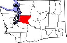
 Cumberland Location within the state of Washington | |
| Coordinates: 47°16′59″N 121°55′32″W / 47.28306°N 121.92556°WCoordinates: 47°16′59″N 121°55′32″W / 47.28306°N 121.92556°W | |
| Country | United States |
| State | Washington |
| County | King |
| Time zone | Pacific (PST) (UTC-8) |
| • Summer (DST) | PDT (UTC-7) |
| GNIS feature ID | 1518407[1] |
Cumberland is an unincorporated community in King County, Washington. Originally a mining camp, Cumberland was named by F.X. Schreiner in 1893 after the Cumberland coal region of the Appalachian Mountains.[2] Cumberland gained a post office on October 13, 1894. Today, the Enumclaw post office serves this area. Although many other mining camps in the area have disappeared, Cumberland can still be found in the Cascade foothills between Nolte State Park and Kanaskat-Palmer State Park. It is accessible via Southeast King County backroads. Cumberland has an all volunteer fire department and is a King County registered voting precinct.
In 1989 the county-wide transit and sewage waste municipality known as "Metro" (short for Metropolitan King County), planned a 25-year sewage sludge waste spraying on the 400 acres (1.6 km2) of woods northwest of the town. Following grassroots community protest and objections from the Muckleshoot Native American tribe (who are downriver on the nearby Green River), the county agreed to create an Environmental impact statement (EIS). The EIS showed a number of toxins present in the sludge, and the project was officially cancelled in 1992.
References
- ↑ "Cumberland". Geographic Names Information System. United States Geological Survey.
- ↑ Majors, Harry M. (1975). Exploring Washington. Van Winkle Publishing Co. p. 91. ISBN 978-0-918664-00-6.
Municipalities and communities of King County, Washington, United States | ||
|---|---|---|
| Cities |
|  |
| Towns | ||
| CDPs |
| |
| Unincorporated communities | ||
| Indian reservation | ||
| Ghost towns | ||
| Footnotes | ‡This populated place also has portions in an adjacent county or counties | |