Fairwood, King County, Washington
| Fairwood, Washington | |
|---|---|
| CDP | |
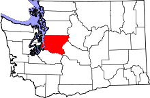
 Location of Cascade-Fairwood, Washington | |
| Coordinates: 47°26′49″N 122°08′37″W / 47.44694°N 122.14361°WCoordinates: 47°26′49″N 122°08′37″W / 47.44694°N 122.14361°W | |
| Country | United States |
| State | Washington |
| County | King |
| Area[1] | |
| • Total | 4.86 sq mi (12.59 km2) |
| • Land | 4.86 sq mi (12.59 km2) |
| • Water | 0.0 sq mi (0.0 km2) |
| Population (2010) | |
| • Total | 19,102 |
| • Density | 3,927.2/sq mi (1,517.2/km2) |
| Time zone | Pacific (PST) (UTC-8) |
| • Summer (DST) | PDT (UTC-7) |
| FIPS code | 53-10372[2] |
| GNIS feature ID | 2407983[3] |
Fairwood is an unincorporated community and census-designated place (CDP) in King County, Washington, United States. The population of the CDP was 19,102 at the 2010 census. The population of the King County Incorportion area of Fairwood is 25,000 as of 2007.[4]
Fairwood has a variety of single-family housing developments, and some multi-family dwellings interspersed with rural and undeveloped areas. The area includes two distinct business areas serving the local population. The area surrounding the Fairwood library has the most developed businesses (retail, personal and professional services), generally located in major shopping centers anchored by chain grocery stores. The primary interests of residents are centered on home life, recreation, and quality of life issues such as crime and education.[5] The CDP was formerly known as Cascade-Fairwood until the Cascade area was annexed to the city of Renton in 2008.
History
The Fairwood area was settled in the late 1880s with coal mining, farming and ranching as the major activities. In those times, transportation was limited, especially in the winter. There were several lakeside resorts used by Seattle area residents for fishing and day trips.
Indians and early settlers found the Cedar River which runs through the valley below Fairwood to be the shortest route from Puget Sound to Eastern Washington. The valley, north of the library, was heavily wooded with narrow and rough trails making travel difficult. The lack of a direct route and the condition of the trails, muddy in winter and rocky in summer, hindered settlement along the valley.
As early as 1870, Martin Cavanaugh discovered coal in the area now bordered by 196th SE and the Maple Valley Highway just below Cedar Mountain in eastern Fairwood. In 1882 the Black Diamond Coal Company of California surveyed the Cedar River Valley for coal and found enough good prospects to warrant a search and the financing of a railroad. They ended up selling the rail rights to Henry Villard of the Northern Pacific who developed the railroad under the name of Columbia & Puget Sound Railway. In 1904 this railway was sold to the Pacific Coast Coal Company which later became part of the Chicago, Milwaukee & St. Paul electrified line.
With development of the railway came settlers, many of whom worked in the mines and lived in small cedar shacks on hillsides and along the river. In 1884 James M. Colman began to mine the Cedar Mountain area, and his family helped to start and operate the small town of Cedar Mountain. It consisted of a store, hotel, boarding house, sawmill, post office, a couple of saloons and many small homes. The children who lived at the top of the mountain went to two schools: Cedar Mountain and Crosson. Crosson was located at the present intersection of 196th and Shadow Lake Road and has since been remodeled into a residence.
One of the first known buildings in the Fairwood area is the Elliott Dairy Farm. It is a complex of eight buildings associated with the dairy farm of Robert James Elliott. The complex includes a large Craftsman-style dwelling, three barns, a feed house, milk house, equipment shed, and a carriage house with attached garage. It is the last remaining intact dairy farm in the area, as well as being the longest operating farm in the area. The dairy farm operated from 1906 to 1968, when the Elliott's grandson sold off the herd. Beef cattle were on the property until the early 1970s after which all farming operations ended. Since 1983 the house has been vacant, but it has been designated a King County Historical Landmark. In the vicinity of the Elliott farm there was a train stop known as Elliott Station (not named after Robert Elliott). This railroad stop was along the railway owned and operated by the Pacific Coast Coal Company.
The first school in the area was built near the Elliott farm and opened on November 8, 1885. All eight grades were taught in the schoolhouse and attendance ranged from two to two dozen. The school became part of the Renton School District in 1942 and closed its doors in 1962. The building was purchased by William Veenhuizen in 1947 and moved back to their farm which is located a short distance from the Elliott farm. William Veenhuizen is a long-time resident of the Fairwood area and was born in the farm to which he moved the schoolhouse. The school has since been turned into apartments.

The Aqua Barn Ranch, a large white, two story farmhouse with green shutters, is also one of the oldest structures in the Fairwood. In 1894 Samuel and Mary Denny bought 40 acres of what would eventually become the Aqua Barn Ranch. Samuel was a cousin of Arthur Denny, one of Seattle's founders. His wife, Mary, was the youngest daughter of Carson Boren, another early Seattle pioneer. They built a small farmhouse on the property and in 1889 sold it to Lars and Sine Hansen. Albert Hansen, the son of Lars and Sine, and his wife, Janette, moved into the house in 1916 and remodeled it as it appears today. They continued to operate the dairy until 1945 until their daughter, Mrs. Helen Flynn, and her husband took over the property in the 1950s. They turned the 60 acres of land and buildings into a rural recreation center which is still in operation today. The Madsen farm, close by the Hansen property, housed the first post office in the area near the Elliott train stop. the Aqua Barn and the Elliot Farm buildings remain standing along the Maple Valley Highway, as reminders of the early days.
Benson Highway, one of the major roads in the Fairwood area, is named after John H. Benson. In 1906 John and Elmer, his brother, bought several tracts of land in an area platted as Spring Glen Acre Tracts. They moved into an old homestead on Elmer's property until John was able to build a four-bedroom home on his piece of land. The only access to the property was on an old trail that slowed them down so much that they began to look for ways to build a road. They built a temporary road which was not passable in winter and this was the situation other settlers of the Spring Glen area faced until 1913 when the first portion of the Benson Road was built. That section was two miles long and connected the farm to Renton. Other sections of road were added over several decades until the John F. Benson Road reached from the Renton city limits to the city limits of Kent. East of Benson there was some farming, especially along the Cedar River along Jones Road (named after Ed Jones; his original ranch is now known as the Cook livestock farm), horse ranching, and a coal mine where the Fairwood Greens is located.
On the east side of fairwood, Art Foss's parents settled along Shadow Lake in 1927. They opened a small resort with cabins and a restaurant on the lake. Spring Lake, once known as Otter Lake, was often visited by Seattle fishermen who traveled by coal train up the valley and then hiked up the hill and rented rowboats from the Slusser family. Swan Lake, currently known as Lake Youngs, was also used by local residents as a place to swim, picnic and fish. Today Lake Youngs is in the Seattle watershed and is off limits to the public. The Seattle Water District has two pipelines, developed in the early 1900s, which run from the Cedar River at Landsburg through to Lake Youngs.
The Fairwood and Cascade area had many coal mines. The Lake Youngs coal mine was located where Petrovitsky Park is today. Fire King mine was located near what is known today as the Fairwood Greens. When the Fairwood Greens was developed in the early 1970s, many coal mining shafts were found and subsequently filled. A few miles west of the library on 116th SE near the Cascade Shopping Center, there was the Starkovitch Coal mine started in 1938 by the father of John Starkovitch. Martina, John's wife, indicates that she and her husband operated their mine until 1950 when it had to be shut down due to water filling up the mine shafts. Frank Plant operated a mine near Talbot Road and another mine named the Springbrook mine which was just west of the Cascade Vista area. The Wilson mine was located just west of the Benson Highway near the site of the Summerhill apartments.
The area as it is recognized today was developed in the early 1950s and 1960s. Cascade Vista began to be developed with homes in 1957 and the Cascade shopping center in 1959. Modern commercial development at the intersection of Benson and Petrovitsky started in earnest in 1959. The Fairwood Greens Golf course was completed in 1967 and major housing projects at Fairwood Greens, Fairwood West and Fairwood Crest began in 1968. Since that time the area surrounding the Fairwood library has developed rapidly with many new housing projects along 140th SE and also along Petrovitsky. Spring Glen Elementary was built in 1953 and most of the other schools in the area were constructed from 1962 (Cascade Elementary) through 1971 (Kentridge High School in 1968; Lindbergh High School which didn't open until 1973 due to a lack of students). In spite of the rapid development and influx of cars and people, you can still find reminders of how things may have been: horse farms, small sheep ranches, many winding rural roads with smaller old homes, lakes and ponds, and large tracts of undeveloped second growth forest.[5]
Economy
Employment
Residents are employed at a slightly higher rate than the rest of the County and the median income is $85,000 (versus $69,000 for King County). More than half of the workers in the Fairwood area work in south King County with less than a 30-minute commute. A significant number of Fairwood workers are in professional, management and sales jobs (70%).
Business
Commercial uses are clustered at the main crossroads of Petrovitsky Road and 140th Way SE. The commercial area is supported by an Albertsons and Safeway on either side of Petrovitsky, and a large series of local retail and office establishments. The area adjacent to the library has the most developed businesses (retail, personal and professional services), which are generally located in major shopping centers anchored by the chain grocery stores. Closures, vacancies and some new business have created a changing landscape in the commercial districts. There are two large shopping centers in Fairwood, located on 140th: Fairwood Square located north of Petrovitsky and Fairwood Center south of Petrovitsky. Fairwood Plaza, a strip mall is located further east of Fairwood Square to the north of Petrovitsky. A smaller strip mall, the Cascade Center contains a bowling alley and a few chain stores, it had featured a hooters but it recently closed down.
Fairwood Library
− In 1964, the Cascade-Spring Glen Community Club requested that the King County Library System (KCLS) start a library in their club-owned building at 11635 SE 170th Place. A lease was signed in November and the Vista Library was born. It was furnshed with an establishment grant from the Washington State Library and the collection was supplied by KCLS. KCLS purchased the Vista Library building in 1967 and the Cascade-Spring Glen Community Club donated $10,000 for remodeling costs. The remodeling began in February 1969 and was completed in April. The Vista Library reopened the remodeled 1,440-square-foot facility on May 19, 1969, complete with new landscaping donated by the Carriage Lane Garden Club. As a result of a lid lift approval in March 1980, planning for construction of a new Fairwood Library and three other KCLS buildings began. The residents of Fairwood had been so excited about the prospect of a new library that they organized a committee and helped distribute 10,000 copies of a flyer urging residents to vote “yes” on the library proposition. After the lid lift was passed, Mithun Architects was chosen to design the new Fairwood Library on 140th Avenue SE, across from the entrance to the Fairwood Golf Course. The Fairwood/Vista Library Friends generated an enormous amount of community support for the new building, including a special book fair with local authors and other special events. The new 15,000-square-foot library, with a capacity of 90,000 items, opened its door on January 21, 1986. Later that year, on October 4, 1986, an oil painting of Mount Rainier by Byron Birdsall entitled “Sentinel” was installed in honor of Harold O. Sternberg, a KCLS’ construction coordinator who was instrumental in the development of the Fairwood Library. In 1987, the Fairwood Library won an American Institute of Architects (AIA)/American Library Association (ALA) Award of Excellence for its design.[6] The library was renovated in 2013/2014, increasing the floor area by 1/3. [7]
Geography
Cascade-Fairwood is located at 47°26′49″N 122°08′37″W / 47.44694°N 122.14361°W (47.447062, -122.143586).[8] According to the United States Census Bureau, the CDP has a total area of 3.6 square miles (9.3 km²).
The Fairwood area forms a plateau which extends from the bluffs of the Cedar River Valley on the north and east down to State Route 167 and the Kent Valley on the West. Fairwood includes opens spaces, towering trees, many neighborhoods and several commercial districts. It surrounds the Seattle watershed of Lake Youngs on the south, and borders Renton to the east, and Maple Valley to the southeast. The Fairwood area features five sizable lakes, timberland, and farmland. The incorporation area of Fairwood is 6.2-square-miles.
Neighborhoods[9][10]
|
|
|
Climate
Fairwood's climate features cool/mild wet winter, and a dry-summer. The warmest month of the year in Cascade-Fairwood within the past 3–6 years is July with an average maximum high of 106 °F and an average minimum low of 48 °F. The coldest months of the year are December, with an average min low of 15 °F and an average max high of 72 °F.
Autumn, winter, and spring are frequently characterized by rain, in the Seattle area, while the summers are fairly dry and warm by comparison. Fairwood's location closer to downslope winds from the Cascade Mountains means it can get fairly hot in the summers. An exception to the damp weather occurs in El Nino years when the Seattle area stays fairly dry
Fairwood typically receives some snowfall on an annual basis, but heavy snow is rare.
Geographic location
 |
Renton | East Renton Highlands | Issaquah | |
| Renton/Kent | |
Hobart | ||
| ||||
| | ||||
| Kent | Covington | Maple Valley |
Parks and recreation
There are many large lakes and community parks in the Fairwood area
- Fairwood Golf & Country Club - A large 18 hole golf course located in the Fairwood Greens neighborhood. It features 6,316 yards of golf from the longest tees for a par of 71. The country club includes a heated 8-lane junior Olympic sized pool, and fitness gym.[11][12]
- Spring Lake / Lake Desire Park - Located in eastern Fairwood between Lake Desire and Spring Lake. It features an 11-mile backcountry trail for hiking, horseback riding and mountain biking.[13]
- Soos Creek Trail and Park - In western Fairwood, home to a large riparian habitat great for birdwatching of ducks, song birds, and raptors. The 12 mile long Soos Creek trail was extended up to Fairwood in the late 2000s.
- McGarvey Park - Features a 1.2 mile hiking trail up Cedar Mountain (Echo Mountain) through evergreen forest, passing over Peterson Creek. It features spectacular views of Mount Rainier on the summit of Cedar Mountain.[14]
- Petrovitsky Park - Located just north of Petrovitsky Rd, an 88-acre park with 4 baseball fields and soccer fields, a playground, and picnic areas.[15][16]
- Cedar River Trail - North of the Fairwood plateau the trail hugs the winding Cedar River from Renton to Maple Valley.[6]
Education
Fairwood is served by three school districts, Renton, Kent, and Tahoma. Schools in the Fairwood area are:
High schools
Middle schools
Elementary schools
- Renton Park ES
- Carriage Crest ES
- Fairwood ES
- Glenridge ES
- Lake Youngs ES
- Ridgewood ES
- Springbrook ES
Major roads
There are three major arterials that run through Fairwood. Petrovitsky Road Runs through the east/west through Fairwood's commercial core and many of its neighborhoods. It stretches from downtown Renton, near the Boeing Renton Factory, and Boeing Commercial Aviation; where many Fairwood residents work, to Maple Valley, winding through the rural timberland, ranches, and farms of eastern Fairwood. 140th Avenue runs north/south adjacent to the Fairwood shopping centers and Soos Creek. It stretches from Maple Valley highway on the north and leads 9 miles to Green River Community College by way of Kent's east hill. State Route 169 (Maple Valley highway) on the northern end of Fairwood provides short access to Interstate 405.
Public safety
Fairwood Fire Protection and Emergency Medical Services are served by Fire Districts 40 and 37. The Fire District 40 station is located on Petrovitsky Rd in the center of Fairwood. The King County Sheriff provides policing services to the area, with a Sheriff's substation located in Fairwood Center. Valley Medical Center at Fairwood provides medical services and specializes in family medicine, behavioral health, and internal medicine.[17]
Demographics
| Historical population | |||
|---|---|---|---|
| Census | Pop. | %± | |
| 1980 | 16,939 | — | |
| 1990 | 30,107 | 77.7% | |
| 2000 | 34,580 | 14.9% | |
| 2010 | 19,102 | −44.8% | |
As of the census[2] of 2000, there were 34,580 people, 13,065 households, and 9,197 families residing in the CDP. The population density was 3,898.6 people per square mile (1,505.2/km²). There were 13,456 housing units at an average density of 1,517.0/sq mi (585.7/km²). The racial makeup of the CDP was 72.95% White, 6.09% African American, 0.60% Native American, 13.50% Asian, 0.46% Pacific Islander, 1.88% from other races, and 4.51% from two or more races. Hispanic or Latino of any race were 4.11% of the population.
There were 13,065 households out of which 35.4% had children under the age of 18 living with them, 56.6% were married couples living together, 9.9% had a female householder with no husband present, and 29.6% were non-families. 22.4% of all households were made up of individuals and 4.7% had someone living alone who was 65 years of age or older. The average household size was 2.65 and the average family size was 3.14.
In the CDP the population was spread out with 26.2% under the age of 18, 8.4% from 18 to 24, 33.1% from 25 to 44, 24.7% from 45 to 64, and 7.6% who were 65 years of age or older. The median age was 35 years. For every 100 females there were 98.6 males. For every 100 females age 18 and over, there were 96.3 males.
The median income for a household in the CDP was $57,996, and the median income for a family was $66,811. Males had a median income of $47,094 versus $33,886 for females. The per capita income for the CDP was $25,752. About 4.6% of families and 5.9% of the population were below the poverty line, including 9.0% of those under age 18 and 4.1% of those age 65 or over.
As of the census[2] of 2010, there were 19,000 people, and 7,516 households in the CDP. The population density was 3,898.6 people per square mile (1,505.2/km²). There were 13,456 housing units at an average density of 1,517.0/sq mi (585.7/km²). The racial makeup of the CDP was 65.3% White, 7.4% African American, 0.50% Native American, 17.6% Asian, 0.60% Pacific Islander, 4.51% from two or more races, 6.5% Hispanic or Latino of any race
The median income for a household in the CDP was $88,859, and the median income for a family was $66,811. Males had a median income of $47,094 versus $33,886 for females. The per capita income for the CDP was $38,624. About 3.0% of the population were below the poverty line.[1]
The population of the Fairwood incorporation area is 25,000 with a land area of 6.27 square miles. The population is expected to grow up to 28,783 residents in 2015.[4]
Politics
On the national level, Cascade-Fairwood leans towards candidates of the Democratic Party. Democrat John Kerry received about 56 percent of the vote in 2004 to Republican George W. Bush's 43 percent. Despite this, there are a number of pockets where the Republican Party often wins marginal majorities.
The Cascade area (approximately a population of 17,000), which included much of unincorporated Benson Hill north of SE 200 St. and west of 128th Ave. SE, voted to annex to the City of Renton in 2007 and this became effective March 1, 2008. The remaining unincorporated area of King County, which is primarily the Fairwood community, has the option of annexing to the City of Renton or incorporating as a city.
In February 2005, the Fairwood Task Force filed a Notice of Intent to Incorporation with King County, Washington, to establish a new City of Fairwood. This attempt to incorporate the City of Fairwood was very narrowly defeated in the election held on September 19, 2006. In that election, 48.22% of the votes were for incorporation; a swing of only 136 votes in the election would have changed the result.
The process to form a City of Fairwood was restarted by the Fairwood Municipal Initiative when it filed a Notice of Proposed Incorporation with King County, Washington on April 16, 2007.[18] As of October 2008, the incorporation effort is now under the jurisdiction of the King County Boundary Review Board (BRB)[19] and a consulting firm hired by the BRB is conducting an economic feasibility study for the proposed City of Fairwood.
On November 3, 2009 Proposition 1 to incorporate a City of Fairwood failed again as it did in 2006.
Efforts are also ongoing to annex the Fairwood area into the City of Renton.[20] Additionally, the Red Mill area of the Fairwood PAA is presently undertaking a separate petition method annexation.[21]
On November 2, 2010, 57.6% of voters voted against a proposition to annex Fairwood to Renton.[22]
References
- 1 2 "Fairwood CDP (King), Washington". United States Census Bureau. Retrieved 28 February 2013.
- 1 2 3 "American FactFinder". United States Census Bureau. Retrieved 2008-01-31.
- ↑ "Fairwood Census Designated Place". Geographic Names Information System. United States Geological Survey.
- 1 2 "City of Fairwood Incorporation Study" (PDF). King County. Retrieved 28 February 2013.
- 1 2 "Fairwood Community History". King County Library System.
- 1 2 "Engage. Fairwood Library 2011 Community Study" (PDF). http://www.kcls.org. KCLS. Retrieved 15 February 2013. External link in
|work=(help) - ↑ http://www.saarch.com/projects/king-county-library-system-fairwood-library.php
- ↑ "US Gazetteer files: 2010, 2000, and 1990". United States Census Bureau. 2011-02-12. Retrieved 2011-04-23.
- ↑ "Communities A-G". http://fairwoodcommunitynews.com. 2012 Fairwood Community News, Inc. Retrieved 15 February 2013. External link in
|work=(help) - ↑ "Communities H-Z". http://fairwoodcommunitynews.com. 2012 Fairwood Community News, Inc. Retrieved 15 February 2013. External link in
|work=(help) - ↑ "Services > Swim & Fitnes". Fairwood Golf & Country Club. Retrieved 15 February 2013.
- ↑ "Fairwood Golf & Country Club, Fairwood Golf Course". GolfLink. Demand Media, Inc. Retrieved 15 February 2013.
- ↑ "Spring Lake / Lake Desire Park" (PDF). http://your.kingcounty.gov. King County, Washington. Retrieved 15 February 2013. External link in
|work=(help) - ↑ Hite, Will. "McGarvey Park, Renton - Cedar Mountain". WillhiteWeb.com. WillhiteWeb. Retrieved 15 February 2013.
- ↑ Milan, Frana. "Shiny new fields coming to Petrovitsky Park". King County Parks Plog. WordPress. Retrieved 15 February 2013.
- ↑ "PETROVITSKY PARK". http://thespotsport.com. The Spot Sport. Retrieved 15 February 2013. External link in
|work=(help) - ↑ "Valley Medical Center Fairwood Clinic". Valley Medical Center. Retrieved 28 February 2013.
- ↑ Fairwood Municipal Initiative
- ↑ King County Boundary Review Board
- ↑ Choose Renton
- ↑ Red Mill Annexation Map
- ↑ Results - King County Elections
Municipalities and communities of King County, Washington, United States | ||
|---|---|---|
| Cities |
|  |
| Towns | ||
| CDPs |
| |
| Unincorporated communities | ||
| Indian reservation | ||
| Ghost towns | ||
| Footnotes | ‡This populated place also has portions in an adjacent county or counties | |