Snoqualmie Pass, Washington
| Snoqualmie Pass, Washington | |
|---|---|
| CDP | |
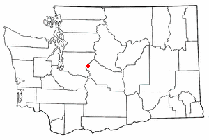
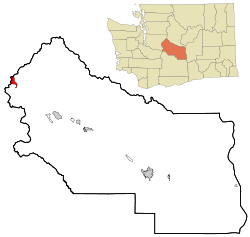 Location of Snoqualmie Pass, Washington | |
| Coordinates: 47°23′32″N 121°24′0″W / 47.39222°N 121.40000°W | |
| Country | United States |
| State | Washington |
| County | Kittitas |
| Area | |
| • Total | 2.9 sq mi (7.4 km2) |
| • Land | 2.9 sq mi (7.4 km2) |
| • Water | 0.0 sq mi (0.0 km2) |
| Elevation | 2,726 ft (831 m) |
| Population (2010) | |
| • Total | 311 |
| • Density | 70.1/sq mi (27.1/km2) |
| Time zone | Pacific (PST) (UTC-8) |
| • Summer (DST) | PDT (UTC-7) |
| ZIP code | 98068 |
| Area code(s) | 425 |
| FIPS code | 53-65275[1] |
| GNIS feature ID | 1852958[2] |
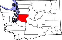
Snoqualmie Pass is a census-designated place (CDP) in King and Kittitas County, Washington, United States. The population was 311 at the 2010 census.
The CDP is named for the mountain pass that carries Interstate 90 across the Cascade Range, which itself is named for the Snoqualmie tribe, a Native American tribe indigenous to the Snoqualmie Valley located west of the pass.
Based on per capita income, Snoqualmie Pass ranks 8th of 522 areas in the state of Washington to be ranked. It is also the highest rank achieved in Kittitas County.
With Interstate 90 and the King County/Kittitas County lines splitting Snoqualmie Pass at roughly perpendicular directions, the community lies in two counties, two different zip codes from two different main post offices, two different congressional districts and two different legislative districts. None of these districts have the same border in the community.
Recreation
The area consists of mountain chalets that are mainly seasonally occupied by residents of the Seattle metropolitan area, with approximately 150 year-round residents. Winter sports are the main draw, but outdoor recreation is available year round.
The Pacific Crest Trail crosses through Snoqualmie Pass and a variety of other trails are also available for hiking and climbing in the summer, cross-country skiing and snowshoeing during the winter months.
Snoqualmie Pass is also the site of the Summit at Snoqualmie, a group of alpine ski areas managed by Boyne USA Resorts. The Summit consists of four ski areas: Alpental, Summit West (formerly named Snoqualmie Summit), Summit Central (formerly Ski Acres), and Summit East (formerly Hyak). The Summit at Snoqualmie is the closest ski area to Seattle, so it is often crowded on weekends.
Snowmobiling just east of the pass is also popular during the winter months. Also in the summer and fall, paragliders and hang gliders may be seen flying above the valley, along the ridge and landing at Lake Keechelus.
Geography
According to the United States Census Bureau, the CDP has a total area of 2.9 square miles (7.4 km²), all of it land. Situated at a main crossing point of the Cascade Mountains, Snoqualmie Pass is located in the center of the Mountains to Sound Greenway, which spans parts of King and Kittitas County.
Surrounding Cities and Communities
 |
North Bend | | ||
| |
||||
| ||||
| | ||||
| Hyak |
Climate
Due to its high elevation, Snoqualmie Pass experiences significantly lower temperatures than Seattle, and receives much more precipitation, much of it being snow. Snoqualmie Pass has a humid continental climate (Koppen:Dfb) with cold, very wet and snowy winters, and mild to warm, relatively dry summers.
| Climate data for SNOQUALMIE PASS, WASHINGTON | |||||||||||||
|---|---|---|---|---|---|---|---|---|---|---|---|---|---|
| Month | Jan | Feb | Mar | Apr | May | Jun | Jul | Aug | Sep | Oct | Nov | Dec | Year |
| Average high °F (°C) | 31.9 (−0.1) |
37 (3) |
42.4 (5.8) |
49.3 (9.6) |
57.2 (14) |
62.9 (17.2) |
70.4 (21.3) |
69.6 (20.9) |
64.6 (18.1) |
53.9 (12.2) |
39.3 (4.1) |
33.4 (0.8) |
51.16 (10.64) |
| Average low °F (°C) | 21.1 (−6.1) |
23.6 (−4.7) |
26.1 (−3.3) |
30.4 (−0.9) |
34.5 (1.4) |
40.4 (4.7) |
46 (8) |
46.2 (7.9) |
41.7 (5.4) |
35.6 (2) |
28.2 (−2.1) |
24.1 (−4.4) |
32.68 (0.38) |
| Average precipitation inches (mm) | 12.47 (316.7) |
8.95 (227.3) |
7.35 (186.7) |
5.69 (144.5) |
4.32 (109.7) |
3.98 (101.1) |
1.86 (47.2) |
2.2 (56) |
4.16 (105.7) |
6.45 (163.8) |
12.84 (326.1) |
13.88 (352.6) |
84.15 (2,137.4) |
| Average snowfall inches (cm) | 69.9 (177.5) |
52.5 (133.4) |
55.5 (141) |
39.5 (100.3) |
18.5 (47) |
1.6 (4.1) |
0.3 (0.8) |
0 (0) |
1.4 (3.6) |
17.2 (43.7) |
75.4 (191.5) |
74.9 (190.2) |
406.7 (1,033) |
| Source #1: [3] | |||||||||||||
| Source #2: [4] | |||||||||||||
Demographics
As of the census[1] of 2000, there were 201 people, 88 households, and 60 families residing in the CDP. The population density was 70.1 people per square mile (27.0/km²). There were 330 housing units at an average density of 115.0/sq mi (44.4/km²). The racial makeup of the CDP was 93.03% White, 1.00% Asian, 1.00% Pacific Islander, and 4.98% from two or more races. Hispanic or Latino of any race were 0.50% of the population.
There were 88 households out of which 23.9% had children under the age of 18 living with them, 61.4% were married couples living together, 2.3% had a female householder with no husband present, and 31.8% were non-families. 21.6% of all households were made up of individuals and 2.3% had someone living alone who was 65 years of age or older. The average household size was 2.28 and the average family size was 2.68.
In the CDP the population was spread out with 18.9% under the age of 18, 6.0% from 18 to 24, 37.3% from 25 to 44, 29.9% from 45 to 64, and 8.0% who were 65 years of age or older. The median age was 40 years. For every 100 females there were 109.4 males. For every 100 females age 18 and over, there were 111.7 males.
The median income for a household in the CDP was $81,883, and the median income for a family was $89,532. Males had a median income of $50,417 versus $26,875 for females. The per capita income for the CDP was $54,316. None of the families and 1.9% of the population were living below the poverty line.
References
- 1 2 "American FactFinder". United States Census Bureau. Retrieved 2008-01-31.
- ↑ "Snoqualmie Pass". Geographic Names Information System. United States Geological Survey.
- ↑ "SNOQUALMIE PASS, WASHINGTON". Retrieved July 14, 2014.
- ↑ "Snoqualmie Pass, Washington". Retrieved July 14, 2014.
External links
- Cascade Times, local newspaper that serves the area
- History Link
- U.S. Geological Survey Geographic Names Information System: Snoqualmie Pass
Municipalities and communities of Kittitas County, Washington, United States | ||
|---|---|---|
| Cities | 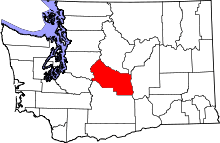 | |
| Town | ||
| CDPs | ||
| Unincorporated communities | ||
| Indian reservation | ||
| Ghost towns | ||
| Footnotes | ‡This populated place also has portions in an adjacent county or counties | |
Municipalities and communities of King County, Washington, United States | ||
|---|---|---|
| Cities |
|  |
| Towns | ||
| CDPs |
| |
| Unincorporated communities | ||
| Indian reservation | ||
| Ghost towns | ||
| Footnotes | ‡This populated place also has portions in an adjacent county or counties | |
Coordinates: 47°23′32″N 121°24′0″W / 47.39222°N 121.40000°W